Kalamalka Lake
| Kalamalka Lake | |
|---|---|
 | |
| Location | southern central British Columbia |
| Coordinates | 50°10′25″N 119°19′48″W / 50.17361°N 119.33000°WCoordinates: 50°10′25″N 119°19′48″W / 50.17361°N 119.33000°W |
| Lake type | Glacial Lake |
| Primary outflows | Vernon Creek |
| Basin countries | Canada |
| Max. length | 16 km (52,000 ft) |
| Max. width | 3 km (9,800 ft) |
| Surface area | 25.7 km2 (9.9 sq mi) |
| Average depth | 58.5 m (192 ft) |
| Max. depth | 142 m (466 ft) |
| Water volume | 1.5 km3 (0.36 cu mi) |
| Residence time | 55.2 years |
| Shore length1 | 42.4 km (26.3 mi) (approx.) |
| Surface elevation | 392 m (1,286 ft) |
| Settlements | Coldstream, Lake Country |
| 1 Shore length is not a well-defined measure. | |
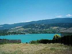
Kalamalka Lake (aka "Kal Lake") is a large lake in the Interior Plateau of southern central British Columbia, Canada, east of Okanagan Lake and approximately 4 kilometres (2.5 mi) south of Vernon.[1] The lake is named for the Okanagan (Okanogan U.S. spelling) Indian chief who occupied its northern shores.
At different times of the year the colour of the lake can range from cyan to indigo, in different spots at the same time. The colour of the water is derived from light scattering, caused by the precipitation of calcite (CaCO3).
Hydrology
Kalamalka Lake is a glacial lake. The main inflow to Kalamalka Lake is from Wood Lake that is located to the south and connected by a canal at Oyama. The lake is drained by Vernon Creek[2] which exits at the north end of the lake and passes through the city of Vernon and flows into the Okanagan Lake.
Tourism
Kalamalka Lake is also a home to many great beaches. Kal beach and Cosens Bay Beach, which lies right in the heart of Kalamalka Lake Provincial Park, are two of the popular beaches developed on the shores of the lake. Some of the other beaches on this lake are Jade Bay Beach, Juniper Bay Beach, Kekuli Bay Beach, Kirkland Park Beach, and on the south end, Kaloya Regional Park Beach.
Two provincial parks are situated along Kalamalka Lake, Kalamalka Lake Provincial Park and Protected Area[3] (4209 ha) and Kekuli Bay Provincial Park[4] (57 ha).
There are many resorts on the lake, including Owl's Nest Resort (features the only marina on the lake), Klub Kal, and more. Kalamalka lake receives very little fishing pressure as the Lake is used mostly for recreational boating and water skiing.
References
- Anonymous (1974a). Kalamalka-Wood Lake Basin Water Resource Management Study. Water Investigations Branch, British Columbia Water Resources Service, Victoria, B.C., 209 pp.
- Anonymous (1974b). Limnology of the Major Lakes in the Okanagan Basin. Canada - British Columbia Okanagan Basin Agreement, Final Report, Technical Supplement V. British Columbia Water Resources Service, Victoria, British Columbia, 261 pp.
- Anonymous (1974c). The Main Report of the Consultative Board. Canada - British Columbia Okanagan Basin Agreement. British Columbia Water Resources Service, Victoria, British Columbia.
- Stockner, J.G. and Northcote, T.G. (1974). Recent limnological studies of Okanagan Basin lakes and their contribution to comprehensive water resource planning. Journal of the Fisheries Research Board of Canada, 31, 955-976.
External links
- Natural Resources Canada. Atlas of Canada. Map of Kalamalka Lake
Municipalities and communities of Okanagan, British Columbia, Canada | ||
|---|---|---|
| Cities | 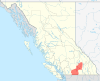 | |
| Towns | ||
| Districts | ||
| Villages | ||
| Designated places |
| |
| Unincorporated communities | ||
| Indian reservations | ||
| Ghost towns | ||
| Footnotes | ‡This populated place also has portions in an adjacent region | |