Kamchatka Krai
| Kamchatka Krai Камчатский край (Russian) | |||
|---|---|---|---|
| — Krai — | |||
| |||
 | |||
| |||
|
| |||
| Political status | |||
| Country | Russia | ||
| Federal district | Far Eastern[2] | ||
| Economic region | Far Eastern[3] | ||
| Established | July 1, 2007[4] | ||
| Krai Day | July 1[5] | ||
| Administrative center | Petropavlovsk-Kamchatsky[6] | ||
| Government (as of June 2015) | |||
| • Governor[7] | Vladimir Ilyukhin[8] | ||
| • Legislature | Legislative Assembly[7] | ||
| Statistics | |||
| Area (as of the 2002 Census)[9] | |||
| • Total | 472,300 km2 (182,400 sq mi) | ||
| Area rank | 10th | ||
| Population (2010 Census)[10] | |||
| • Total | 322,079 | ||
| • Rank | 76th | ||
| • Density[11] | 0.68/km2 (1.8/sq mi) | ||
| • Urban | 77.35% | ||
| • Rural | 22.65% | ||
| Population (January 2015 est.) | |||
| • Total | 317,206[12] | ||
| Time zone(s) | PETT (UTC+12:00)[13] | ||
| ISO 3166-2 | RU-KAM | ||
| License plates | 41, 82 | ||
| Official languages | Russian[14] | ||
| Official website | |||
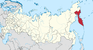
Kamchatka Krai (Russian: Камча́тский край, tr. Kamchatsky kray; IPA: [kɐmˈtɕatskʲɪj kraj]) is a federal subject of Russia (a krai). It was formed on July 1, 2007, as a result of the merger of Kamchatka Oblast and Koryak Autonomous Okrug, based on the voting in a referendum on the issue on October 23, 2005.
The krai's administrative center is the city of Petropavlovsk-Kamchatsky. The okrug retains the status of a special administrative division of the krai, under the name of Koryak Okrug. As of the 2010 Census, the population of the krai was 322,079.[10]
Geography
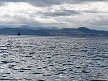
Kamchatka Krai occupies the territory of the Kamchatka Peninsula, the adjacent part of the mainland, the island Karaginsky and Commander Islands. Washed in the east Bering Sea of Pacific Ocean (length of the coast more than 2,000 kilometers (1,200 mi)), from the west – the Okhotsk Sea (the length of the coast about 2,000 kilometers (1,200 mi)).
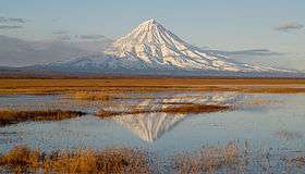
Mountain ranges: Sredinny Range (the length of about 900 kilometres (560 mi)), East, Vetveysky, Penzhinsky, Pahachinsky, Olyutorskij et al. Heights: Khuvkhoitun (2,613 meters (8,573 ft)), the Ice (2,562 meters (8,406 ft)), Acute (2,552 meters (8,373 ft)), Shishel (2,531 meters (8,304 ft)), Tylele volcano (2,234 meters (7,329 ft)).
Kamchatka belongs to the zone of volcanic activity, there are about 300 large and medium-sized volcanoes, 29 of them are active. The largest volcano in Eurasia – Kluchevskaya (altitude 4,750 meters (15,580 ft)). With the volcanic activity associated with the formation of many minerals, as well as a manifestation of hydro geo thermal activity: education fumaroles, geysers, hot springs, etc.
The climate is mostly subarctic, more continental in the hinterland and more maritime and prone to monsoons on the coast.
Nature
Most of the peninsula is covered with forests of stone birch, in the upper parts of the mountain slopes are common alder and cedar elfin. In the central part, especially in the valley of the Kamchatka River, widespread forests of larch and spruce Kuril Ajan. In floodplains, forests grow with fragrant poplar, alder, hairy, Chosenia, willow Sakhalin. In the second tier, and the undergrowth common hawthorn zelenomyakotny, Asian cherry, rowan Kamchatka, shrubs – Kamchatka elderberries, rosehips tupoushkovy, rowan buzinolistnaya, honeysuckle Kamchatka, meadowsweet, willow shrubs, and many other species. Kamchatka, especially coastal areas, characterized by tall – species such as shelamaynik Kamchatka, angelica bearish, sweet parsnip reach a height of 3–4 meters.
More than 14.5% of the territory of the Kamchatka Territory refers to the specially protected. There are six protected areas of federal significance (three state reserves, one federal reserve "South Kamchatka", two spa areas – "Resort Paratunka", "Malkinskie mineral waters"); four natural parks of regional significance ("Nalychevo", "Bystrinsky", "South Kamchatka", "Kluchevskoy"); 22 reserve of regional importance; 116 monuments of nature; four protected areas (landscape natural park "Blue Lake", Southwest and Tundra Sobolewski reserves).
Kronotsky Nature Reserve is a nature area reserved for the study of natural sciences in the remote Russian Far East, on the coast of the Kamchatka Peninsula.[15] It was created in 1934 and its current boundary contains an area of 10,990 square kilometers (4,240 sq mi).[15] It also has Russia's only geyser basin, plus several mountain ranges with numerous volcanoes, both active and extinct. Due to its often harsh climate and its mix of volcanoes and geysers, it is frequently described as the "Land of Fire and Ice".[16]
It is mainly accessible only to scientists, plus approximately 3,000 tourists annually who pay a fee equivalent to US$700 to travel by helicopter for a single day's visit.[16] Kronotsky Nature Reserve has been proclaimed a World Heritage Site by UNESCO.[17]
Administrative divisions
Economy
The main industries in Kamchatka include fishing and forestry. Coal and other raw materials are extracted. Due to its geographical location near major shipping routes, it is a center for shipbuilding, ship repair, and related services.[18] There are also oil and mineral resources which are yet to be fully developed.[19]
Demographics
Population: 322,079 (2010 Census);[10] 358,801 (2002 Census);[20] 466,096 (1989 Census).[21]
- Births (2008 Jan–Nov): 3,673 (11.55 per 1000)
- Deaths (2008 Jan–Nov): 3,554 (11.17 per 1000)[22]
Vital statistics for 2007
Source:[23]
- Births: 3,931 (11.32 per 1000, 11.36 for urban areas & 11.20 for rural areas).
- Deaths: 3,863 (11.13 per 1000, 10.49 for urban areas & 13.63 for rural areas).
- Natural Growth Rate: +0.02% per year (+0.09% for urban areas & -0.24% for rural areas).
After nearly two decades, Kamchatka recorded a net natural population growth instead of decline in 2007. However, in first half of 2008, the trend was reversed and population decline was observed again, partly due to an increased mortality rate among the rural population.
Vital statistics for 2012
- Births: 4 158 (13.0 per 1000)
- Deaths: 3 691 (11.5 per 1000)[24]
Total fertility rate:[25]
2009 – 1.58 | 2010 – 1.51 | 2011 – 1.61 | 2012 – 1.73 | 2013 – 1.77 | 2014 – 1.85 | 2015 – 1.88(e)
Ethnic composition
Ethnic composition (2010):[10]
- Russians – 85.9%
- Ukrainians – 3.9%
- Koryaks – 2.3%
- Itelmens – 0.8%
- Tatars – 0.8%
- Belarusians – 0.7%
- Others – 5%
- 28,084 people were registered from administrative databases, and could not declare an ethnicity. It is estimated that the proportion of ethnicities in this group is the same as that of the declared group.[26]
Religion

According to a 2012 official survey[27] 31.2% of the population of Kamchatka adheres to the Russian Orthodox Church, 4% are unaffiliated generic Christians, 1% is an Orthodox Christian believer without belonging to any church or is a member of other Orthodox churches. 2% of the population adheres to the Slavic native faith or to Siberian shamanism, 1% to Islam, 1% to forms of Protestantism, and 0.4% to Hinduism (Vedism, Krishnaism or Tantrism). In addition, 23% of the population declares to be "spiritual but not religious", 21% is atheist, and 15.4% follows other religions or did not give an answer to the question.[27]
See also
References
| Wikimedia Commons has media related to Kamchatka Krai. |
Notes
- ↑ Law #397
- ↑ Президент Российской Федерации. Указ №849 от 13 мая 2000 г. «О полномочном представителе Президента Российской Федерации в федеральном округе». Вступил в силу 13 мая 2000 г. Опубликован: "Собрание законодательства РФ", №20, ст. 2112, 15 мая 2000 г. (President of the Russian Federation. Decree #849 of May 13, 2000 On the Plenipotentiary Representative of the President of the Russian Federation in a Federal District. Effective as of May 13, 2000.).
- ↑ Госстандарт Российской Федерации. №ОК 024-95 27 декабря 1995 г. «Общероссийский классификатор экономических регионов. 2. Экономические районы», в ред. Изменения №5/2001 ОКЭР. (Gosstandart of the Russian Federation. #OK 024-95 December 27, 1995 Russian Classification of Economic Regions. 2. Economic Regions, as amended by the Amendment #5/2001 OKER. ).
- ↑ Law #2-FKZ, Article 4
- ↑ Charter of Kamchatka Krai, Article 10
- ↑ Charter of Kamchatka Krai, Article 12
- 1 2 Charter of Kamchatka Krai, Article 13
- ↑ Official website of Kamchatka Krai. Vladimir Ivanovich Ilyukhin, Acting Governor of Kamchatka Krai (Russian)
- ↑ Федеральная служба государственной статистики (Federal State Statistics Service) (2004-05-21). "Территория, число районов, населённых пунктов и сельских администраций по субъектам Российской Федерации (Territory, Number of Districts, Inhabited Localities, and Rural Administration by Federal Subjects of the Russian Federation)". Всероссийская перепись населения 2002 года (All-Russia Population Census of 2002) (in Russian). Federal State Statistics Service. Retrieved 2011-11-01.
- 1 2 3 4 Russian Federal State Statistics Service (2011). "Всероссийская перепись населения 2010 года. Том 1" [2010 All-Russian Population Census, vol. 1]. Всероссийская перепись населения 2010 года (2010 All-Russia Population Census) (in Russian). Federal State Statistics Service. Retrieved June 29, 2012.
- ↑ The density value was calculated by dividing the population reported by the 2010 Census by the area shown in the "Area" field. Please note that this value may not be accurate as the area specified in the infobox is not necessarily reported for the same year as the population.
- ↑ Kamchatka Krai Territorial Branch of the Federal State Statistics Service. Предварительная оценка численности населения на 1 января 2015 года и в среднем за 2014 год (Russian)+
- ↑ Правительство Российской Федерации. Федеральный закон №107-ФЗ от 3 июня 2011 г. «Об исчислении времени», в ред. Федерального закона №271-ФЗ от 03 июля 2016 г. «О внесении изменений в Федеральный закон "Об исчислении времени"». Вступил в силу по истечении шестидесяти дней после дня официального опубликования (6 августа 2011 г.). Опубликован: "Российская газета", №120, 6 июня 2011 г. (Government of the Russian Federation. Federal Law #107-FZ of June 31, 2011 On Calculating Time, as amended by the Federal Law #271-FZ of July 03, 2016 On Amending Federal Law "On Calculating Time". Effective as of after sixty days following the day of the official publication.).
- ↑ Official on the whole territory of Russia according to Article 68.1 of the Constitution of Russia.
- 1 2 Encyclopædia Britannica (2009) Kronotsky Nature Reserve Encyclopædia Britannica, retrieved March 12, 2009, from Encyclopædia Britannica Online
- 1 2 Quammen, David (2009) Fragile Russian Wilderness: The Kronotsky Nature Reserve Is Best Appreciated From Afar, National Geographic, p.62, January 2009, Vol. 215, No.1
- ↑ Wild Russia: Centre For Nature Conservation website, retrieved 2009-03-11
- ↑ "Kamchatka Region". Kommersant. Retrieved 18 August 2013.
- ↑ Rahr, III, Guido. "Bountiful Breed". PBS. Retrieved 18 August 2013.
- ↑ Russian Federal State Statistics Service (May 21, 2004). "Численность населения России, субъектов Российской Федерации в составе федеральных округов, районов, городских поселений, сельских населённых пунктов – районных центров и сельских населённых пунктов с населением 3 тысячи и более человек" [Population of Russia, Its Federal Districts, Federal Subjects, Districts, Urban Localities, Rural Localities—Administrative Centers, and Rural Localities with Population of Over 3,000] (XLS). Всероссийская перепись населения 2002 года [All-Russia Population Census of 2002] (in Russian). Retrieved August 9, 2014.
- ↑ Demoscope Weekly (1989). "Всесоюзная перепись населения 1989 г. Численность наличного населения союзных и автономных республик, автономных областей и округов, краёв, областей, районов, городских поселений и сёл-райцентров" [All Union Population Census of 1989: Present Population of Union and Autonomous Republics, Autonomous Oblasts and Okrugs, Krais, Oblasts, Districts, Urban Settlements, and Villages Serving as District Administrative Centers]. Всесоюзная перепись населения 1989 года [All-Union Population Census of 1989] (in Russian). Институт демографии Национального исследовательского университета: Высшая школа экономики [Institute of Demography at the National Research University: Higher School of Economics]. Retrieved August 9, 2014.
- ↑
- ↑
- ↑ http://www.gks.ru/free_doc/2012/demo/edn12-12.htm
- ↑ http://www.gks.ru/wps/wcm/connect/rosstat_main/rosstat/ru/statistics/publications/catalog/doc_1137674209312
- ↑ http://www.perepis-2010.ru/news/detail.php?ID=6936
- 1 2 3 Arena – Atlas of Religions and Nationalities in Russia. Sreda.org
- ↑ 2012 Survey Maps. "Ogonek", № 34 (5243), August 27, 2012. Retrieved September 24, 2012.
Sources
- Законодательное Собрание Камчатского края. Закон №397 от 5 марта 2010 г. «О гимне Камчатского края», в ред. Закона №524 от 23 сентября 2014 г. «О внесении изменения в статью 4 Закона Камчатского края "О гимне Камчатского края"». Вступил в силу со дня официального опубликования с учётом положений части 2. Опубликован: "Официальные ведомости", №55–57, 18 марта 2010 г. (Legislative Assembly of Kamchatka Krai. Law #397 of March 5, 2010 On the Anthem of Kamchatka Krai, as amended by the Law #524 of September 23, 2014 On Amending Article 4 of the Law of Kamchatka Krai "On the Anthem of Kamchatka Krai". Effective as of the day of the official publication, after accounting for the clauses of Part 2.).
- Законодательное Собрание Камчатского края. Постановление №326 от 4 декабря 2008 г. «Устав Камчатского края», в ред. Закона №715 от 7 декабря 2015 г. «О внесении поправок в Устав Камчатского края». Вступил в силу через 10 дней после официального опубликования. Опубликован: "Официальные Ведомости", №199–200, 11 декабря 2008 г. (Legislative Assembly of Kamchatka Krai. Resolution #326 of December 4, 2008 Charter of Kamchatka Krai, as amended by the Law #715 of December 7, 2015 On Amending the Charter of Kamchatka Krai. Effective as of the day which is 10 days after the official publication.).
- Государственная Дума Российской Федерации. Федеральный конституционный закон №2-ФКЗ от 12 июля 2006 г. «Об образовании в составе Российской Федерации нового субъекта Российской Федерации в результате объединения Камчатской области и Корякского автономного округа». (State Duma of the Russian Federation. Federal Constitutional Law #2-FKZ of July 12, 2006 On Establishing Within the Russian Federation of a New Federal Subject of the Russian Federation as a Result of the Merger of Kamchatka Oblast and Koryak Autonomous Okrug. ).
| |||||||||||||||||||||||||||||||
| |||||||||||||||||||||||||||||||
