Kantilo
| Kantilo | |
|---|---|
| city | |
|
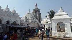
Nilamadhav Temple at Kantilo | |
 Kantilo  Kantilo Location in Odisha, India | |
| Coordinates: 20°21′N 85°11′E / 20.35°N 85.18°ECoordinates: 20°21′N 85°11′E / 20.35°N 85.18°E | |
| Country |
|
| State | Odisha |
| District | Nayagarh |
| Elevation | 65 m (213 ft) |
| Population (2001) | |
| • Total | 8,727 |
| Languages | |
| • Official | Oriya |
| Time zone | IST (UTC+5:30) |
| Vehicle registration | OD |
| Website |
odisha |
Kantilo is a census town in Nayagarh district in the Indian state of Odisha. Kantilo is 100 km from its state capital Bhubaneswar and 33 km from district headquarters Nayagarh. Kantilo is famous for bell metal utensil, but nowadays it is losing its sheen.[1]
Geography
Kantilo is located at 20°21′N 85°11′E / 20.35°N 85.18°E.[2] It has an average elevation of 65 metres (213 feet). Basically a tropical climate is shown here.Temperature varies from 15 °C to 40 °C.
Demographics
As of 2001 India census,[3] Kantilo had a population of 8728. Males constitute 51% of the population and females 49%. Kantilo has an average literacy rate of 72%, higher than the national average of 59.5%: male literacy is 80%, and female literacy is 64%. In Kantilo, 11% of the population is under 6 years of age.
Places of interest
- Nilamadhav Temple , Narayani Temple, Largest coast of Mahanadi
| Name | Famous For |
|---|---|
| Sidhamula | Gokulananda Tourism Center |
| Sarankul | Ladukeswar Temple |
| Odagaon | Raghunath Temple |
| Dutikeswar | Shiv Temple |
| Dashapalla | Kuanria Dam |
| Ranapur | Maninageswari Temple |
| Satokasia | Sanctuary |
| Baisipalli | Sanctuary |
Language
Oriya
References
- ↑ Bell metal craft losing its sheen
- ↑ Falling Rain Genomics, Inc - Kantilo
- ↑ "Census of India 2001: Data from the 2001 Census, including cities, villages and towns (Provisional)". Census Commission of India. Archived from the original on 2004-06-16. Retrieved 2008-11-01.