Kapelle
For other uses, see Kapelle (disambiguation).
| Kapelle | |||
|---|---|---|---|
| Municipality | |||
|
Kapelle town centre | |||
| |||
.svg.png) Location in Zeeland | |||
| Coordinates: 51°29′N 3°57′E / 51.483°N 3.950°ECoordinates: 51°29′N 3°57′E / 51.483°N 3.950°E | |||
| Country | Netherlands | ||
| Province | Zeeland | ||
| Government[1] | |||
| • Body | Municipal council | ||
| • Mayor | Anton Stapelkamp (ChristianUnion) | ||
| Area[2] | |||
| • Total | 49.63 km2 (19.16 sq mi) | ||
| • Land | 37.13 km2 (14.34 sq mi) | ||
| • Water | 12.50 km2 (4.83 sq mi) | ||
| Elevation[3] | 1 m (3 ft) | ||
| Population (May 2014)[4] | |||
| • Total | 12,522 | ||
| • Density | 337/km2 (870/sq mi) | ||
| Demonym(s) | Kapellenaar | ||
| Time zone | CET (UTC+1) | ||
| • Summer (DST) | CEST (UTC+2) | ||
| Postcode | 4420–4429 | ||
| Area code | 0113 | ||
| Website |
www | ||
_huizen_op_kerkplein.JPG)

Kapelle (![]() pronunciation ) is a municipality and a town in the southwestern Netherlands on Zuid-Beveland.
pronunciation ) is a municipality and a town in the southwestern Netherlands on Zuid-Beveland.
Population centers
- Biezelinge
- Eversdijk
- Kapelle
- Schore
- Wemeldinge
Topography
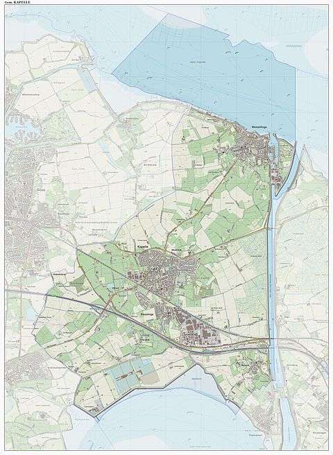
Dutch Topographic map of the municipality of Kapelle, June 2015.
Transport
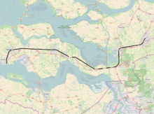
Passenger railway Vlissingen to Roosendaal (part of line 11), with stations (grouped by municipality, bolded), and official station abbreviations:
- Vlissingen (vs)
- Vlissingen Souburg (vss)
- Middelburg (mdb)
- Arnemuiden (arn)
- Goes (gs)
- Kapelle-Biezelinge (bzl)
- Kruiningen-Yerseke (krg) (mun. Reimerswaal)
- Krabbendijke (kbd)
- Rilland-Bath (rb)
- Bergen op Zoom (bgn)
- Roosendaal (rsd)
Famous people
- Annie M.G. Schmidt - famous writer was born in Kapelle
- Jan Kees de Jager - former Dutch minister of Finance
International relations
Twin towns — Sister cities
Kapelle is twinned with:
-
 Skoczów, Poland
References
- ↑ "Samenstelling" [Members] (in Dutch). Gemeente Kapelle. Retrieved 11 December 2013.
- ↑ "Kerncijfers wijken en buurten" [Key figures for neighbourhoods]. CBS Statline (in Dutch). CBS. 2 July 2013. Retrieved 12 March 2014.
- ↑ "Postcodetool for 4421AA". Actueel Hoogtebestand Nederland (in Dutch). Het Waterschapshuis. Retrieved 11 December 2013.
- ↑ "Bevolkingsontwikkeling; regio per maand" [Population growth; regions per month]. CBS Statline (in Dutch). CBS. 26 June 2014. Retrieved 24 July 2014.
External links
 Media related to Kapelle, Zeeland at Wikimedia Commons
- Official website
 |
Tholen Eastern Scheldt |
| ||
| Goes | |
|||
| ||||
| | ||||
| Borsele | Western Scheldt Hulst |
Reimerswaal |
Municipalities of Zeeland | ||
|---|---|---|
 | ||
| ||
This article is issued from Wikipedia - version of the 1/31/2016. The text is available under the Creative Commons Attribution/Share Alike but additional terms may apply for the media files.