Karauli
| Karauli | |
|---|---|
| city | |
 Karauli  Karauli Location in Rajasthan, India | |
| Coordinates: 26°30′N 77°01′E / 26.5°N 77.02°ECoordinates: 26°30′N 77°01′E / 26.5°N 77.02°E | |
| Country |
|
| State | Rajasthan |
| District | Karauli |
| Founded by | Raja Bijaipal |
| Government | |
| • Body | Nagar Palika |
| Elevation | 275 m (902 ft) |
| Population (2011) | |
| • Total | 82,960 |
| Languages | |
| • Official | Hindi |
| Time zone | IST (UTC+5:30) |
| PIN | 322241 |
| Vehicle registration | RJ 34 |
| Website |
www |
Karauli (also formerly spelled Karoli or Kerowlee) is a town located in the Indian state of Rajasthan. The town is the administrative center of Karauli District, and was formerly the capital of the erstwhile princely state of Karauli.
Geography
Karauli is located at 26°30′N 77°01′E / 26.5°N 77.02°E.[1] It has an average elevation of 275 metres (902 ft).
History
Earlier, Karauli, along with Alwar, was part of the Matsya kingdom, according to the legend of Mahabharata. The modern princely state Karauli was founded in about 995 by Raja Bijai Pal,who was a Jadon Rajput[2][3][4] [5] ruler, who is 88th in descent from the Hindu god Krishna. The Chandravanshi Yaduvanshi Jadon Rajputs are descendants of the preceding Mathura Kingdom, founded in 900AD by Raja Brahm Pal. The town itself dates from 1348, and is located in a geographical setting naturally defended by ravines on the north and east, and is further protected by a great wall. His Highness the Maharaja maintains a military force of 281 cavalry, 1640 infantry, and 56 guns, and is entitled to a salute of 17 guns (as of 1892). The Britishers later occupied it, and they ruled up to 1947. The Maharaja's palace is a handsome block of buildings, some of them dating to the late 18th century. Karauli State was founded by Maharaja Arjun Dev pal in 1346 AD, but now the Gurjar and Meena castes dominate Karauli. लेखक:- क्षत्रिय यदुवंशी कुँवर अभय प्रताप सिंह जादौन.[6]
Geographical
Area - 674 km2
Longitude - 760 37’ E to 770 13’ E
Latitude - 260 2’ N to 260 21’ N
Highest Point - 475 m
Climate
Subtropical, dry climate with distinct winter, summer and monsoon.
Highest Temperature - 49.0C (May–June)
Lowest Temperature - 5.0 C (January)
Average Rainfall - 800 mm
Monsoon - July to September ( Visit Season )
Monuments
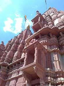
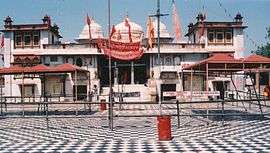
Kaila Devi (Goddess) temple is located on the banks of the Kalisil river in Karauli district. The temple is devoted to the tutelary deity, goddess Kaila, of the erstwhile princely rulers of the Karauli state. It is marble structures with a large courtyard of a checkered floor.In one place are a number of red flags planted by devotees. The place is also famous for its fair held during the dark half of Chaitra (March–April), which lasts for a fortnight.The priests of this famous temple belongs to Meena caste of Rajasthan who were the rulers of Matsya kingdom.
Kaila Devi Shrine is located near Karauli. Karauli is a holy city situated 160 km from Jaipur and 103 km from Sawai Madhopur, is venue for the famous Kaila Devi fair. Earlier called Kalyanpuri, after the local deity Kalyanji, Karauli was founded in 1348 A.D. Karauli was strongly fortified by its rulers. The city is surrounded by a wall of red sandstone strengthened by bastions at several places. The peripheral wall, now dilapidated at several places, has six gates and eleven posterns. Raja Gopal Das of Karauli ruled from 1533 to 1569. During this time, he defeated Daud Khan. To acknowledge his valorous deeds, the Mughal Emperor, Akbar, bestowed on him the award of Ranjit Nagarah which is still with the erstwhile rulers. As per the legends, the ruling family of Karauli, recognised as the head of the Yadhuvanshi Rajputs, are the descendants of Lord Krishna. Situated 23 km. from Kaila Devi, Karauli was an erstwhile princely state in eastern Rajasthan. Karauli is famous for its pale red-stone. Karauli has some noted places of visits like temples of Kaila Devi and Madan Mohanji and other historic monuments.
In the sanctum sanctorum, there are two idols. The idol of Kaila Devi is slightly reclined as the neck of the goddess is bend. The idols are very old and they are made of the locally available stone. Shakta sect holds way of the temple but it is worshiped by all Hindus and all others. The temple is a fine example of medieval architecture. The shikhar is very high, like a pyramid. There is an open court. The Jagmohan or the prayer hall is also the same. The ornamental work, engraving and encarving have been done on walls and pillars. The temple stands on a rocky elevation. The shikhar can be seen from a distance. The Jagmohan of the temple is spacious.
The temple has a strong hold on peoples' faith. The village was named Kaila after a sadhu called Kedar Giri who lived on the banks of the river Kalisil. The temple of Kaila Devi is located on the banks of the Kalisil river in the hills of Trikut, 2 km. to the north-west of Kaila village. Kaila Devi has been regarded as the guardian deity throughout the ages by the Khinchis, the Yadavas and the princess of Karauli.
It is a marble structure with a large courtyard of a checkered floor. In one place are a number of red flags planted by devotees. The place is also famous for its fair held during the dark half of ‘chaitra’(March–April) and lasts for a fortnight.
Demographics
As of 2011 India census,[7] Karauli had a population of 82,960. Males constitute 53% of the population and females 47%. Karauli has an average literacy rate of 53%, lower than the national average of 59.5%. Male literacy is 65%, and female literacy is 41%. In Karauli, 19% of the population is under 6 years of age.
References
- ↑ "Maps, Weather, and Airports for Karauli, India".
- ↑ An ethnographical hand-book for the N.-W. provinces and Oudh By William Crooke
- ↑ An Ethnographical Hand-book for the N.-W. Provinces and Oudh.
- ↑ A History of the Sikhs from the Origin of the Nation to the Battles of the ...
- ↑ Cunningham, Joseph Davey; Garrett, H. L. O. A History of the Sikhs from the Origin of the Nation to the Battles of the Sutlej. Asian Educational Services. p. 7. ISBN 9788120609501. Retrieved 24 April 2016.
- ↑ Abhinay Rathore. "History of Jadons". Rajput Provinces of India.
- ↑ "Karauli District Population Census 2011, Rajasthan literacy sex ratio and density".
External links
| Wikivoyage has a travel guide for Karauli. |
- Karauli founded by Maharaja Arjun Dev Pal
- Most of the population migrate from Karauli
- Karauli District website
- Genealogy of the ruling chiefs of Karauli
![]() This article incorporates text from a publication now in the public domain: Chisholm, Hugh, ed. (1911). "article name needed". Encyclopædia Britannica (11th ed.). Cambridge University Press.
This article incorporates text from a publication now in the public domain: Chisholm, Hugh, ed. (1911). "article name needed". Encyclopædia Britannica (11th ed.). Cambridge University Press.
| Outline | 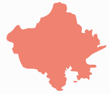 | ||||||||||||||||||||||||||
|---|---|---|---|---|---|---|---|---|---|---|---|---|---|---|---|---|---|---|---|---|---|---|---|---|---|---|---|
| Governance | |||||||||||||||||||||||||||
| Divisions and Districts |
| ||||||||||||||||||||||||||
| Major cities | |||||||||||||||||||||||||||
| Related templates |
| ||||||||||||||||||||||||||