Karlovac County
| Karlovac County Karlovačka županija | |||
|---|---|---|---|
| County | |||
| |||
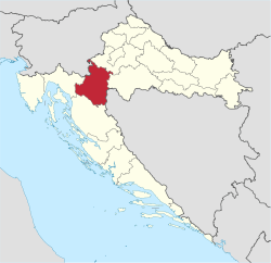 Karlovac County within Croatia | |||
| Country | Croatia | ||
| County seat | Karlovac | ||
| Government | |||
| • Župan | Ivan Vučić (HDZ) | ||
| Area[1] | |||
| • Total | 3,626 km2 (1,400 sq mi) | ||
| Population (2011)[2] | |||
| • Total | 128,899 | ||
| • Density | 36/km2 (92/sq mi) | ||
| Area code | 047 | ||
| ISO 3166 code | HR-04 | ||
| Website | http://www.kazup.hr/ | ||
Karlovac County (Croatian: Karlovačka županija) is a county in central Croatia, with the administrative center in Karlovac.
The city of Karlovac is another fort from the times of the Military Frontier. It was built as a six-side star fort in the 16th century at the point of confluence of four rivers. The town blossomed in the 18th and the 19th century after being made a free town, with the development of roads between Pannonian plains to the seaside, and waterways along the Kupa river. The city is making use of its crucial geostrategic point in Croatia.
The county itself extends towards the north to the water springs of Jamnica, and towards the south all the way down to the mountainous regions of Gorski kotar and Lika, in particular to the Bjelolasica mountain which features the largest winter sport recreation center in the country.
Administrative division
Karlovac County is divided:
- City of Karlovac
- Town of Duga Resa
- Town of Ogulin
- Town of Ozalj
- Town of Slunj
- Municipality of Barilović
- Municipality of Bosiljevo
- Municipality of Cetingrad
- Municipality of Draganić
- Municipality of Generalski Stol
- Municipality of Josipdol
- Municipality of Kamanje
- Municipality of Krnjak
- Municipality of Lasinja
- Municipality of Netretić
- Municipality of Plaški
- Municipality of Rakovica
- Municipality of Ribnik
- Municipality of Saborsko
- Municipality of Tounj
- Municipality of Vojnić
- Municipality of Žakanje
Demographics
| Historical populations of Karlovac County | |||||||||||||||||||||||||||||||||||||||||||||||||||||||
|---|---|---|---|---|---|---|---|---|---|---|---|---|---|---|---|---|---|---|---|---|---|---|---|---|---|---|---|---|---|---|---|---|---|---|---|---|---|---|---|---|---|---|---|---|---|---|---|---|---|---|---|---|---|---|---|
|
| ||||||||||||||||||||||||||||||||||||||||||||||||||||||
| Source: Naselja i stanovništvo Republike Hrvatske 1857–2001, Croatian Bureau of Statistics, Zagreb, 2005 | |||||||||||||||||||||||||||||||||||||||||||||||||||||||
As of the 2011 census, the county had 128,899 residents. The population density is 36 people per km².
Ethnic Croats form the majority with 86.1% of the population, followed by Serbs at 10.4%.[3]
References
- ↑ Ostroški, Ljiljana, ed. (December 2015). Statistički ljetopis Republike Hrvatske 2015 [Statistical Yearbook of the Republic of Croatia 2015] (PDF). Statistical Yearbook of the Republic of Croatia (in Croatian and English). 47. Zagreb: Croatian Bureau of Statistics. p. 62. ISSN 1333-3305. Retrieved 27 December 2015.
- ↑ "Population by Ethnicity, by Towns/Municipalities, 2011 Census". Census of Population, Households and Dwellings 2011. Zagreb: Croatian Bureau of Statistics. December 2012.
- ↑ "Stanovništvo prema narodnosti po gradovima/općinama, Popis 2011.". Croatian Bureau of Statistics. Retrieved 4 December 2014.
External links
- Official website (Croatian)
| Wikimedia Commons has media related to Karlovac County. |
Subdivisions of Karlovac County | ||
|---|---|---|
| Cities and towns |  | |
| Municipalities | ||
Coordinates: 45°29′35″N 15°33′21″E / 45.49306°N 15.55583°E