Karlstein an der Thaya
| Karlstein an der Thaya | ||
|---|---|---|
 | ||
| ||
 Karlstein an der Thaya Location within Austria | ||
| Coordinates: 48°53′00″N 15°24′00″E / 48.88333°N 15.40000°ECoordinates: 48°53′00″N 15°24′00″E / 48.88333°N 15.40000°E | ||
| Country | Austria | |
| State | Lower Austria | |
| District | Waidhofen an der Thaya | |
| Government | ||
| • Mayor | Ernst Herynek (ÖVP) | |
| Area | ||
| • Total | 48.86 km2 (18.86 sq mi) | |
| Elevation | 442 m (1,450 ft) | |
| Population (1 January 2016)[1] | ||
| • Total | 1,497 | |
| • Density | 31/km2 (79/sq mi) | |
| Time zone | CET (UTC+1) | |
| • Summer (DST) | CEST (UTC+2) | |
| Postal code | 3822 | |
| Area code | 02844 | |
| Vehicle registration | WT | |
| Website | www.karlstein-thaya.gv.at | |

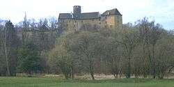
Karlstein an der Thaya is a municipality in the district of Waidhofen an der Thaya in the Austrian state of Lower Austria.
Population
| Historical population | ||
|---|---|---|
| Year | Pop. | ±% |
| 1971 | 1,948 | — |
| 1981 | 1,723 | −11.6% |
| 1991 | 1,596 | −7.4% |
| 2001 | 1,586 | −0.6% |
References
External links
| Wikimedia Commons has media related to Karlstein an der Thaya. |
This article is issued from Wikipedia - version of the 12/13/2014. The text is available under the Creative Commons Attribution/Share Alike but additional terms may apply for the media files.