Kaskaskia, Illinois
| Kaskaskia | |
| Village | |
 Kaskaskia Church | |
| Country | United States |
|---|---|
| State | Illinois |
| County | Randolph |
| Coordinates | 37°55′17″N 89°54′59″W / 37.92139°N 89.91639°WCoordinates: 37°55′17″N 89°54′59″W / 37.92139°N 89.91639°W |
| Area | 0.11 sq mi (0 km2) |
| - land | 0.11 sq mi (0 km2) |
| - water | 0.00 sq mi (0 km2) |
| Population | 14 (2010) |
| Timezone | CST (UTC-6) |
| - summer (DST) | CDT (UTC-5) |
| Postal code | 63673 |
| Area code | 618/366 |
  Location of Kaskaskia within Illinois
| |
| Wikimedia Commons: Kaskaskia, Illinois | |
Kaskaskia is a historically important village in Randolph County, Illinois, United States. In the 2010 census the population was 14, making it the second-smallest incorporated community in the State of Illinois in terms of population, behind Valley City (pop. 13).[1] As a major French colonial town of the Illinois Country, in the 18th century its peak population was about 7,000, when it was a regional center. During the American Revolutionary War, the town, which by then had become an administrative center for the British Province of Quebec, was taken by the Virginia militia during the Illinois campaign. It was designated as the county seat of Illinois County, Virginia, after which it became part of the Northwest Territory in 1787. Kaskaskia was later named as the capital of the United States' Illinois Territory, created on February 3, 1809. In 1818, when Illinois became the 21st U.S. state, the town briefly served as the state's first capital until 1819, when the capital was moved to Vandalia.
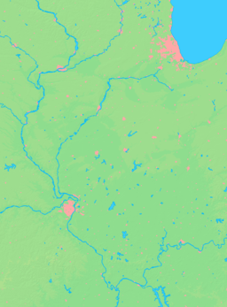
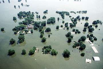
Most of the town was destroyed in April 1881 by flooding, as the Mississippi River shifted eastward to a new channel, taking over the lower 10 mi (16 km) of the Kaskaskia River. This resulted from deforestation of the river banks during the 19th century, due to crews taking wood for fuel to feed the steamboat and railroad traffic. The river now passes east rather than west of the town. The state boundary line, however, remained in its original location. Accordingly, if the Mississippi River is considered to be a break in physical continuity, Kaskaskia is an exclave of Illinois, lying west of the Mississippi and accessible only from Missouri. A small bridge crosses the old riverbed, now a creek that is sometimes filled with water during flood season. Kaskaskia has an Illinois telephone area code (618) and a Missouri ZIP Code (63673). Its roads are maintained by Illinois Dept. of Transportation, and its few residents vote in the Illinois elections. The town was evacuated in the Great Flood of 1993, which covered it with water more than nine feet deep.
In 2010, How the States Got Their Shapes on the History Channel featured Kaskaskia. The former Randolph County Sheriff was featured discussing different sites on Kaskaskia Island.
History
The site of Kaskaskia near the river was first a Native American village, inhabited by varying indigenous peoples for thousands of years. The historic Illini peoples lived in this area at the time of European encounter and traded with the French colonists.
French colonists named the town after the Illini word for the Kaskaskia River but, historically, it was referred to as Kasklas, Kaskasky, Cas-caskias, Kasquskias, and Kaskaskias, with many spelling variations. In 1703, French Jesuit missionaries established a mission with the goal of converting the Illini Native Americans to Catholicism. The congregation built its first stone church in 1714. The French also had a fur trading post in the village.[2] Canadien settlers moved in to farm and to exploit the lead mines on the Missouri side of the river.
Favorably situated on a peninsula on the east side of the Mississippi River, Kaskaskia became the capital of Upper Louisiana and the French built Fort de Chartres nearby in 1718. In the same year they imported the first enslaved Africans, shipped from Santo Domingo in the Caribbean, to work as laborers in the lead mines being developed in Missouri.[3][4]
From the years of early French settlement, Kaskaskia was a multicultural village, consisting of a few French men and numerous Illinois and other American Indians. In 1707, the population of the community was estimated at 2,200, the majority of them Illinois who lived somewhat apart from the Europeans. Writing of Kaskaskia about 1715, a visitor said that the village consisted of 400 Illinois men, "good people;" two Jesuit missionaries, and "about twenty French voyageurs who have settled there and married Indian women."[5] Of 21 children whose birth and baptism was recorded in Kaskaskia before 1714, 18 had mothers who were Indian and 20 had fathers who were French. One devout Catholic full-blooded Indian woman disowned her half-breed son for living "among the savage nations," as she referred to the French.[6]
Many of the Canadiens and their mixed-race descendants at Kaskaskia became voyageurs and coureurs des bois, who would explore and exploit the Missouri River country for fur trading. The Canadiens had the goal of trading with all the Prairie tribes, and beyond them, with the Spanish colony in New Mexico. The Spanish intended to keep control of the latter trade. The Canadien goals stimulated the expedition of Claude Charles Du Tisne to establish trade relations with the Plains Indians in 1719.
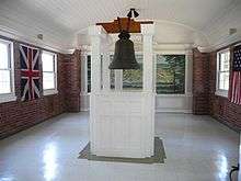
King Louis XV sent a bell to Kaskaskia in 1741 for its church, one of several constructed there.[7] During the years of French rule, Kaskaskia and the other agricultural settlements in the Illinois Country were critical for supplying Lower Louisiana, especially New Orleans, with wheat and corn, as these staple crops could not be grown in the Gulf climate. Farmers shipped tons of flour south over the years, which helped New Orleans survive.
In 1733, the French built Fort Kaskaskia near this site. It was destroyed by the British in 1763 during the French and Indian War (also known as the Seven Years' War), which they won. Rather than live under British rule after France ceded the territory east of the river, many French-speaking people from Kaskaskia and other colonial towns moved west of the Mississippi to Ste. Genevieve, St. Louis, and other areas.
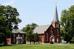
During one of the westernmost military campaigns of the American Revolution, the city fell on July 4, 1778 to George Rogers Clark and his force of 200 men, including Captains Joseph Bowman and Leonard Helm. The parish rang the church bell in celebration, and it has since been called the "liberty bell". The brick church was built in 1843 in the squared-off French style and later moved to the restored village of Kaskaskia.[7]

As a center of the regional economy, Kaskaskia served as the capital of Illinois Territory from 1809 until statehood was gained in 1818, and then as the state capital until 1819. The first Illinois newspaper, the Illinois Herald, was published here on June 24, 1814.[8]
The city's peak population was about 7,000, before the capital was moved in 1819 to Vandalia. Although the introduction of steamboats on the Mississippi River stimulated the economies of river towns, in the 19th century, their use also had devastating environmental effects. Deforestation of the river banks followed steamboat crews' regular cutting of trees, which were used to feed the engine boiler fires as fuel to power the steamboats. River banks, through rapid, man-made erosion, became unstable, causing massive amounts of soil to collapse into the flowing water.[9]
From St. Louis to the confluence of the Ohio River, the Mississippi became wider and more shallow, resulting in more severe seasonal flooding. In the late 19th century, the town was cut off from the Illinois mainland and mostly destroyed by repeated flooding and a channel change by the Mississippi River. Much of the former property of Kaskaskia and other French colonial towns on the river has been lost.[9] Following the Great Flood of 1844, residents of Kaskaskia relocated the town to the south. The original location of Kaskaskia became an island, surrounded by the Mississippi River. The flood of 1881 destroyed all remnants of the original town and the Mississippi shifted into the channel of the Kaskaskia River, passing east instead of west of the town.
Parts of the town were rebuilt in the new area. As the Mississippi continued to flow through its new bed, earth was deposited so that the village land became physically attached to the west bank of the river, which primarily lies within the boundaries of the state of Missouri. Now a bayou, the old channel is regularly flooded by the river. A small bridge carries traffic from the mainland over the bayou to Kaskaskia and its surrounding farmlands in the floodplain. A levee lines the river to the east. In 1893 the people of the town moved and rebuilt the Church of the Immaculate Conception at Kaskaskia. They also built a shrine in a similar style nearby to house the "liberty bell."[7]
By 1950, only 112 people lived in Kaskaskia. By 1970, the population had fallen to 79, and it continued its precipitous decline to 33 in 1980. The town was submerged under nine feet of water by the Great Flood of 1993, which reached the roofs of the buildings. By 2000, with nine residents, Kaskaskia was almost a ghost town, the least populous incorporated community in the State of Illinois.
Geography

Kaskaskia is located at 37°55′17″N 89°54′59″W / 37.921395°N 89.916467°W.[10] According to the 2010 census, Kaskaskia has a total area of 0.11 square miles (0.28 km2), all land.[11] However, the village comprises only a small part of Kaskaskia Precinct, which includes all of Randolph County's land west of the Mississippi. The precinct forms an exclave of Illinois within Missouri. Kaskaskia Precinct has a land area of 24.037 sq mi (62.256 km2) and a 2000 census population of 36 people. In 1993 the Mississippi River almost completely flooded the island.
Demographics
| Historical population | ||
|---|---|---|
| Year | Pop. | ±% |
| 1818 | 7,267 | — |
| 1900 | 177 | −97.6% |
| 1910 | 142 | −19.8% |
| 1920 | 152 | +7.0% |
| 1930 | 107 | −29.6% |
| 1940 | 131 | +22.4% |
| 1950 | 112 | −14.5% |
| 1960 | 97 | −13.4% |
| 1970 | 79 | −18.6% |
| 1980 | 33 | −58.2% |
| 1990 | 32 | −3.0% |
| 2000 | 9 | −71.9% |
| 2010 | 14 | +55.6% |
| 2014 | 20 | +42.9% |
| 2015 | 13 | −35.0% |
Source: [13] | ||
As of the census[14] of 2000, there were 9 people, 4 households, and 3 families residing in the village. The population density was 83.0/sq mi (32.0/km2). There were 5 housing units at an average density of 46.1/sq mi (17.8/km2). The racial makeup of the village was 7 White, 1 Pacific Islander, 1 from other races. There were 2 Hispanics or Latinos of any race.
There were four households, none of which had children under the age of 18 living with them. Two were married couples living together, one had a female householder with no husband present, and one was a non-family. One household was made up of individuals, and one had someone living alone who was 65 years of age or older. The average household size was 2.25 and the average family size was 2.67.
In the village two people were under the age of 18, both girls. There was one person from 18 to 24, one from 25 to 44, two from 45 to 64, and three who were 65 years of age or older. The median age was 48 years. There were seven females and two males.
Notable people
- David J. Baker, United States senator
- David J. Baker, Jr., Chief Justice of the Illinois Supreme Court
- Shadrach Bond, the first Governor of Illinois
- John Duff, outlaw and Revolutionary War soldier; scout and sergeant under George Rogers Clark
- Thomas Duncan, general during the American Civil War
- John Edgar, businessman and legislator
- George Fisher, pioneer, physician, and legislator[15]
- John Rice Jones, jurist and politician
- Samuel Judy, pioneer and legislator[16]
- Lucien Maxwell, rancher
- John Willis Menard, the first African American elected to the United States Congress
- James L. D. Morrison, Mexican War officer, U.S. Representative, gubernatorial candidate
See also
References
- ↑ "American FactFinder". U.S. Census Bureau. Retrieved 4 March 2011.
- ↑ "Father William Faherty Papers", Symposium 2001, National Park Service, accessed 14 April 2010
- ↑ Wedel, Mildred Mott (Fall 1972). "Claude-Charles Dutisne: A Review of His 1719 Journeys". Great Plains Journal. 12 (1): 4–25.
- ↑ Wedel, Mildred Mott (Winter 1973). "Claude-Charles Dutisne: A Review of His 1719 Journeys". Great Plains Journal. 12 (2): 147–173.
- ↑ Norall, Frank. Bourgmont, Explorer of the Missouri, 1698-1725. Lincoln: University of Nebraska Press, 1988. p. 107
- ↑ Ekberg, Carl J. French Roots in the Illinois Country: The Mississippi Frontier in Colonial Times, Chicago: University of Illinois Press, 2000. pp. 153-154
- 1 2 3 "Visitors' Guide: Immaculate Conception Church", Great River Road, accessed November 9, 2009
- ↑ "Anniversaries in 1949 of Events Recorded in The Missourian Files". Southeast Missouri. Cape Girardeau, Missouri. January 29, 1949.
- 1 2 F. Terry Norris, "Where Did the Villages Go? Steamboats, Deforestation, and Archaeological Loss in the Mississippi Valley", in Common Fields: An Environmental History of St. Louis, Andrew Hurley, ed., St. Louis, MO: Missouri Historical Society Press, 1997, pp. 73-89
- ↑ "US Gazetteer files: 2010, 2000, and 1990". United States Census Bureau. 2011-02-12. Retrieved 2011-04-23.
- ↑ "G001 - Geographic Identifiers - 2010 Census Summary File 1". United States Census Bureau. Retrieved 2015-08-04.
- ↑ "Census of Population and Housing". Census.gov. Archived from the original on May 11, 2015. Retrieved June 4, 2015.
- ↑ "Annual Estimates of the Resident Population for Incorporated Places: April 1, 2010 to July 1, 2014". Retrieved June 4, 2015.
- ↑ "American FactFinder". United States Census Bureau. Retrieved 2008-01-31.
- ↑ 'Historical Encyclopedia of Illinois,' vol. 1, Newton Bates-editor, Munsell Printing Company, pg. 166
- ↑ 'Historical Encyclopedia of Illinois,' vol. 1 Newton Bateman-editor, Munsell Printing Company, pg. 312
- Kaskaskia village and Kaskaskia precinct, Randolph County, Illinois United States Census Bureau
External links
| Wikimedia Commons has media related to Kaskaskia, Illinois. |
- "Images -Kaskaskia, IL", Computer Chair Traveler
- "Immaculate Conception Church on Kaskaskia Island", GuidepostUSA
- "Kaskaskia Bell State Historic Site", GuidepostUSA
- Stead v. Commons of Kaskaskia, 1 Scam. 239 (1909)
- "Curse of Kaskaskia". Prairie Ghosts
Municipalities and communities of Randolph County, Illinois, United States | ||
|---|---|---|
| Cities | ||
| Villages | ||
| Precincts | ||
| Unincorporated communities | ||