Henryków Lubański
| Henryków Lubański | |
|---|---|
| Village | |
 | |
 Henryków Lubański | |
| Coordinates: 51°10′N 15°16′E / 51.167°N 15.267°E | |
| Country |
|
| Voivodeship | Lower Silesian |
| County | Lubań |
| Gmina | Gmina Lubań |
| Population | 850 |
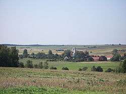
Henryków Lubański [xɛnˈrɨkuf luˈbaɲski] (German: Katholisch Hennersdorf) is a village in the administrative district of Gmina Lubań, within Lubań County, Lower Silesian Voivodeship, in south-western Poland.[1] It lies approximately 7 kilometres (4 mi) north-west of Lubań, and 124 kilometres (77 mi) west of the regional capital Wrocław. The village has a population of 850.

The village contains Poland's oldest tree – a 1260-year-old yew, which is listed as a natural monument.
Hennersdorf belonged to the historic Upper Lusatia region, a Bohemian crown land, and was a possession of the Magdalene Abbey at Lauban (Lubań). It remained Catholic, when the region turned Protestant in the early 16th century and even after the Lusatias passed to Saxony by the 1635 Peace of Prague. In 1745, the village was the site of the Battle of Hennersdorf between the Prussian Army under General Hans Joachim von Zieten and a Saxon contingent in the War of the Austrian Succession. Upon the implementation of the Oder-Neisse line in 1945, the region became part of the Republic of Poland in 1945. Following World War II the native German populace was expelled and replaced mostly by Poles expelled by Soviets from eastern borderlands of Second Polish Republic after 1944.
The St. Nicholas Church is a stop on the Lower Silesian route of the Way of St. James.
External links
- (Polish) Henryków yew at Gmina Lubań
Sources
| Villages | ||
|---|---|---|
| Seat (not part of the gmina) | ||
Coordinates: 51°10′N 15°16′E / 51.167°N 15.267°E