Kayak Island
|
Bering Expedition Landing Site | |
 | |
| Location | Katalla, Alaska |
|---|---|
| Coordinates | 59°56′03″N 144°22′06″W / 59.93417°N 144.36833°WCoordinates: 59°56′03″N 144°22′06″W / 59.93417°N 144.36833°W |
| Built | 1741 |
| NRHP Reference # | 77001542 |
| Significant dates | |
| Added to NRHP | July 20, 1977[1] |
| Designated NHL | June 2, 1978[2] |
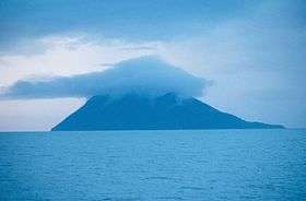
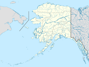
Kayak Island (59°56′03″N 144°22′06″W / 59.93417°N 144.36833°W), which includes the Bering Expedition Landing Site, is located in the Gulf of Alaska, 100 km (62 mi) SE of Cordova, Alaska Malaspina Coastal Plain, on the eastern edge of Chugach National Forest. It has a land area of 73.695 km² (28.454 sq mi) and no population.
It was named "Kayak" in 1826 by Lt. Sarichef of the Russian Navy, because of the fancied resemblance of its outline to the Eskimo skin canoe. This island, it is believed, was the one Vitus Bering saw and named "Saint Elias" in 1741.
According to the National Park Service, "Here naturalist Georg W. Steller, surgeon aboard Vitus Bering's ST. PETER, made the first attempts at contact between Europeans and Alaskan natives. His investigations are among the first contributions to the West's knowledge of the natural and human history of the region."[2]
Captain James Cook visited the island on May 12, 1778, and buried a bottle with a paper and two small pieces of silver given to him by Dr. Richard Kaye, the chaplain of King George III, for this purpose. Because of this, Capt. Cook gave the name "Kaye's Island" to this feature. The 1779 expedition of Spanish explorer Ignacio de Arteaga y Bazán sighted the island about July 16, the feast day of Our Lady of Mt. Carmel (or Carmen), and so named it "Nuestra Senora del Carmen" or "Isla del Carmen."
The Bering Expedition Landing Site was declared a National Historic Landmark in 1978.[2][3]
Cape Saint Elias is located on the southwest end of the island. Mount Saint Elias — about 115 miles to the ENE, and at 18,009 feet (5,489 m) the second highest mountain in both the United States and Canada — was likely named after this cape.
The Cape St. Elias Light is an important aid-to-navigation located on the island.
See also
- List of National Historic Landmarks in Alaska
- National Register of Historic Places listings in Valdez-Cordova Census Area, Alaska
References
- ↑ National Park Service (2007-01-23). "National Register Information System". National Register of Historic Places. National Park Service.
- 1 2 3 "Bering Expedition Landing Site". National Historic Landmark summary listing. National Park Service. Retrieved 2007-11-19.
- ↑ William S. Hanable (January 15, 1976). "National Register of Historic Places Inventory-Nomination: Bering Expedition Landing Site (AHRS SITE NO. XMI 005)" (PDF). National Park Service. and Accompanying photos, exterior and interior, from 19. (292 KB)
External links
| Wikimedia Commons has media related to Kayak Island. |
- Kayak Island: Block 1191, Census Tract 2, Valdez-Cordova Census Area, Alaska United States Census Bureau
| Topics | |
|---|---|
| Lists by states |
|
| Lists by insular areas | |
| Lists by associated states | |
| Other areas | |
| |