Keetmanshoop
| Keetmanshoop ǂNuǂgoaes Swartmodder | |||
|---|---|---|---|
| City | |||
|
Keetmanshoop church | |||
| |||
| Motto: Laborando vincimus | |||
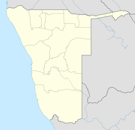 Keetmanshoop Location in Namibia | |||
| Coordinates: 26°34′43″S 18°8′0″E / 26.57861°S 18.13333°ECoordinates: 26°34′43″S 18°8′0″E / 26.57861°S 18.13333°E | |||
| Country |
| ||
| Region | ǁKaras Region | ||
| Constituency | Keetmanshoop Urban | ||
| Established | 14 April 1866 | ||
| Population (2011)[1] | |||
| • Total | 20,977 | ||
| Time zone | South African Standard Time (UTC+1) | ||
| Climate | BWh | ||


Keetmanshoop is a city[2] in the ǁKaras Region of southern Namibia, lying on the Trans-Namib Railway from Windhoek to Upington in South Africa. It is named after Johann Keetman, a German industrialist and benefactor of the city.
The town is situated in a semi-arid area, normally receiving an annual average rainfall of only 152 millimetres (6.0 in), although in the 2010/2011 rainy season 254 millimetres (10.0 in) were measured.[3]
History
Before the colonial era, the settlement was known as ǂNuǂgoaes or Swartmodder, both of which mean "Black Marsh" and indicated the presence of a spring in the area. The first white settler, Guilliam Visagie, arrived here in 1785.[4] When in February 1850 the Kharoǃoan clan (Keetmanshoop Nama) split from the Red Nation, the main subtribe of the Nama people, they settled permanently here.[5] In 1860 the Rheinische Missionsgesellschaft founded a mission there to christianize the local Nama. The first missionary, Johann Georg Schröder, arrived in Keetmanshoop on April 14, 1866, which is now marked as the founding date of Keetmanshoop. The mission station was named after the German trader and director of the Rhenish Missionary Society Johann Keetman who supported the mission financially. He never actually visited the place himself.[6]
Geography
Climate
Keetmanshoop has a hot desert climate (Köppen climate classification BWh), with long, very hot summers and warm winters. The annual average rainfall is only 159 mm (6 in). Keetmanshoop is one of the sunniest places year-round on the planet with a mean sunshine duration over 3,870 h yearly or 10.7 sunny hours daily or well above 87% of the time.[7][8] The annual mean temperature is 21.1 °C (70.0 °F) with a mean annual high of 28.8 °C (83.8 °F) and a low of 13.3 °C (55.9 °F). The climate is characterized by sunshine and dryness as well as moderate heat all year long.
| Climate data for Keetmanshoop | |||||||||||||
|---|---|---|---|---|---|---|---|---|---|---|---|---|---|
| Month | Jan | Feb | Mar | Apr | May | Jun | Jul | Aug | Sep | Oct | Nov | Dec | Year |
| Average high °C (°F) | 34.8 (94.6) |
34.0 (93.2) |
32.2 (90) |
28.8 (83.8) |
25.0 (77) |
21.7 (71.1) |
21.3 (70.3) |
23.5 (74.3) |
27.2 (81) |
30.1 (86.2) |
32.4 (90.3) |
34.5 (94.1) |
28.8 (83.8) |
| Average low °C (°F) | 19.0 (66.2) |
19.3 (66.7) |
17.8 (64) |
14.4 (57.9) |
10.4 (50.7) |
7.0 (44.6) |
6.4 (43.5) |
7.5 (45.5) |
10.7 (51.3) |
13.7 (56.7) |
15.7 (60.3) |
17.6 (63.7) |
13.3 (55.9) |
| Average precipitation mm (inches) | 24 (0.94) |
42 (1.65) |
36 (1.42) |
15 (0.59) |
5 (0.2) |
2 (0.08) |
1 (0.04) |
1 (0.04) |
3 (0.12) |
6 (0.24) |
11 (0.43) |
13 (0.51) |
159 (6.26) |
| Average relative humidity (%) | 28 | 36 | 40 | 40 | 38 | 39 | 36 | 31 | 27 | 24 | 24 | 25 | 32.3 |
| Mean monthly sunshine hours | 353 | 300 | 312 | 306 | 304 | 287 | 305 | 323 | 319 | 343 | 348 | 370 | 3,870 |
| Percent possible sunshine | 84 | 82 | 82 | 89 | 91 | 91 | 93 | 93 | 89 | 87 | 86 | 86 | 87.8 |
| Source: Tabulation of Climate Statistics for Selected Stations in Namibia | |||||||||||||
Notable buildings and structures
The Rhenish Missionary Church was erected in 1895, it now also contains a museum. It was declared an historic monument in 1978 and is a well-known landmark. Its unique combination of Gothic architecture cast in African stone makes it one of the architectural masterpieces in the country and a popular tourist attraction. Other notable buildings are the Schützenhaus (marksmen's club house, 1905–07), the railway station building (1908) and the Imperial Post Office (now the Keetmanshoop tourist information, erected in 1910.[6]
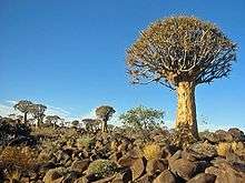
The town is situated near two quiver tree forests, one of them being a national monument and a major tourist attraction of Namibia. Also close to Keetmanshoop is the Naute Dam.
J. Stephanus Stadium is located in Keetmanshoop and is home to Fedics United F.C., a football team in the Namibia Premier League.
Keetmanshoop is also an important center of the Karakul sheep farming community.
Politics
Keetmanshoop is governed by a municipality council that currently has seven seats.[9]
Local authority results, 2010
In the 2010 local authority election, a total of 3,156 votes were cast in the city. SWAPO won with approximately 48% of the vote. Of the three other parties seeking votes in the election, RDP received approximately 35% of the vote, followed by the Democratic Party (10%) and the Democratic Turnhalle Alliance (7%).[10]
References
- ↑ "Table 4.2.2 Urban population by Census years (2001 and 2011)" (PDF). Namibia 2011 - Population and Housing Census Main Report. Namibia Statistics Agency. p. 39. Retrieved 24 August 2016.
- ↑ "Local Authorities". Association of Local Authorities in Namibia (ALAN). Retrieved 1 October 2012.
- ↑ Menges, Werner (26 May 2011). "Rainy season was one for the record books". The Namibian.
- ↑ Dierks, Klaus. "Chronology of Namibian History, 1785". Retrieved 7 July 2010.
- ↑ Dierks, Klaus (3 December 2004). "The historical role of the Nama nation". Die Republikein. Retrieved 8 July 2011.
- 1 2 von Schmettau, Konny (28 February 2013). "Aus "ǂNuǂgoaes" wird Keetmanshoop" ["ǂNuǂgoaes" becomes Keetmanshoop]. Allgemeine Zeitung (in German). Tourismus Namibia monthly supplement. p. 10.
- ↑ Thomas, David; Shaw, Paul A (1991). The Kalahari Environment. Cambridge University Press. p. 93. ISBN 0521370809.
- ↑ Rudloff (1988). World Climates. University of Michigan. p. 438. ISBN 380470509X.
- ↑ "Know Your Local Authority". Election Watch (3). Institute for Public Policy Research. 2015. p. 4.
- ↑ Local Authority Election Results for Keetmanshoop
External links
| Wikimedia Commons has media related to Keetmanshoop. |
 Keetmanshoop travel guide from Wikivoyage