Kénadsa
| Kénadsa ﻗﻨﺎدﺳﺔ | |
|---|---|
| Commune and town | |
|
Snow in Kénadsa | |
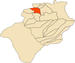 Location of Kénadsa commune within Béchar Province | |
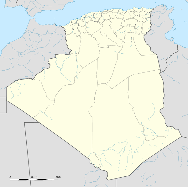 Kénadsa Location of Kénadsa within Algeria | |
| Coordinates: 31°32′N 2°25′W / 31.533°N 2.417°WCoordinates: 31°32′N 2°25′W / 31.533°N 2.417°W | |
| Country |
|
| Province | Béchar Province |
| District | Kénadsa District |
| Government | |
| • Mayor | Mohamed Metrani |
| Area[1] | |
| • Total | 2,770 km2 (1,070 sq mi) |
| Elevation | 784 m (2,572 ft) |
| Population (2008)[2] | |
| • Total | 13,492 |
| • Density | 4.9/km2 (13/sq mi) |
| Time zone | CET (UTC+1) |
.jpg)
Kénadsa is a town and commune in the Sahara Desert of south-western Algeria, and is the capital of Kénadsa District, Béchar Province. As of 2008, Kénadsa had a population of 13,492,[2] up from 11,667 in 1998,[3] and an annual growth rate of 1.5%. The commune covers an area of 2,770 square kilometres (1,070 sq mi).[1]
There is a large longwave broadcasting station near Kénadsa.
Geography
Kénadsa lies at an elevation of 784 metres (2,572 ft) on the flat rocky hamada west of Béchar. The wadi Oued Meswar is located about 6 kilometres (3.7 mi) west of the town, and meets the Oued Guir near Abadla at the locality of Ksi Ksou.
Climate
Kénadsa has a hot desert climate (Köppen: BWh),[4] with extremely hot summers and mild winters, and very little precipitation throughout the year.
| Climate data for Kénadsa | |||||||||||||
|---|---|---|---|---|---|---|---|---|---|---|---|---|---|
| Month | Jan | Feb | Mar | Apr | May | Jun | Jul | Aug | Sep | Oct | Nov | Dec | Year |
| Average high °C (°F) | 15.9 (60.6) |
19.2 (66.6) |
22.5 (72.5) |
27.1 (80.8) |
31.4 (88.5) |
36 (97) |
40.5 (104.9) |
39.4 (102.9) |
34.3 (93.7) |
27.5 (81.5) |
20.4 (68.7) |
16.8 (62.2) |
27.58 (81.66) |
| Daily mean °C (°F) | 8.9 (48) |
12 (54) |
15.4 (59.7) |
19.9 (67.8) |
24.1 (75.4) |
28.8 (83.8) |
33 (91) |
32.2 (90) |
27.4 (81.3) |
20.7 (69.3) |
14.2 (57.6) |
9.9 (49.8) |
20.54 (68.97) |
| Average low °C (°F) | 2 (36) |
4.8 (40.6) |
8.4 (47.1) |
12.7 (54.9) |
16.8 (62.2) |
21.6 (70.9) |
25.5 (77.9) |
25 (77) |
20.5 (68.9) |
14 (57) |
8 (46) |
3.1 (37.6) |
13.53 (56.34) |
| Average precipitation mm (inches) | 9 (0.35) |
8 (0.31) |
9 (0.35) |
8 (0.31) |
5 (0.2) |
4 (0.16) |
1 (0.04) |
3 (0.12) |
7 (0.28) |
12 (0.47) |
12 (0.47) |
10 (0.39) |
88 (3.45) |
| Source: Climate-Data.org, altitude: 750m[4] | |||||||||||||
Economy
Agriculture is an important industry in Kénadsa. The commune has a total of 1,850 hectares (4,600 acres) of arable land, but only 150 hectares (370 acres) is irrigated.[5] There are a total of 67,000 date palms planted in the commune.[6] As of 2009 there were 3,757 sheep, 4,592 goats, 1,507 camels, and 163 cattle. There were also 4000 chickens in 22 buildings.[7]
There is some tourism in Kénadsa; attractions include sand dunes, palm groves, the old ksar and forts, and the dam across the Oued Meswar.[8] Visitors to Kénadsa typically stay in Béchar since there are no hotels in Kénadsa.[9]
There are also bituminous coal fields near Kénadsa. They were originally discovered in 1907, but mining activity did not begin until 1917. Output peaked in the 1940s and has declined since, due to competition from oil and gas fields in eastern Algeria. There are also deposits of lead, manganese and iron ore nearby, but these are largely unused.[10]
Infrastructure and housing
100% of Kénadsa's population is connected to drinking water[11] and to the sewerage system,[12] 97% (including 2,707 buildings) have access to electricity.[13] There are two fuel service stations in the town.[14]
Kénadsa has a total of 2,613 houses, of which 2,142 are occupied, giving an occupation rate of 6.3 inhabitants per occupied building.[15]
Transportation
Kénadsa lies on a local road connecting Méridja to the west with Béchar to the east. Kénadsa is 20 kilometres (12 mi) from Béchar and 60 kilometres (37 mi) from Méridja.[16]
There is a total length of 64.4 kilometres (40.0 mi) of roads in the commune.[17]
Education
There are 4 elementary schools, with 65 classrooms including 48 in use.[18] There are a total of 2,562 school students.[19]
7.2% of the population has a tertiary education, and another 22.6% has competed secondary education.[20] The overall literacy rate is 84.6%, and is 91.2% among men and 78.2% among women.[21]
Health
Kénadsa has 5 room care facilities and a maternity ward; for other health care residents must travel to Béchar.[22]
Culture
Kénadsa has a cinema with 350 seats.[23]
Notable authors born in Kénadsa include Yasmina Khadra and Malika Mokeddem.
Religion
Kénadsa has 3 operational mosques, with another 2 under construction.[24]
Localities
The commune is composed of three localities:[25]
- Kenadsa
- Barrage Djorf Torba
- Masky
References
- 1 2 "Population, Area and Density per Commune" (in French). Official Website of the Wilaya of Bechar. Retrieved 16 March 2013.
- 1 2 "Population: Béchar Wilaya" (PDF) (in French). Office National des Statistiques Algérie. Retrieved 13 February 2013.
- ↑ "Algeria Communes". Statoids. Retrieved 9 March 2013.
- 1 2 "Climate: Kenadsa - Climate graph, Temperature graph, Climate table". Climate-Data.org. Retrieved 5 November 2013.
- ↑ "Distribution of Agricultural Land" (in French). Official Website of the Wilaya of Bechar. Retrieved 9 March 2013.
- ↑ "Plant Productions" (in French). Official Website of the Wilaya of Bechar. Retrieved 9 March 2013.
- ↑ "Animal Production" (in French). Official Website of the Wilaya of Bechar. Retrieved 9 March 2013.
- ↑ "Tourist Sites and Monuments" (in French). Official Website of the Wilaya of Bechar. Retrieved 9 March 2013.
- ↑ "Census of Hotels" (in French). Official Website of the Wilaya of Bechar. Retrieved 9 March 2013.
- ↑ "Kenadsa (town and coalfields, Algeria)". Encyclopedia Britannica. Retrieved 10 March 2013.
- ↑ "Drinking Water" (in French). Official Website of the Wilaya of Bechar. Retrieved 9 March 2013.
- ↑ "Sewerage Networks" (in French). Official Website of the Wilaya of Bechar. Retrieved 9 March 2013.
- ↑ "Electrification" (in French). Official Website of the Wilaya of Bechar. Retrieved 9 March 2013.
- ↑ "Fuel Distribution" (in French). Official Website of the Wilaya of Bechar. Retrieved 9 March 2013.
- ↑ "Housing" (in French). Official Website of the Wilaya of Bechar. Retrieved 9 March 2013.
- ↑ "Presentation" (in French). Site Officiel de la Wilaya de Béchar. Retrieved 19 February 2013.
- ↑ "Density Kilometres" (in French). Official Website of the Wilaya of Bechar. Retrieved 9 March 2013.
- ↑ "School Infrastructure" (in French). Official Website of the Wilaya of Bechar. Retrieved 9 March 2013.
- ↑ "Number of Pupils" (in French). Official Website of the Wilaya of Bechar. Retrieved 9 March 2013.
- ↑ "Structure relative de la population résidente des ménages ordinaires et collectifs âgée de 6 ans et plus selon le niveau d'instruction et la commune de résidence." (PDF) (in French). Office National des Statistiques Algérie. Retrieved 13 February 2013.
- ↑ "Taux d'analphabétisme et taux d'alphabétisation de la population âgée de 15 ans et plus, selon le sexe et la commune de résidence ." (PDF) (in French). Office National des Statistiques Algérie. Retrieved 13 February 2013.
- ↑ "Health Facilities by Commune" (in French). Official Website of the Wilaya of Bechar. Retrieved 9 March 2013.
- ↑ "Cinemas and Museums" (in French). Official Website of the Wilaya of Bechar. Retrieved 9 March 2013.
- ↑ "Mosques and Koranic Rooms" (in French). Official Website of the Wilaya of Bechar. Retrieved 9 March 2013.
- ↑ "Décret n° 84-365, fixant la composition, la consistance et les limites territoriale des communes. Wilaya d'El Oued" (PDF) (in French). Journal officiel de la République Algérienne,. 19 December 1984. p. 1489. Archived from the original (PDF) on 2 March 2013 or before. Retrieved 2 March 2013. Check date values in:
|archive-date=(help)
 |
Bouanane (Morocco) | Boukaïs | Mogheul Lahmar |
|
| Méridja Djorf Torba Dam |
|
Bechar | ||
| ||||
| | ||||
| Abadla Tindouf |
Igli Béni Abbès El Ouata |
Taghit Adrar |
Capital: Béchar | ||
| Béchar District | 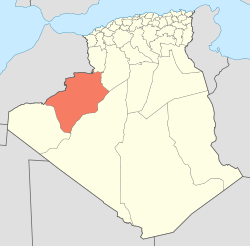 | |
| Abadla District | ||
| Béni Abbès District | ||
| Béni Ounif District | ||
| El Ouata District | ||
| Igli District | ||
| Kénadsa District | ||
| Kerzaz District | ||
| Lahmar District | ||
| Ouled Khodeïr District | ||
| Tabelbala District | ||
| Taghit District | ||