Kerch
| Kerch Керчь Керч | |||
|---|---|---|---|
| city | |||
|
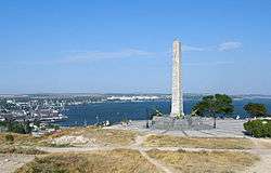
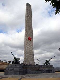
Kerch. Obelisk of Glory on Mount Mithridates | |||
| |||
.svg.png) Kerch Location of Kerch | |||
| Coordinates: 45°21′43″N 36°28′16″E / 45.36194°N 36.47111°ECoordinates: 45°21′43″N 36°28′16″E / 45.36194°N 36.47111°E | |||
| Country |
Disputed: | ||
| Republic | Crimea | ||
| Region | Kerch City Municipality | ||
| Area | |||
| • Total | 108 km2 (42 sq mi) | ||
| Elevation | 10 m (30 ft) | ||
| Population (2014) | |||
| • Total | 147,033 | ||
| • Density | 1,464.49/km2 (3,793.0/sq mi) | ||
| Time zone | MSK (UTC+3) | ||
| Postal code | 98300 — 98399 | ||
| Area code(s) | +7-36561 | ||
| Former name(s) | Panticapaeum, Bosporus, Vosporo, Korchev, Cerchio | ||
| Sister cities | Mogilev, Smolensk, Çanakkale, Oryol, Odintsovo, Sochi | ||
| Climate | Cfa | ||
| Website | gorsovetkerch.ru | ||

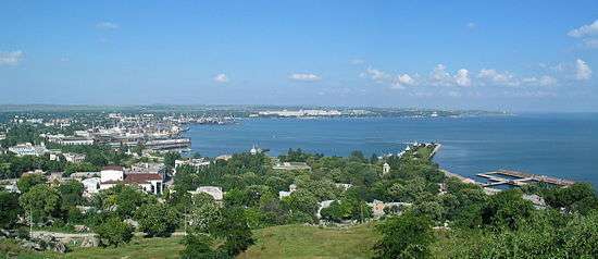
Kerch (Russian: Керчь, Ukrainian: Керч, Old East Slavic: Кърчевъ, Crimean Tatar: Keriç, Turkish: Kerç, Ancient Greek: Παντικάπαιον Pantikapaion) is a city of regional significance on the Kerch Peninsula in the east of the Crimea. Population: 147,033 (2014 Census).[1]
Founded 2,600 years ago as an ancient Greek colony, Kerch is considered to be one of the most ancient cities in Crimea. The city experienced rapid growth starting in the 1920s and was the site of a major battle during World War II.
Today, it is one of the largest cities in Crimea and is among the republic's most important industrial, transport and tourist centres.
History
Ancient times
Archeological digs at Mayak village near the city ascertained that the area had already been inhabited in 17th–15th centuries BC.
Kerch as a city starts its history in 7th century BC, when Greek colonists from Miletus founded a city-state named Panticapaeum[2] on Mount Mithridat near the mouth of the Melek-Chesme river. Panticapaeum subdued nearby cities and by 480 BC became a capital of the Kingdom of Bosporus. Later, during the rule of Mithradates VI Eupator, Panticapaeum for a short period of time became the capital of the much more powerful and extensive Kingdom of Pontus.
The city was located at the intersection of trade routes between the steppe and Europe. This caused it to grow rapidly. The city's main exports were grain and salted fish, wine-making was also common. Panticapaeum minted its own coins. According to extant documents the Melek-Chesme river (small and shallow nowadays) was navigable in Bosporan times, and sea galleys were able to enter the river. A large portion of the city's population was ethnically Scythian, later Sarmatian, as the large royal barrow (Kurgan) at Kul-Oba testifies.
In the 1st century AD Panticapaeum and the Kingdom of Bosporus suffered from Ostrogoth raids, then the city was devastated by the Huns in AD 375.
Middle Ages
From the 6th century the city was under the control of the Byzantine Empire. By order of Emperor Justinian I, a citadel named Bospor was built there. Bospor was the centre of a bishopric, the diocese of Bosporus and developed under the influence of Greek Christianity. In 576, it withstood a siege by the Göktürks under Bokhan, aided by Anagai, the last khan (ruler) of the Uturgurs (tribe of Huns).

In the 7th century, the Turkic Khazars took control of Bospor, and the city was named Karcha from Turkic "karşı" meaning 'opposite, facing.' The main local government official during Khazar times was the tudun. Christianity was a major religion in Kerch during the period of Khazar rule. Kerch's Church of St. John the Baptist was founded in 717, thus, it is the oldest church in Ukraine. The "Church of the Apostles" existed during the late 8th and early 9th centuries, according to the "Life of the Apostle Andrew" by Epiphanius of Salamis.
Following the fall of Khazaria to Kievan Rus' in the late 10th century, Kerch became the centre of a Khazar successor-state. Its ruler, Georgius Tzul, was deposed by a Byzantine-Rus expedition in 1016.
From the 10th century, the city was a Slavic settlement named Korchev, which belonged to the Tmutarakan principality. Kerch was a center of trade between Russia', Crimea, Caucasus and the Orient.
In the 13th century, the Crimea including Korchev was invaded by Mongols. After Mongols, the city became the Genoese colony of Cerco (Cherkio) in 1318 and served as a sea harbour, where townspeople worked at salt-works and fishery.
In 1475, city was passed to the Ottoman Empire. During the Turkish rule Kerch fell into decay and served as a slave-market.[3] It repeatedly suffered from raids of Zaporizhian Cossacks.
18th - 20th centuries
In response to strengthening of Russian military forces in Azov area, the Turks built a fortress, named Yenikale, near Kerch on the shore of Kerch Strait. The fortress was completed by 1706. In 1771 the Imperial Russian Army invaded Crimea and approached Yenikale. The Turks decided to abandon the fortress, though reinforcements from the Ottoman Empire had arrived a few days earlier. By the Peace Treaty of Kuchuk-Kainarji in 1774, Kerch and Yenikale were ceded to Russia. As a result, the Turkish heritage has been almost completely wiped out.
In 1790 Russian naval forces under the command of admiral Fyodor Ushakov defeated the Turkish fleet at the Battle of Kerch Strait.[4]
Because of its location, from 1821 Kerch developed into an important trade and fishing port. The state museum of ancient times and a number of educational institutions were opened in the city. The ironwork factory was built in 1846 based on a huge iron ore deposit found on Kerch Peninsula.
During the Crimean War the city was devastated by British forces in 1855.
In the late 19th century, mechanical and cement factories were built, and tinned food and tobacco factories were established. By 1900, Kerch was connected to a railroad system, and the fairway of Kerch Strait was deepened and widened. At this time, the population had reached 33,000.
After suffering a decline during the First World War and the Russian Civil War, the city resumed its growth in the late 1920s, with the expansion of various industries, iron ore and metallurgy in particular, and by 1939 its population had reached 104,500.
Kerch in World War II
On the Eastern Front of World War II from 1941 to 1945, Kerch was the site of heavy fighting between Soviet Army and Axis forces. After fierce fighting, the city was taken by the Germans in November 1941. On 31 December 1941 the 302nd Mountain Rifle Division recaptured the city following a naval landing operation at Kamysh Burun, to the south of the city, five days earlier.[5] In 1942 the Germans occupied the city again. The Red Army lost over 160,000 men, either killed or taken POW at the Battle of the Kerch Peninsula. On 31 October 1943 another Soviet naval landing operation was launched. Kerch returned to Soviet control on 11 April 1944.
The German invaders killed about 15,000 citizens and deported another 14,000 during their occupation. Evidence of German atrocities in Kerch was presented in the Nuremberg trials. After the war, the city was awarded the title Hero City.
The Adzhimushkay catacombs (mines) in the city's suburbs were the site of guerrilla warfare against the occupation. Thousands of soldiers and refugees found shelter inside, and were involved in counterattacks. Many of them died underground, including those who died of numerous alleged poison gas attacks. Later, a memorial was established on the site.
Modern Kerch
Administrative divisions
The city municipality stretches over a substantial area and includes several separate neighborhoods that are part of the Kerch city: Eltigen (Heroyevskoe), Kamysh-Burun (Arshyntsevo), Port Krym, Adzhimushkai, and Tuzla Island.
Industry
Today Kerch is considered as a city of metallurgists, shipbuilders and fishermen. The largest enterprises in the city are:
- Kerch Metallurgical Works Factory launched in 1900
- Kamysh-Burun Iron Ore Plant
- "Zaliv" ("Gulf") shipbuilding factory that produces and repairs tankers and cargo ships.
Construction-materials, food processing, and light industries play a significant role in the city's economy. Kerch is also a fishing fleet base and an important processing centre for numerous fish products.
Transport
Kerch has a harbour on the Kerch Strait, which makes it a key to the Sea of Azov, several railroad terminals and a small airport. The Kerch Strait ferry line across the Kerch Strait was established in 1953, connecting Crimea and the Krasnodar Krai (Port Krym - Port Kavkaz line); (as of November 2009) there are also plans for a Kerch-Poti ferry route.[6]
There are several ports in Kerch, including Kerch Maritime Trading Port, Kerch Maritime Fishing Port, Port Krym (ferry crossing), Kamysh-Burun Port.
The railroad terminals include: Kerch, Kerch I, Kerch Factory, Arshyntsevo, and Krym.
Bus network connects Kerch to other cities in Crimea and Krasnodar Krai.
Education
Kerch hosts (2004):
- 28 schools,
- 9 institutes and branches of Ukrainian and Russian universities,
- shipbuilding and polytechnical colleges,
- medical school,
- 6 PTU schools,
- a number of pre-school child institutions
Archaeology
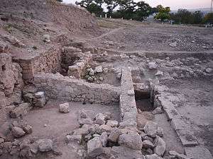
Archaeological digs in Kerch were launched under Russian auspices in the middle of the 19th century. Since then the site of ancient Panticapaeum city on Mount Mithridat has been systematically excavated. Located nearby are several ancient burial mounds (kurgans) and excavated cities. Kerch takes part in UNESCO's "Silk Road" programme.
Treasures and historical findings of Kerch adorn the collections of major museums around the world. Such as: the Hermitage, the Louvre, the British Museum, the Berlin Museum, the Moscow State Museum of fine arts and many others.
Currently, excavations at ancient fortresses of Kerch are led by scientists from Russia, Ukraine, and Poland.
Tourism
Because of its location on shores of Azov and Black seas, Kerch became a popular summer resort among people of former USSR. Also, several mud-cure sources are located near the city. Despite the seaside location, the tourist appeal of Kerch today is limited because of the industrial character of the city and associated pollution. Despite the lack of beaches in the town's area, there are a lot of them at a distance of 20 minutes' travel by bus, train or taxi.
Kerch has a number of impressive architectural and historical monuments. Ancient historical heritage of the city makes it attractive for scientific tourism. The most notable of Kerch's sights are:
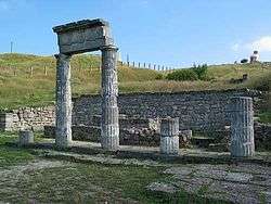
- Site of ancient settlement Pantikapaeum (5th century BC–3rd century AD).
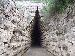
- Tsarskiy Kurghan (4th century BC) - burial mound for one of Bosporian kings
- Church of St. John the Baptist (AD 717)
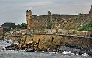
- Fortress of Yenikale (18th century)
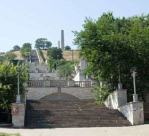
- The Great Mithridates Staircase leading on top of the Mount Mithridat, contains 428 footsteps, built in 1833–1840 under the guidance of Italian architect A. Digbi
- Obelisk of Glory on the Mount Mithridat, built after World War II
- Lapidarium
- Memorial of heroic guerilla warfare in Adzhimushkay mines
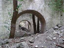
- Kerch Fortress; restricted area in Soviet times but free to enter in present days. The fortress was built by the Russian military architect Totleben in the middle of 19th century.
- Sites of ancient settlements Mirmecium, Tiritaka and Nimphei. There are also some settlements which have gone underwater due to earthquakes.
- So called Demetra's Crypt, a crypt with numerous frescos dated 1st century BC.
Festivals and celebrations
- Liberation Day (11 April)
- Day of Fishermen (the second Sunday of July)
- Day of the City (the second Saturday of September)
Honours
A minor planet 2216 Kerch discovered in 1971 by Soviet astronomer Tamara Mikhailovna Smirnova is named after the city.[7]
Twin towns - Sister cities
| City | Country | Year |
|---|---|---|
| Mogilev | |
1998 |
| Smolensk | |
1998 |
| Çanakkale | |
1999 |
| Oryol | |
2004 |
| Odintsovo | |
2004 |
| Sochi | |
2005 |
| Tula, Russia | |
2014 |
Climate
Kerch has a humid subtropical climate (Köppen climate classification Cfa)[8] with cool to cold winters and warm to hot summers.
| Climate data for Kerch | |||||||||||||
|---|---|---|---|---|---|---|---|---|---|---|---|---|---|
| Month | Jan | Feb | Mar | Apr | May | Jun | Jul | Aug | Sep | Oct | Nov | Dec | Year |
| Record high °C (°F) | 15.6 (60.1) |
17.5 (63.5) |
23.4 (74.1) |
27.6 (81.7) |
30.6 (87.1) |
34.9 (94.8) |
37.4 (99.3) |
37.2 (99) |
33.2 (91.8) |
30.9 (87.6) |
22.7 (72.9) |
19.4 (66.9) |
37.4 (99.3) |
| Average high °C (°F) | 3.5 (38.3) |
3.8 (38.8) |
7.8 (46) |
14.3 (57.7) |
20.2 (68.4) |
25.0 (77) |
28.1 (82.6) |
27.8 (82) |
22.6 (72.7) |
16.3 (61.3) |
9.8 (49.6) |
5.3 (41.5) |
15.4 (59.7) |
| Daily mean °C (°F) | 0.6 (33.1) |
0.4 (32.7) |
3.8 (38.8) |
9.8 (49.6) |
15.4 (59.7) |
20.3 (68.5) |
23.4 (74.1) |
23.1 (73.6) |
17.9 (64.2) |
12.2 (54) |
6.2 (43.2) |
2.4 (36.3) |
11.3 (52.3) |
| Average low °C (°F) | −2.1 (28.2) |
−2.6 (27.3) |
0.5 (32.9) |
5.8 (42.4) |
10.8 (51.4) |
15.5 (59.9) |
18.6 (65.5) |
18.4 (65.1) |
13.3 (55.9) |
8.3 (46.9) |
3.2 (37.8) |
−0.3 (31.5) |
7.5 (45.5) |
| Record low °C (°F) | −23.7 (−10.7) |
−23.1 (−9.6) |
−15.6 (3.9) |
−6.5 (20.3) |
−0.6 (30.9) |
3.4 (38.1) |
9.9 (49.8) |
7.5 (45.5) |
1.0 (33.8) |
−5.4 (22.3) |
−11.8 (10.8) |
−17.6 (0.3) |
−23.7 (−10.7) |
| Average precipitation mm (inches) | 33 (1.3) |
32 (1.26) |
34 (1.34) |
32 (1.26) |
30 (1.18) |
55 (2.17) |
36 (1.42) |
49 (1.93) |
38 (1.5) |
29 (1.14) |
45 (1.77) |
44 (1.73) |
457 (17.99) |
| Average rainy days | 10 | 9 | 11 | 11 | 9 | 10 | 6 | 6 | 8 | 9 | 11 | 11 | 111 |
| Average snowy days | 8 | 8 | 5 | 0.2 | 0 | 0 | 0 | 0 | 0 | 0.1 | 2 | 7 | 30 |
| Average relative humidity (%) | 85 | 84 | 80 | 76 | 73 | 71 | 67 | 67 | 71 | 77 | 83 | 85 | 77 |
| Mean monthly sunshine hours | 70 | 88 | 145 | 190 | 274 | 306 | 334 | 308 | 252 | 184 | 91 | 56 | 2,298 |
| Source #1: Pogoda.ru.net[9] | |||||||||||||
| Source #2: NOAA (sun, 1961–1990)[10] | |||||||||||||
Recent events
 |
.jpg) |
 | ||
| Fortress Kerch | Interior of St John the Baptist Church. | Royal barrow (Royal Kurgan) entrance. |
Autumn storm of 2007
On 11 November 2007 there was a great storm that passed through the city, causing much damage and an ecological disaster as a few ships, including an oil tanker, were shipwrecked and blocked the Kerch Strait.
Kerch Strait Bridge
On 25 April 2010, Ukrainian President Viktor Yanukovych and Russian President Dmitry Medvedev signed an agreement to build a bridge across the Kerch Strait. In January 2015, the multibillion-dollar contract for the construction of the bridge was awarded to Arkady Rotenberg's SGM Group. In May 2015, construction of the bridge commenced; it is projected to be fully completed and operational by 2019.
See also
- Panticapaeum
- Kingdom of Bosporus
- Yenikale
- Mount Mithridat
- Kerch Strait
- Tuzla Island
- Kerch (fortress)
References
- ↑ Russian Federal State Statistics Service (2014). "Таблица 1.3. Численность населения Крымского федерального округа, городских округов, муниципальных районов, городских и сельских поселений" [Table 1.3. Population of Crimean Federal District, Its Urban Okrugs, Municipal Districts, Urban and Rural Settlements]. Федеральное статистическое наблюдение «Перепись населения в Крымском федеральном округе». ("Population Census in Crimean Federal District" Federal Statistical Examination) (in Russian). Federal State Statistics Service. Retrieved January 4, 2016.
- ↑ See Talk:Kerch#Meaning of Greek name? for discussion about the Greek name Panticapaeum.
- ↑ Halil Inalcik. "Servile Labor in the Ottoman Empire"
- ↑ Black Sea Fleet (BSF) Morskoyo Flota ( Naval Force)
- ↑ Robert Forczyk, Where The Iron Crosses Grow, Osprey Publishing, Oxford, UK, 2014, pp 103, 110
- ↑ Yushchenko says Ukraine to try quickly implement Kerch-Poti ferry route project, Kyiv Post (19 November 2009)
- ↑ Schmadel, Lutz D. (2003). Dictionary of Minor Planet Names (5th ed.). New York: Springer Verlag. p. 180. ISBN 3-540-00238-3.
- ↑ Kottek, M.; J. Grieser; C. Beck; B. Rudolf; F. Rubel (2006). "World Map of the Köppen-Geiger climate classification updated" (PDF). Meteorol. Z. 15 (3): 259–263. doi:10.1127/0941-2948/2006/0130. Retrieved 11 December 2012.
- ↑ "КЛИМАТ КЕРЧИ" (in Russian). Погода и климат. Retrieved 29 November 2015.
- ↑ "Kerc' (Kerch) Climate Normals 1961–1990". National Oceanic and Atmospheric Administration. Retrieved 29 November 2015.
External links
| Wikimedia Commons has media related to Kerch. |
| Wikivoyage has a travel guide for Kerch. |
- Моя Керчь multi portal My Kerch: news, photo gallery, announcements, etc.
- Керчь - это город interactive map of Kerch
- Керчь - это мой город unofficial website of Kerch: information, news, photos, forum etc. (Russian)
- Webcams
- Photos of Kerch from Panoramio
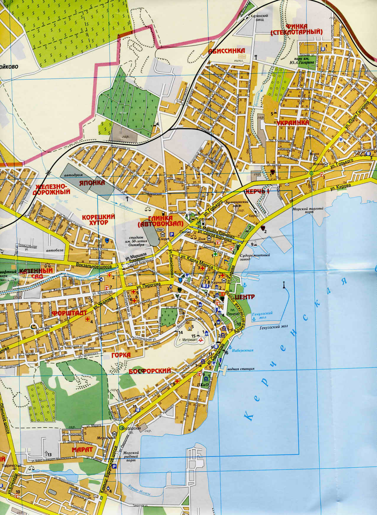
- Map of Kerch's Center (by "Kartografia", 2004)
- Infos and photos of Kerch in travelguide around Ukraine
- The murder of the Jews of Kerch during World War II, at Yad Vashem website.
| Raions | |||||||
|---|---|---|---|---|---|---|---|
| Municipalities | |||||||
| Cities | |||||||
| |||||||
Hero Cities of the Soviet Union | ||
|---|---|---|