Khodovarikha
| Khodovarikha | |
|---|---|
| Ходовариха | |
|
Location of Khodovarikha in the Barents Sea shore | |
 | |
| Location |
Nenets Autonomous Okrug, Arkhangelsk Oblast, Russian Federation |
| Coordinates | 68°56′28″N 53°46′08″E / 68.941°N 53.769°ECoordinates: 68°56′28″N 53°46′08″E / 68.941°N 53.769°E |
| Offshore water bodies | Pechora Sea |
| Area | Arctic |
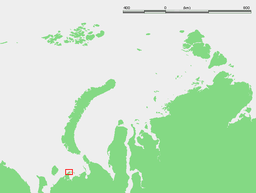
Khodovarikha (Russian: Ходовариха) is a point in the coast of the Pechora Sea located on a landspit projecting eastwards over the bay. Latitude: 68° 57' Longitude: 53° 45'[1][2]
Khodovarikha belongs to the Nenets Autonomous Okrug administrative region, which is an autonomous okrug of Arkhangelsk Oblast.
History
There is a lighthouse at Khodovarikha that used to be an important beacon for the Russian convoy route coming from the Yugorsky Strait in World War II. It was shelled in 1942 by the Kriegsmarine during Operation Wunderland. The lighthouse ceased operation in 1996.
There was a small populated place close by that has been abandoned. However, there is still a functioning weather station in Khodovarikha.[3]
Khodovarikha was the subject of a 2015 RT documentary Arctic Limbo, chronicling the isolation of the weather station staff.
References
- ↑ Location
- ↑ "Khodovarikha". Mapcarta. Retrieved 23 September 2016.
- ↑ Simon Bowcock (October 26, 2015). "Slava of the Arctic: the world's most extreme weatherman". The Guardian. Retrieved October 26, 2015.