Kilmar Tor
| Kilmar Tor | |
|---|---|
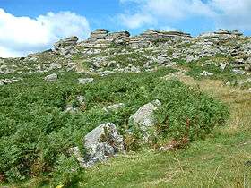 Kilmar Tor from the SE. Trig point just visible on the right. | |
| Highest point | |
| Elevation | 396 m (1,299 ft) [1] |
| Prominence | 118 m (387 ft) [1] |
| Listing | HuMP |
| Geography | |
| Location | Bodmin Moor, Cornwall |
| OS grid | SX252748 |
| Topo map | OS Landranger 201, Explorer 109 |
| Geology | |
| Mountain type | granite tor |
Kilmar Tor (Cornish: Kil Margh) is an elongated hill, 396 metres (1,299 ft) high and running from SW to NE, on Bodmin Moor in the Duchy of Cornwall, England.[2] Its prominence of 118 metres qualifies it as a HuMP.
Kilmar Tor is located on the eastern side of Bodmin Moor, about 2½ kilometres WSW of the hamlet of North Hill and 3½ kilometres north of Cornwall's highest village, Minions. It is surmounted by granite tors. There is trig point at the summit as well as a cairn and cist. The course of a dismantled railway runs around the hill to the south, evidence of the mining that used to be carried out in the area.[2]
On Kilmar Tor's northern flank is Twelve Men's Moor with Trewortha Tor and Hawk's Tor beyond the saddle. To the southeast is Bearah Tor and, to the south, Langstone Downs. Withy Brook runs roughly north to south past the western end of the hill and, to the east, open moorland descends to the valley of the River Lynher.[2]
References
- 1 2 Jackson, Mark. "More Relative Hills of Britain" (PDF). Relative Hills of Britain. p. 166. Retrieved 31 March 2013.
- 1 2 3 Ordnance Survey 1:25,000 Explorer map series, No. 109
Coordinates: 50°32′N 4°28′W / 50.533°N 4.467°W