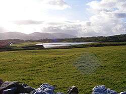
Kiltooris Lough
| Kiltooris Lough | |
|---|---|
 | |
 Location in Ireland | |
| Location | County Donegal |
| Coordinates | 54°49′9″N 8°30′2″W / 54.81917°N 8.50056°WCoordinates: 54°49′9″N 8°30′2″W / 54.81917°N 8.50056°W |
| Catchment area | 5.55 km2 (2.1 sq mi) |
| Basin countries | Ireland |
| Max. length | 1.4 km (1 mi) |
| Max. width | 0.5 km (0.3 mi) |
| Surface area | 0.43 km2 (0.17 sq mi) |
| Max. depth | 13.5 m (44 ft) |
| Surface elevation | 7 m (23 ft) |
| Islands | Inishywadigan, Rossbeg Island, Thorn Island, O'Boyle's Island |
| References | [1][2][3] |
Kiltooris Lough is a freshwater lake in the northwest of Ireland. It is located in southwest County Donegal near Dawros Bay.
Geography and hydrology
Kiltooris Lough is about 8 kilometres (5 mi) northwest of Ardara.[3] It measures about 1.5 km (1 mi) long north–south and 0.5 km (0.3 mi) wide.[2] Kiltooris Lough is oligotrophic.[4]
Natural history
Fish species in Kiltooris Lough include salmon, three-spined stickleback and the critically endangered European eel.[3] Kiltooris Lough is part of the West of Ardara/Maas Road Special Area of Conservation.[4]
See also
References
- ↑ "A Reference Based Typology and Ecological Assessment System for Irish Lakes" (PDF). Environmental Protection Agency (Ireland). 2006. p. 18. Retrieved 7 Feb 2016.
- 1 2 Google (7 Feb 2016). "Kiltooris Lake" (Map). Google Maps. Google. Retrieved 7 Feb 2016.
- 1 2 3 "Water Framework Directive Fish Stock Survey of Kiltooris Lough" (PDF). Inland Fisheries Ireland. Aug 2014. Retrieved 7 Feb 2016.
- 1 2 "West of Ardara/Maas Road SAC" (PDF). National Parks and Wildlife Service (Ireland). Retrieved 7 Feb 2016.
This article is issued from Wikipedia - version of the 2/8/2016. The text is available under the Creative Commons Attribution/Share Alike but additional terms may apply for the media files.