King (crater)
|
| |
| Coordinates | 5°00′N 120°30′E / 5.0°N 120.5°ECoordinates: 5°00′N 120°30′E / 5.0°N 120.5°E |
|---|---|
| Diameter | 76 km |
| Depth | Unknown |
| Colongitude | 241° at sunrise |
| Eponym |
Arthur S. King Edward S. King |
King is a prominent lunar impact crater that is located on the far side of the Moon, and can not be viewed directly from Earth. It forms a pair with Ibn Firnas, which is only slightly larger and is attached to the northeast rim of King. To the northwest is the crater Lobachevskiy, and Guyot is located an equal distance to the north-northwest.
The outer rim of King is roughly circular but with a slightly irregular appearance, particularly at the northern end. The crater displays little appearance of wear. The inner walls are terraced, particularly along the eastern side. Within the walls is a somewhat uneven interior floor. The interior is irregular and ridged, particularly in the eastern half. The elongated, Y-shaped central rise is part of a ridge that runs to the southern rim.
A tiny crater near the east-southeastern inner wall has been officially given the Indian feminine name Sita by the IAU. It is located at selenographic coordinates 4.6° N, 120.8° E, and has a diameter of 2 kilometres.
Due to its prominent rays, King is mapped as part of the Copernican System.[1]
Prior to naming in 1970 by the IAU,[2] this crater was known as Crater 211.[3]
Satellite craters
By convention these features are identified on lunar maps by placing the letter on the side of the crater midpoint that is closest to King.
| King | Latitude | Longitude | Diameter |
|---|---|---|---|
| J | 3.2° N | 121.8° E | 14 km |
| Y | 6.5° N | 119.8° E | 48 km |
The name "Al-Tusi" had been suggested for King Y, but this was not approved by the IAU.
Mountain Peaks
Several mountain peaks (Montes) within King crater have been named. The names were approved by the IAU in 1976.
| Mons | Latitude | Longitude | Approximate Altitude[4] |
|---|---|---|---|
| Andre | 5.18° N | 120.56° E | 7000 m |
| Ardeshir | 5.03° N | 121.04° E | 5900 m |
| Dieter | 5.00° N | 120.30° E | 8000 m |
| Dilip | 5.58° N | 120.87° E | 5500 m |
| Ganau | 4.79° N | 120.59° E | 7900 m |
Views
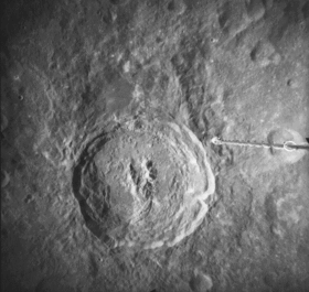
 Oblique view from Apollo 14
 Oblique view from Apollo 12
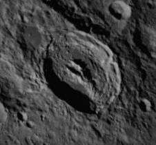
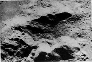 Closeup of the central peaks from Apollo 16
 Oblique view of the "pool" (King Y) north of King from Apollo 16
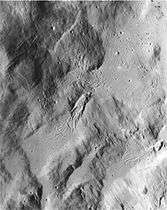 Closeup of the impact melt northeast of the crater, showing flow structures, from Apollo 16
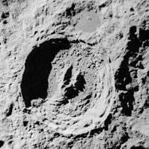 View of King during Apollo 16's trans-earth injection
References
- ↑ The geologic history of the Moon, 1987, Wilhelms, Don E.; with sections by McCauley, John F.; Trask, Newell J. USGS Professional Paper: 1348. Plate 11: Copernican System (online)
- ↑ King, Gazetteer of Planetary Nomenclature, International Astronomical Union (IAU) Working Group for Planetary System Nomenclature (WGPSN)
- ↑ Lunar Farside Chart (LFC-1A)
- ↑ LTO65C1 King Lunar Topographic Orthophotomap, 1974
- Wood, Chuck (2006-06-26). "King of the Farside". Lunar Photo of the Day. Retrieved 2006-07-12.
- Andersson, L. E.; Whitaker, E. A. (1982). NASA Catalogue of Lunar Nomenclature. NASA RP-1097.
- Blue, Jennifer (July 25, 2007). "Gazetteer of Planetary Nomenclature". USGS. Retrieved 2007-08-05.
- Bussey, B.; Spudis, P. (2004). The Clementine Atlas of the Moon. New York: Cambridge University Press. ISBN 978-0-521-81528-4.
- Cocks, Elijah E.; Cocks, Josiah C. (1995). Who's Who on the Moon: A Biographical Dictionary of Lunar Nomenclature. Tudor Publishers. ISBN 978-0-936389-27-1.
- McDowell, Jonathan (July 15, 2007). "Lunar Nomenclature". Jonathan's Space Report. Retrieved 2007-10-24.
- Menzel, D. H.; Minnaert, M.; Levin, B.; Dollfus, A.; Bell, B. (1971). "Report on Lunar Nomenclature by the Working Group of Commission 17 of the IAU". Space Science Reviews. 12 (2): 136–186. Bibcode:1971SSRv...12..136M. doi:10.1007/BF00171763.
- Moore, Patrick (2001). On the Moon. Sterling Publishing Co. ISBN 978-0-304-35469-6.
- Price, Fred W. (1988). The Moon Observer's Handbook. Cambridge University Press. ISBN 978-0-521-33500-3.
- Rükl, Antonín (1990). Atlas of the Moon. Kalmbach Books. ISBN 978-0-913135-17-4.
- Webb, Rev. T. W. (1962). Celestial Objects for Common Telescopes (6th revised ed.). Dover. ISBN 978-0-486-20917-3.
- Whitaker, Ewen A. (1999). Mapping and Naming the Moon. Cambridge University Press. ISBN 978-0-521-62248-6.
- Wlasuk, Peter T. (2000). Observing the Moon. Springer. ISBN 978-1-85233-193-1.
External links
- From LROC:
- King Crater's Unusual Melt Pond
- King crater ejecta deposits
- Anomalous mounds on the King crater floor
- Fault scarp with impact melt in King crater
- Making a Splash at King Crater
- King Crater Flyover by Lunar and Planetary Institute
- Figures 149 to 151 and Figures 152 to 160 in Chapter 5 of APOLLO OVER THE MOON: A View From Orbit (NASA SP-362, 1978) are various views of King Crater