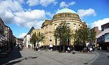
King Street, Kilmarnock
 The junction of King Street and Portland Street | |
| Length | 0.2 mi[1] (0.3 km) |
|---|---|
| Location | Kilmarnock |
| Postal code | KA1 |
| north end |
Portland Street 55°36′37″N 4°29′48″W / 55.6102°N 4.4966°W |
| south end |
55°36′27″N 4°29′50″W / 55.6075°N 4.4971°W |
| Construction | |
| Completion | 1804 |
King Street was once the principal business street in Kilmarnock, East Ayrshire, Scotland.[2] King Street runs from the "Cross" over the Kilmarnock Water and on to the junction with Titchfield Street.
History
King Street was opened up in 1804. Many historic buildings in King Street (including the Town House and the King Street Church) were demolished during the redevelopments in the 70's and 80's. These buildings were replaced by modern architecture which stand in their place today. The demolition of the eastern side of King Street was criticised in a report commissioned by East Ayrshire Council for the effect it had on the historical and architectural heritage of the area.[3]
References
- ↑ "Walking directions to King St". Google Maps. Google. Retrieved 28 April 2014.
- ↑ Ramble Round Kilmarnock - Chapter 1
- ↑ Austin-Smith:Lord LLP (24 October 2007). "Conservation Area Appraisal and Management Plan" (PDF). East Ayrshire Council. p. 49. Retrieved 28 April 2014.
This article is issued from Wikipedia - version of the 10/3/2014. The text is available under the Creative Commons Attribution/Share Alike but additional terms may apply for the media files.