Kinjo Dam
| Kinjo Dam | |
|---|---|
 | |
| Country | Japan |
| Location | Naha, Okinawa |
| Coordinates | 26°12′44″N 127°43′03″E / 26.21222°N 127.71750°ECoordinates: 26°12′44″N 127°43′03″E / 26.21222°N 127.71750°E |
| Status | Operational |
| Construction began | 1989 |
| Opening date | 2000 |
| Dam and spillways | |
| Type of dam | Concrete gravity |
| Height | 19 m (62 ft) |
| Length | 120 m (394 ft) |
| Elevation at crest | 52 m (171 ft) |
| Dam volume | 14,250 m3 (18,638 cu yd) |
| Spillways | 5-openings |
| Spillway type | Service, uncontrolled overflow |
| Reservoir | |
| Total capacity | 510,000 m3 (413 acre·ft) |
| Active capacity | 470,000 m3 (381 acre·ft) |
| Catchment area | 1.7 km2 (1 sq mi) |
| Surface area | 400 m2 (4,306 sq ft)[1] |
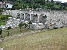
The Kinjo Dam (金城ダム Kinjō Damu) is a concrete gravity dam on the Li River in Naha, Okinawa Prefecture, Japan. It is designated as a cultural property and is located 500 m (1,640 ft) south of Shuri Castle.[2] Construction on the dam began in 1989 and it was completed in 2000.[3] Its main purpose is flood control and on average, it can control an intake of 40 m3/s (1,413 cu ft/s); releasing 23 m3/s (812 cu ft/s). The 19 m (62 ft) tall and 120 m (394 ft) long dam was constructed on fragile rock and is set on a deep concrete staircase foundation.[1]
References
- 1 2 "Dam Design" (in Japanese). Okinawa Dam. Retrieved 26 July 2011.
- ↑ "Location and Cultural Heritage" (in Japanese). Okinawa Dam. Retrieved 26 July 2011.
- ↑ "Kinjo Dam Overview" (in Japanese). Okinawa Dam. Retrieved 26 July 2011.
| Wikimedia Commons has media related to Kinjo Dam. |
This article is issued from Wikipedia - version of the 10/8/2015. The text is available under the Creative Commons Attribution/Share Alike but additional terms may apply for the media files.