Klang River
| Klang River | |
|---|---|
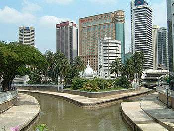 The Gombak River (left) merges with the Klang River (right) at Kuala Lumpur. | |
| Native name | Sungai Klang (Malay) |
| Country | Selangor and Kuala Lumpur, Malaysia |
| Basin | |
| Main source |
Kuala Seleh 100 m (330 ft) |
| River mouth | Strait of Malacca |
| Physical characteristics | |
| Length | 120 km (75 mi) |
| Discharge |
|
Klang River (Malay: Sungai Klang) is a river which flows through Kuala Lumpur and Selangor in Malaysia and eventually flows into the Straits of Malacca. It is approximately 120 km (75 mi) in length and drains a basin of about 1,288 km2 (497 sq mi). Klang River has 11 major tributaries.
Because the river flows through Klang Valley, which is a heavily populated area of more than four million people, it is considerably polluted. Heavy development has narrowed certain stretches of the river to the point that it resembles a large storm drain in some places. This contributes to flash floods in Kuala Lumpur, especially after heavy rain.
Course
Klang River originates in the highlands, 25 kilometres (16 mi) northeast of Kuala Lumpur. It is joined by 11 major tributaries. These include Gombak River, Batu River, Kerayong River, Damansara River, Keruh River, Kuyoh River, Penchala River and Ampang River. It flows into the Straits of Malacca to the west.
Places named after the river
The river's confluence with the Gombak River gave rise to the name of Kuala Lumpur, Malaysia's capital city. Kuala Lumpur means "muddy estuary". It is also thought that Klang town is named after the river.
Cities and towns on its banks
Kuala Lumpur is situated at the point where Gombak River flows into Klang River. It then flows south of the city of Petaling Jaya. Further downstream, the river flows through Selangor's state capital, Shah Alam. Klang town is situated on the lower stretches of the river.
Malaysia's biggest sea port, Port Klang, is also situated at the estuary of Klang river.
Dams
There are two major dams upstream of the river; Batu Dam and Klang Gates Dam, which provide water supply to the people of Klang Valley and mitigate floods.
Privatisation
The maintenance of Klang River was privatised.[1] Under 30-year concessions, three firms were to manage a river each and ensure cleanliness.[2][3]
Flood mitigation
Kuala Lumpur Flood Mitigation
Kuala Lumpur Flood Mitigation[4] is a project to mitigate flash floods from Gombak River into a few stormwater ponds located in Batu, Jinjang and Kepong.
SMART Tunnel
The SMART Tunnel (Stormwater Management and Road Tunnel) functions as an innovative solution to mitigating both traffic congestion and flooding. It is a submerged tunnel which can carry both vehicular traffic as well as storm runoff on a lower level. When regular drainage infrastructure is overwhelmed, vehicles are evacuated from the tunnel and the entire tube is used as a gigantic storm drain to prevent Kuala Lumpur from flooding. It diverts water flow from the Kampung Berembang Lake, near Klang River, to Taman Desa Lake, which is near Kerayong River (one of Klang River's tributaries). Water flow can also go the opposite direction, from Kerayong River to Klang River. SMART opened in May 2007.
Clean Up Efforts
In 2010 Selangor has a stimulus bill that included money to help rehabilitate it. The river's condition has been described as "between critical and bad" by Gareth Jones of Wessex Water, a UK-based company that is participating in the project. Kamal Zaharin, the project mastermind, states that the plans include river cleaning, new source of drinking water, environmental protection, flood mitigation, commercial, tourism and land development activities. Gareth Jones also stated that they plan on tapping groundwater in order to have a source of water that is not the sea.[5]
The project has been estimated take 15 years and attract 15 billion dollars worth of investments.[5]
See also
References
- ↑ "Governance and Freshwater in the Greater Kuala Lumpur Area/Klang Valley:Success or Failure?" (PDF). Akademika. 81 (3): 95–102. 2011.
- ↑ "MALAYSIA: Fighting the Flow of River Privatisation". 2006-02-24.
- ↑ Muthiah, W. (2006-07-02). "Three rivers in Selangor to go private soon". The Star. p. 3.
- ↑ http://www.nre.gov.my/opencms/opencms/NRE/EN/Services/Water/flood.html
- 1 2 NG, Angie. "Selangor to clean up Klang River". The Star. Retrieved 25 March 2011.
Coordinates: 3°00′N 101°23′E / 3.000°N 101.383°E
| Wikimedia Commons has media related to Klang River. |