Knik Arm


Knik Arm is a waterway into the northwestern part of the Gulf of Alaska. It is one of two narrow branches of Cook Inlet, the other being Turnagain Arm. Knik Glacier empties into the Knik Arm. The Port of Anchorage is located on the Arm.
Etymology
Knik is the Eskimo–Aleut language word for "fire". It has been written Kinik, Kneep, Kneik, Kook, Knuyk, and Kweek.[1]
Geography
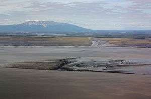
Knik Arm begins at the Inlet's northern edge, near Anchorage, before heading north and east. It is about 15 miles (24 km) long, and at its upper end, receives the waters of the Matanuska River. West of Knik Arm is the delta of the Susitna River, the largest stream emptying into the inlet.[2] At the head of Knik Arm, at the mouth of Knik River, was the village (ghost town) of Knik.[3] Knik Arm receives two or three small streams from the east, of which Yukla Creek, 35 miles (56 km) long, is one of the largest. Its western tributaries are not notable, the greater part of the plain, lying between the Knik Arm and the Sushitna River, being drained by the Little Sushitna. The upper part of Knik Arm merges into the delta of the Knik and Matanuska rivers, which unite just above tide limits.[4]
History
Knakatnuk and Nitak (or Nitakh) were historic native villages on the arm's shore.[1] The 1964 Alaska earthquake destroyed or significantly damaged most of the Anchorage neighborhoods adjacent to the Arm, including the downtown area. The proposed Knik Arm Bridge would measure approximately 2 miles (3.2 km) from Point MacKenzie on the west in the Matanuska-Susitna Borough to Anchorage on the east.[5] The Knik Arm ferry was a proposed year-round passenger and auto ferry across the arm which was to use the M/V Susitna SWATH / barge convertible expedition craft.[6]
References
 This article incorporates text from a work in the public domain: U. S. Congress's "Congressional edition" (1901)
- This article incorporates text from a work in the public domain: Fish and Wildlife Service's "North American Fauna" (1897)
- This article incorporates text from a work in the public domain: Alaska (Ter.) Governor's "Annual Report ... to the Secretary of the Interior" (1898)
- This article incorporates text from a work in the public domain: U.S. Geological Survey's "Annual Report of the United States Geological Survey to the Secretary of the Interior" (1900)
- 1 2 United States. Congress (1901). Congressional edition. 4366 (Public domain ed.). Government Printing Office. pp. 245, 300–.
- ↑ North American Fauna (Public domain ed.). Fish and Wildlife Service. 1897. pp. 243–.
- ↑ Alaska (Ter.) Governor (1898). Annual Report ... to the Secretary of the Interior (Public domain ed.). U.S. Government Printing Office. pp. 60–.
- ↑ U.S. Geological Survey (1900). Annual Report of the United States Geological Survey to the Secretary of the Interior (Public domain ed.). U.S. Government Printing Office. pp. 298–.
- ↑ "Frequently Asked Questions". Knik Bridge. Retrieved 24 April 2014.
- ↑ "13-090S, Sale of the M/V Susitna". Matanuska-Susitna Borough. Retrieved 2013-03-28.
External links
 Media related to Knik Arm at Wikimedia Commons
Coordinates: 61°12′00″N 150°13′00″W / 61.2000°N 150.2167°W