Ko Lipe
Ko Lipe (Thai: เกาะหลีเป๊ะ) is a small island in the Adang-Rawi Archipelago of the Strait of Malacca, in Satun Province of southwest Thailand, close to the Malaysian border. The Thai name is transliterated in many different ways into English. The most common names are "Koh Lipe", "Koh Lipeh", "Ko Lipey", and "Ko Lipe". Ko Lipe is on the border of the Tarutao National Marine Park and is directly south of the larger islands Ko Adang and Ko Rawi, and about 50 km from the island of Ko Tarutao.[1] It was originally settled by a group of sea gypsies (chao leh in Thai), originally from Malaysia, known as the Urak Lawoi’ people.
Access
In high season (November to May) there are several locations from which travellers can take a ferry or speedboat to Ko Lipe, including: Pak Bara, Langkawi, Phi Phi, Ko Lanta, and Trang. In low season (May to October) the only way to get to Ko Lipe is by speedboat from Pak Bara.
From Langkawi, Malaysia there are two speedboats per day (from November until May). These boats dock at the south end of Pattaya Beach. Ferry services are also available but as there is no pier in Ko Lipe, you may be transferred by local longtail boats to the beach. The journey takes about 1 hour and 30 minutes.[2]
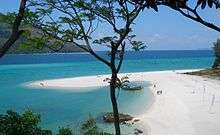
Tourism
Ko Lipe has three main beaches: Sunset Beach (Hat Pramong), Sunrise Beach (Hat Chao Ley), and Pattaya Beach. The calm, clear water makes Ko Lipe ideal for snorkeling, with 25 percent of the world's tropical fish species found in the area.
Environmental concerns
Development on the island is rapidly growing to meet the increase in tourism, leading to issues with waste management, wildlife conservation, and energy supplies. The parks department is trying to control the amount of building on Lipe as many developers have built resorts on National Park land. Upon arrival at Ko Lipe you must pay a National Park admission fee and environmental fee.[2]
References
- ↑ "Tarutao National Park; Geography". Thailand National Parks. Thailand Department of National Parks. Retrieved 2015-01-10.
- 1 2 "Tarutao National Park". Tourism Authority of Thailand (TAT). Retrieved 14 June 2016.
External links
| Wikivoyage has a travel guide for Ko Lipe. |
Coordinates: 6°29′N 99°18′E / 6.49°N 99.3°E