Komini Peak

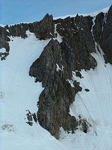
Komini Peak (Bulgarian: Vrah Komini \'vr&h ko-'mi-ni\) is a peak with an elevation of 774 m (2,539 ft) on the north slopes of Levski Peak, in the Tangra Mountains, in Livingston Island, Antarctica.
The peak has precipitous rocky western slopes and was first climbed by Lyubomir Ivanov from Camp Academia by way of its 212-m high western rock wall on 21 December 2004.
The feature is named after Komini Peak in Vitosha Mountain, Western Bulgaria.
Location
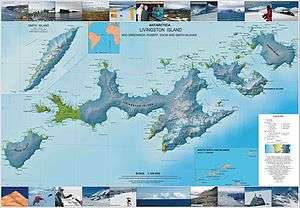
The peak is located at 62°39′10″S 60°07′05.7″W / 62.65278°S 60.118250°WCoordinates: 62°39′10″S 60°07′05.7″W / 62.65278°S 60.118250°W which is 1.16 km (0.72 mi) north of Levski Peak, 1.7 km (1.1 mi) northeast of Lyaskovets Peak, 1.54 km (0.96 mi) east of Zograf Peak and 1.35 km (0.84 mi) southeast of Lozen Nunatak, 540 m (590 yd) south of Ravda Peak, 1.71 km (1.06 mi) southwest of Nestinari Nunataks and 2.36 km (1.47 mi) west of Plana Peak (Bulgarian topographic survey Tangra 2004/05, and mapping in 2005 and 2009).
Maps
- L.L. Ivanov et al. Antarctica: Livingston Island and Greenwich Island, South Shetland Islands. Scale 1:100000 topographic map. Sofia: Antarctic Place-names Commission of Bulgaria, 2005.
- L.L. Ivanov. Antarctica: Livingston Island and Greenwich, Robert, Snow and Smith Islands. Scale 1:120000 topographic map. Troyan: Manfred Wörner Foundation, 2009.
References
- L.L. Ivanov, Livingston Island: Tangra Mountains, Komini Peak, west slope new rock route; Lyaskovets Peak, first ascent; Zograf Peak, first ascent; Vidin Heights, Melnik Peak, Melnik Ridge, first ascent, The American Alpine Journal, 2005, 312-315.
- SCAR Composite Antarctic Gazetteer.
This article includes information from the Antarctic Place-names Commission of Bulgaria which is used with permission.