Korab
| Korab | |
|---|---|
 Korab mountain range | |
| Highest point | |
| Peak | Mount Korab |
| Elevation | 2,764 m (9,068 ft) |
| Prominence | 2,169 metres (7,116 ft) |
| Coordinates | 41°47′25″N 20°32′48″E / 41.79028°N 20.54667°ECoordinates: 41°47′25″N 20°32′48″E / 41.79028°N 20.54667°E |
| Geography | |
| Countries | Albania and Republic of Macedonia |
| Geology | |
| Mountain type | Range |
| Type of rock | Limestone |
Korab (Albanian: 'Mali i Korabit', Macedonian: Korab/Кораб) is a mountain range in Albania and Republic of Macedonia. The highest peak is Mount Korab (2764 m), which is the highest point of both countries.[1] In Albania the range issometimes called the Vargu Lindor (Eastern range), but this term usually encompasses mountains further north, such as Koritnik and Gjallica.
Geography
The Korab range stretches through the Dibër region for over 40 km in a north-south direction, between the river valleys of the Black Drin and its tributary the Radika. It is located near the tripoint of Albania, Macedonia, and Kosovo, southwest of the Šar Mountains. The ridge which forms the Albanian-Macedonian border almost entriely exceeds 2000 metres in height. The valley of the Drin lies around 400 metres to the west, the bed of the Radika at about 1000 metres. The range is part of the remaining range of the Balkan lynx.[2]
In addition to Mount Korab, there is another peak, almost as tall as it. To the north of this double-peak there are many other nameless peaks of a similar height. Korab-Pforte (Maja Portat e Korabit/Mala Korapska Vrata) lies around 2 km southwest of Mount Korab and is almost as tall as the main mountain, at 2727 metres. A few hundred metres further south, there is another peak, Maja e Moravës, which is 2718 metres high.
South of the complex of peaks around Mount Korab, there are other large mountains: Mali i Gramës (2345 m) and Dešat's Velivar summit (2375 m). After that, the range falls away to the city of Debar and the Debar Lake.[3] The city of Peshkopi is to the southwest of Mali i Gramës and has geothermal baths.
History
The word "Korab" is originally Slavic and derives from a pre-Christian sea god. Because the mountain range forms the eastern border of Albania, it is also known in Albanian as Vargu Lindor (Eastern Range). But this usually refers to the entire 70 km long mountain range on the east bank of the Black Drin, from Koritnik to Kukës. In scholarship, the Korab range and the Šar mountains are often referred to together as the Šar-Korab-Massif.
During the Balkan Wars, there was conflict in the region. There may still be landmines in the Korab range. In the border area, which saw battles between the Macedonian army and Albanian separatists until very recently, smuggling is rife.
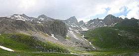
 The range from the Macedonian side
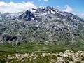 Fusha e Korabit
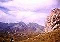
 Lake Grama
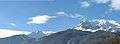 Dešat
Dešat Gypsum near the Mali i Bardhë
References
- ↑ "2007 Trip Report".
- ↑ euronatur.org: Projekt Luchs, Projektbericht 2012 - 2013
- ↑ Perikli Qiriazi (2006). Gjeografia fizike e Shqipërisë. Tirana: Shtëpia botuese e librit universitar. p. 189. ISBN 99927-0-397-0.
External links
| Wikimedia Commons has media related to Mount Korab. |
- Mountain Club Korab - the Macedonian climbing club organises the international ascent of Golem Korab with thousands of participants, Macedonia's largest sporting activity.
- SummitPost.org
- Account of an ascent with helpful information