Korea Strait
| Korea Strait | |
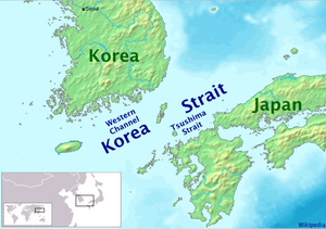 Map showing the Korea Strait. | |
| Japanese name | |
|---|---|
| Kanji | 対馬海峡 |
| Hiragana | つしまかいきょう |
| Revised Hepburn | Tsushima Kaikyō |
| North Korean name | |
| Chosŏn'gŭl | 조선해협 |
| Hancha | 朝鮮海峽 |
| Revised Romanization | Joseon Haehyeop |
| McCune–Reischauer | Chosŏn Haehyŏp |
| South Korean name | |
| Hangul | 대한해협 |
| Hanja | 大韓海峽 |
| Revised Romanization | Daehan Haehyeop |
| McCune–Reischauer | Taehan Haehyŏp |
The Korea Strait is a sea passage between Japan and South Korea, connecting the East China Sea and the Sea of Japan in the northwest Pacific Ocean. The strait is split by the Tsushima Island into the western channel and the Tsushima Strait (eastern channel).
Geography
To the north it is bounded by the southern coast of the Korean Peninsula, and to the south by the southwestern Japanese islands of Kyūshū and Honshū. It is about 200 km (120 mi) wide and averages about 90 to 100 meters (300 ft) deep.
Tsushima Island divides the Korea Strait into the western channel and the Tsushima Strait. The western channel is deeper (up to 227 meters) and narrower than the Tsushima Strait.
Currents
A branch of the Kuroshio Current passes through the strait. Its warm branch is sometimes called the Tsushima Current. Originating along the Japanese islands this current passes through the Sea of Japan then divides along either shore of Sakhalin Island, eventually flowing into the northern Pacific Ocean via the strait north of Hokkaidō and into the Sea of Okhotsk north of Sakhalin Island near Vladivostok. The water-mass characteristics vary widely because of the low-salinity waters of the southeast coasts of Korea and China.
Economic significance
Numerous international shipping lanes pass through the strait, including those carrying much of the traffic bound for the ports of southern South Korea. Both South Korea and Japan have restricted their territorial claims in the strait to 3 nautical miles (5.6 km) from shore, so as to permit free passage through it.
Passenger ferries travel numerous routes across the strait. Commercial ferries run from Busan, South Korea to Japanese ports including Fukuoka, Tsushima, Shimonoseki, and Hiroshima. Ferries also connect Tsushima Island with Fukuoka, and South Korea's Jeju Island with the Korean mainland. Ferries connecting Busan and Japanese cities with ports in China also traverse the strait.
Japan's territorial waters extend to three nautical miles (5.6 km) into the strait instead of the usual twelve, reportedly to allow nuclear-armed United States Navy warships and submarines to transit the strait without violating Japan's prohibition against nuclear weapons in its territory.[1]
Naming of the strait
| Korean Peninsula - Kyushu | Korean Peninsula - Tsushima Island | Tsushima Island - Kyushu | |
|---|---|---|---|
| International name (commonly used in English) |
Korea Strait | Korea Strait Western Channel | Tsushima Strait or Korea Strait Eastern Channel |
| North Korean name | 조선해협 - 朝鮮海峡 Chosŏn Haehyŏp "Korea Strait" | 부산해협 - 釜山海峡 Pusan Haehyŏp "Busan Strait" | 쯔시마해협 - 對馬海峡 Tchŭsima Haehyŏp "Tsushima Strait" |
| South Korean name | 대한해협 - 大韓海峡 Daehan Haehyeop "Korea Strait" | 부산해협 - 釜山海峡 Busan Haehyeop "Busan Strait" | 쓰시마해협 - 對馬海峡 Sseusima Haehyeop "Tsushima Strait" |
| Japanese name | 対馬海峡 Tsushima Kaikyō "Tsushima Strait" | 朝鮮海峡 or 対馬海峡西水道 Chōsen Kaikyō or Tsushima Kaikyō Nishi-suidō "Korea Strait" or "Tsushima Strait Western Channel" | 対馬海峡 or 対馬海峡東水道 Tsushima Kaikyō or Tsushima Kaikyō Higashi-suidō "Tsushima Strait" or "Tsushima Strait Eastern Channel" |
Historic impact
Land bridge
- See article: Land bridge
During the Pleistocene glacial cycles, the Korea and the Bering Straits, and the Yellow Sea were often narrowed and the Japanese islands may at times have been connected to the Eurasian Continent through the Korean Peninsula or Sakhalin. At times, the Sea of Japan was said to be a frozen inner lake due to the lack of warm Tsushima Current and various plants and large animals, such as the Palaeoloxodon naumanni are believed to have spread into Japan.[2]
Early history
Historically, these narrows served as a highway for high risk voyages. The shortest distance between Busan, South Korea, and the Tsushima Island is about 50 km, as is the shortest distance from Tsushima to Iki Island, Japan.
Japan's Yamatai periodically sent year-long embassies to Chinese dynasties, believed to have traveled through the Korean strait and the Korean peninsula, to obtain the latest culture and technologies. In the 6th century, Buddhism (Mahāyāna Buddhism) was transmitted by Baekje people to the easternmost Japan of the Emperor Kimmei's era over this strait (See also: East Asian Buddhism and Buddhism in Japan).
Mongolian invasion
- See main article: Mongol invasions of Japan
A joint Mongol-Korea fleet crossed this strait and attempted to invade Japan in 1274 and 1281. The force severely ravaged the Tsushima Island on the way to Japan but failed to defeat Japan. The typhoon (kamikaze, usually translated as "divine wind") is said to have saved Japan from a Mongol invasion fleet led by Kublai Khan in 1281.
Wokou and Ōei Invasion
- See main article: Wokou and Ōei Invasion
After the Mongolian invasion ravaged Tsushima, it became a base of the Wokou (Japanese pirates). The Korean Joseon Dynasty sent a fleet to Tsushima in 1419 for the suppression of Wokou activity. Korea subsequently agreed to grant the Japanese limited trading privileges.
Battle of Tsushima
- See main article: Battle of Tsushima
The Battle of Tsushima, fought between the Japanese and Russian navies on May 27 and May 28, 1905, took place in the Tsushima Strait part of the Korea Strait, east of the north part of Tsushima and due north of Iki Island. The Russian fleet was virtually destroyed by the Japanese.
Battle of Korea Strait
The Battle of Korea Strait was a naval battle fought on the first day of the Korean War, 25-26 June 1950, between the navies of South Korea and North Korea. A North Korean troop transport carrying hundreds of soldiers attempted to land its cargo near Busan but was encountered by a South Korean patrol ship and sunk. It was one of the first surface actions of the war and resulted in an important South Korean victory.[3][4]
Future
The possibility of a Japan–Korea Undersea Tunnel or bridge, similar to the Channel Tunnel running under the English Channel between France and the United Kingdom, has been discussed for decades.
See also
- List of Japan-related topics
- Geography of Japan
- List of Korea-related topics
- Russo-Japanese War
- Tsushima City
References
- ↑ Kyodo News, "Japan left key straits open for U.S. nukes", Japan Times, June 22, 2009.
- ↑ Park, S.-C.; Yoo, D.-G., Lee, C.-W., Lee, E.-I. (26 September 2000). "Last glacial sea-level changes and paleogeography of the Korea (Tsushima) Strait". Geo-Marine Letters. 20 (2): 64–71. doi:10.1007/s003670000039. Cite uses deprecated parameter
|coauthors=(help) - ↑ J. Marolda, Edward (26 August 2003). "Naval Battles". Naval History & Heritage Command. Retrieved 20 November 2010.
- ^ For example, a) "Low-Frequency Current Observations in the Korea/Tsushima Strait". W. J. Teague, G. A. Jacobs, H. T. Perkins, J. W. Book, K.-I. Chang, M.-S. Suk Journal of Physical Oceanography 32, 1621–1641 (2001). b) "Tsushima". Russo-Japanese War Research Society
- ^ "Nautical Charts of SE Japan Sea". Japan Hydrographic Association
- ^ "List of National and Quasi-national Parks, Japan #48 Iki-Tsushima". Ministry of the Environment, Japan
- ^ "The Republic of Korea's Maritime Boundaries, page 18". Retrieved June 23, 2005.
- ^ "Designated Area of Japan". Hydrographic and Oceanographic Department, Japan Coast Guard
External links
Coordinates: 34°35′58″N 129°47′48″E / 34.59944°N 129.79667°E