Kornice
| Kornice | |
| Village | |
| Country | Czech Republic |
|---|---|
| Region | Pardubice |
| District | Svitavy |
| Little District | Litomyšl |
| Elevation | 383 m (1,257 ft) |
| Coordinates | CZ 49°53′N 16°18′E / 49.883°N 16.300°ECoordinates: CZ 49°53′N 16°18′E / 49.883°N 16.300°E |
| Area | 2.87 km2 (1.11 sq mi) |
| Population | 151 |
| Density | 53/km2 (137/sq mi) |
| Timezone | CET (UTC+1) |
| - summer (DST) | CEST (UTC+2) |
| Postal code | 570 01 |
  Location in the Czech Republic | |
| Website: http://kornice.cz | |
Kornice (German: Kornitz) is a small village, administratively a part of the town of Litomyšl in the Czech Republic. It is located on the Hlavňov hill (383 metres above sea level). There live about 150 inhabitants.
History

People used to live here from the last Ice Age. At the end of 12th century are recorded a village named Domašice and a field next to it called Nakorniceh. Domašice was probably in the 13th century moved to the villages current location. Kornice is for the first time mentioned in 1347. It was a part of the domain of Litomyšl until 1848. Kornice was from 1850 administratively a part of Velké Sedliště but since 1898 had its own municipal office. From 1976 it is officially a part of the town Litomyšl.
Sights
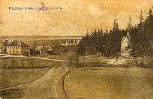
There are two in the Gothic Revival style constructed chapels from 1873 and 1886. The first one is in the village square and the other one in the forest Končiny above an allegedly healing spring.
References
- History of Kornice (in Czech) http://www.kornice.cz/pics/download/kornice2.3.pdf