Koszalin Voivodeship
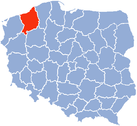
Koszalin Voivodeship (2) (Polish: województwo koszalińskie) – a unit of administrative division and local government in Poland in the years 1975–98, superseded by West Pomeranian Voivodeship.
Capital city: Koszalin
Area: 8.500 km²
Statistics (1 January 1992):
Population: 508.200 inhabitants
Population density: 60 inhabitants/km²
Administrative division: 35 communes
Number of cities and towns (urban communes): 17
Major cities and towns (population 1980):
- Koszalin (93.500);
- Kołobrzeg (38.200);
- Szczecinek (32.900);
- Białogard (22.500);
- Świdwin (14.000);
- Darłowo (13.400);
- Złocieniec (12.200).
Koszalin Voivodeship (1)[1] – a unit of administrative division and local government in Poland in years 1950–75, created from eastern part of Szczecin Voivodeship, superseded by the voivodeships of Koszalin (2), Slupsk and Pila.
Capital city: Koszalin
Area: 18.104 km²
Population (31 December 1970): 793.700 inhabitants (399.300 men + 394.400 wemen)
Urban population (31 December 1970): 392.200 (49,5%)
Population density (31 December 1970): 44 inhabitants/km²
Administrative division (1 January 1971): 15 counties (13 land + 2 city counties)
Administrative division (1 January 1971): 23 towns + 154 communities
List of counties in 1950–1975:
English county name, Polish county name, capital city
- Koszalin City, miasto Koszalin
- Słupsk City, miasto Słupsk
- Białogard County, powiat białogardzki, Białogard
- Bytów County, powiat bytowski, Bytów
- Człuchów County, powiat człuchowski, Człuchów
- Drawsko Pomorskie County, powiat drawski, Drawsko Pomorskie
- Kołobrzeg County, powiat kołobrzeski, Kołobrzeg
- Koszalin County, powiat koszaliński, Koszalin
- Miastko County, powiat miastecki, Miastko
- Sławno County, powiat sławieński, Sławno
- Słupsk County, powiat słupski, Słupsk
- Szczecinek County, powiat szczecinecki, Szczecinek
- Wałcz County, powiat wełecki, Wałcz
- Złotów County, powiat złotowski, Złotów
New counties established 1950–1975:
- Świdwin County, powiat świdwiński, Świdwin, previously part of Białogard County
See also
References
Coordinates: 54°11′17″N 16°10′39″E / 54.188049°N 16.177497°E