Kotlas
| Kotlas (English) Котлас (Russian) | |
|---|---|
| - Town[1] - | |
 Former headquarters of the Pechora Railway in Kotlas | |
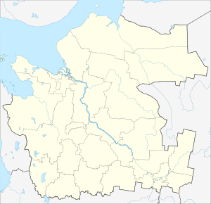
.svg.png) Location of Arkhangelsk Oblast in Russia | |
 Kotlas | |
|
| |
_2007.png) |
|
|
| |
| Administrative status (as of June 2013) | |
| Country | Russia |
| Federal subject | Arkhangelsk Oblast[1] |
| Administratively subordinated to | town of oblast significance of Kotlas[2] |
| Administrative center of | town of oblast significance of Kotlas,[2] Kotlassky District[1] |
| Municipal status (as of April 2014) | |
| Urban okrug | Kotlas Urban Okrug[3] |
| Administrative center of | Kotlas Urban Okrug,[3] Kotlassky Municipal District,[3] Cheryomushskoye Rural Settlement[3] |
| Statistics | |
| Area (urban okrug) (January 2011) | 68.039 km2 (26.270 sq mi)[4] |
| Population (2010 Census) | 60,562 inhabitants[5] |
| - Rank in 2010 | 271st |
| Density | 890/km2 (2,300/sq mi)[6] |
| Time zone | MSK (UTC+03:00)[7] |
| Town status since | June 16, 1917 |
| Postal code(s)[8] | 165300–165306, 165308, 165309, 165311–165313, 165398, 165399 |
| Dialing code(s) | +7 81837 |
|
| |
| Kotlas on Wikimedia Commons | |
Kotlas (Russian: Ко́тлас) is a town in Arkhangelsk Oblast, Russia, located at the confluence of the Northern Dvina and Vychegda Rivers. Population: 60,562 (2010 Census);[5] 60,647 (2002 Census);[9] 68,021 (1989 Census).[10]
Kotlas is the third largest town of Arkhangelsk Oblast in terms of population (behind Arkhangelsk and Severodvinsk) and an important transport hub.
History
The place was probably inhabited from ancient times, but was only granted official town status by the Provisional Government of Russia on June 16, 1917, when it was a part of Vologda Governorate. In 1918, the area was transferred to the newly formed Northern Dvina Governorate, and in 1924 the uyezds were abolished in favor of the new divisions, the districts (raions). Kotlassky District was formed on June 25, 1924.[11] In 1929, Northern Dvina Governorate was merged into Northern Krai, which in 1936 was transformed into Northern Oblast. In 1937, Northern Oblast was split into Arkhangelsk Oblast and Vologda Oblast. Kotlassky District remained in Arkhangelsk Oblast ever since.
Gulag
During the 1930s, Kotlas became a place to which kulaks were deported and made to work in the forestry industry. It was managed by the Kotlaslag division of Gulag. Later, it hosted all possible categories of people repressed during the Stalin era. A significant population of Poles existed in the area, with whole Polish villages resettled here in 1920s and 1930s.
Labor camps existed within the territory of the city until 1953. Besides logging and paper industry, the occupation of inmates were plant, housing, bridge, and railroad construction. Most of camps were unguarded barrack settlements. In addition, Kotlas was a major transit point for deportees transferred further to the north and east, since it was a railroad terminus. There is a Kotlas branch of the Sovest (Conscience) organization, which seeks to preserve the memory of those times and seek compensation for victims.
Pechora railway
The further development of Kotlas is due to the construction of Pechora Railway. Already from 1899 Kotlas was connected by a railway line with Vyatka (currently Kirov), which was heavily used for the cargo transport of goods to and from the Northern Dvina River. In 1940, the construction of the railroad connecting Konosha (on the railway stretch between Moscow and Arkhangelsk) to Vorkuta started. The railroad was needed to transport coal, timber, and later oil from the Komi Republic. The headquarters of this railroad were opened in Kotlas. In the same year, Kotlas became a separate administrative unit. In December 1941, the road was completed, and from 1942, the regular service started. Kotlas thus became an important transport hub. The headquarters of the Pechora Railway were located in Kotlas until 1959, when the railway was merged into the Northern Railway.[12]
Administrative and municipal status
Within the framework of administrative divisions, Kotlas serves as the administrative center of Kotlassky District, even though it is not a part of it.[1] As an administrative division, it is, together with one work settlement (Vychegodsky) and two rural localities, incorporated separately as the town of oblast significance of Kotlas—an administrative unit with the status equal to that of the districts.[2] As a municipal division, the town of oblast significance of Kotlas is incorporated as Kotlas Urban Okrug.[3]
Within the framework of municipal divisions, Kotlas also serves as the administrative center of Cheryomushskoye Rural Settlement, even though it is not a part of it.[3]
Economy
Kotlas is a center of timber industry and an important river port and a railroad center (standing on the railroad connecting central Russia with the Komi Republic).
The Northern Dvina and the Vychegda Rivers are navigable; there is regular passenger navigation on the Vychegda. Roads connect Kotlas with Veliky Ustyug (and eventually Vologda and Kostroma) to the South, Syktyvkar to the East, and Krasnoborsk (eventually Arkhangelsk) to the North. There is regular passenger bus traffic originating from Kotlas.
Kotlas is an important railway hub, where the railway to Kirov branches off south-east from the main railway, connecting Konosha and Vorkuta.
Kotlas is served by Kotlas Airport and is home to Savatiya air base.
Culture and recreation
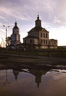
The Church of St. Stephan of Perm was built in 1788, and the adjacent bell-tower was built in 1825. Both are protected at the local level as architecture monuments, as well as Narodny Dom, a wooden house built in the beginning of 20th century.[13]
Climate
| Climate data for Kotlas | |||||||||||||
|---|---|---|---|---|---|---|---|---|---|---|---|---|---|
| Month | Jan | Feb | Mar | Apr | May | Jun | Jul | Aug | Sep | Oct | Nov | Dec | Year |
| Average high °C (°F) | −10 (14) |
−9 (16) |
−1 (30) |
6 (43) |
14 (57) |
20 (68) |
22 (72) |
20 (68) |
12 (54) |
4 (39) |
−2 (28) |
−7 (19) |
5 (41) |
| Daily mean °C (°F) | −14 (7) |
−12 (10) |
−6 (21) |
1 (34) |
8 (46) |
14 (57) |
17 (63) |
14 (57) |
8 (46) |
1 (34) |
−4 (25) |
−10 (14) |
1 (34) |
| Average low °C (°F) | −18 (0) |
−17 (1) |
−10 (14) |
−2 (28) |
3 (37) |
8 (46) |
11 (52) |
9 (48) |
4 (39) |
−1 (30) |
−7 (19) |
−14 (7) |
−2 (28) |
| Average precipitation mm (inches) | 32 (1.26) |
22 (0.87) |
21 (0.83) |
37 (1.46) |
43 (1.69) |
56 (2.2) |
72 (2.83) |
68 (2.68) |
50 (1.97) |
53 (2.09) |
43 (1.69) |
39 (1.54) |
535 (21.06) |
| Source: Weatherbase[14] | |||||||||||||
Sports
Salyut is the local bandy club. Alexandr Tyukavin, a notable player, voted to be the third best player of the Russian National Championship 2011–2012, was born in Kotlas.[15][16] In 2014 he was awarded a prize from the International Fair Play Committee.
Twin towns and sister cities
Kotlas is twinned with:
References
Notes
- 1 2 3 4 Государственный комитет Российской Федерации по статистике. Комитет Российской Федерации по стандартизации, метрологии и сертификации. №ОК 019-95 1 января 1997 г. «Общероссийский классификатор объектов административно-территориального деления. Код 11 410 008», в ред. изменения №259/2014 от 12 декабря 2014 г.. (State Statistics Committee of the Russian Federation. Committee of the Russian Federation on Standardization, Metrology, and Certification. #OK 019-95 January 1, 1997 Russian Classification of Objects of Administrative Division . Code 11 410 008, as amended by the Amendment #259/2014 of December 12, 2014. ).
- 1 2 3 Oblast Law #65-5-OZ
- 1 2 3 4 5 6 Oblast Law #258-vneoch.-OZ
- ↑ Паспорт города. Котлас (in Russian). Администрация МО "Котлас". 2008. Retrieved November 14, 2014.
- 1 2 Russian Federal State Statistics Service (2011). "Всероссийская перепись населения 2010 года. Том 1" [2010 All-Russian Population Census, vol. 1]. Всероссийская перепись населения 2010 года (2010 All-Russia Population Census) (in Russian). Federal State Statistics Service. Retrieved June 29, 2012.
- ↑ The value of density was calculated automatically by dividing the 2010 Census population by the area specified in the infobox. Please note that this value may not be accurate as the area specified in the infobox does not necessarily correspond to the area of the entity proper or is reported for the same year as the population.
- ↑ Правительство Российской Федерации. Федеральный закон №107-ФЗ от 3 июня 2011 г. «Об исчислении времени», в ред. Федерального закона №271-ФЗ от 03 июля 2016 г. «О внесении изменений в Федеральный закон "Об исчислении времени"». Вступил в силу по истечении шестидесяти дней после дня официального опубликования (6 августа 2011 г.). Опубликован: "Российская газета", №120, 6 июня 2011 г. (Government of the Russian Federation. Federal Law #107-FZ of June 31, 2011 On Calculating Time, as amended by the Federal Law #271-FZ of July 03, 2016 On Amending Federal Law "On Calculating Time". Effective as of after sixty days following the day of the official publication.).
- ↑ Почта России. Информационно-вычислительный центр ОАСУ РПО. (Russian Post). Поиск объектов почтовой связи (Postal Objects Search) (Russian)
- ↑ Russian Federal State Statistics Service (May 21, 2004). "Численность населения России, субъектов Российской Федерации в составе федеральных округов, районов, городских поселений, сельских населённых пунктов – районных центров и сельских населённых пунктов с населением 3 тысячи и более человек" [Population of Russia, Its Federal Districts, Federal Subjects, Districts, Urban Localities, Rural Localities—Administrative Centers, and Rural Localities with Population of Over 3,000] (XLS). Всероссийская перепись населения 2002 года [All-Russia Population Census of 2002] (in Russian). Retrieved August 9, 2014.
- ↑ Demoscope Weekly (1989). "Всесоюзная перепись населения 1989 г. Численность наличного населения союзных и автономных республик, автономных областей и округов, краёв, областей, районов, городских поселений и сёл-райцентров" [All Union Population Census of 1989: Present Population of Union and Autonomous Republics, Autonomous Oblasts and Okrugs, Krais, Oblasts, Districts, Urban Settlements, and Villages Serving as District Administrative Centers]. Всесоюзная перепись населения 1989 года [All-Union Population Census of 1989] (in Russian). Институт демографии Национального исследовательского университета: Высшая школа экономики [Institute of Demography at the National Research University: Higher School of Economics]. Retrieved August 9, 2014.
- ↑ История района (in Russian). Котласский муниципальный район. Retrieved May 26, 2011.
- ↑ Северная железная дорога (in Russian). www.railway.te.ua. Retrieved August 9, 2011.
- ↑ Памятники истории и культуры народов Российской Федерации (in Russian). Russian Ministry of Culture. Retrieved 2 June 2016.
- ↑ "Weatherbase: Historical Weather for Kotlas". Retrieved August 25, 2011.
- ↑ "Сергей Ломанов – лучший игрок XX Чемпионата России" (in Russian). bandynet.ru. Retrieved April 2, 2012.
- ↑ Тюкавин Александр Васильевич (in Russian). Russian Bandy Federation. Retrieved December 31, 2013.
- ↑ "Miasta Partnerskie". Retrieved May 1, 2014.
Sources
- Архангельское областное Собрание депутатов. Областной закон №65-5-ОЗ от 23 сентября 2009 г. «Об административно-территориальном устройстве Архангельской области», в ред. Областного закона №232-13-ОЗ от 16 декабря 2014 г. «О внесении изменений в отдельные Областные Законы в сфере осуществления местного самоуправления и взаимодействия с некоммерческими организациями». Вступил в силу через десять дней со дня официального опубликования. Опубликован: "Волна", №43, 6 октября 2009 г. (Arkhangelsk Oblast Council of Deputies. Oblast Law #65-5-OZ of September 23, 2009 On the Administrative-Territorial Structure of Arkhangelsk Oblast, as amended by the Oblast Law #232-13-OZ of December 16, 2014 On Amending Various Oblast Laws Dealing with the Process of Municipal Self-Government and Relations with Non-Profit Organizations. Effective as of the day which is ten days after the official publication.).
- Архангельское областное Собрание депутатов. Областной закон №258-внеоч.-ОЗ от 23 сентября 2004 г. «О статусе и границах территорий муниципальных образований в Архангельской области», в ред. Областного закона №224-13-ОЗ от 16 декабря 2014 г. «Об упразднении отдельных населённых пунктов Соловецкого района Архангельской области и о внесении изменения в статью 46 Областного закона "О статусе и границах территорий муниципальных образований в Архангельской области"». Вступил в силу со дня официального опубликования. Опубликован: "Волна", №38, 8 октября 2004 г. (Arkhangelsk Oblast Council of Deputies. Oblast Law #258-vneoch.-OZ of September 23, 2004 On the Status and Borders of the Territories of the Municipal Formations in Arkhangelsk Oblast, as amended by the Oblast Law #224-13-OZ of December 16, 2014 On Abolishing Several Inhabited Localities in Solovetsky District of Arkhangelsk Oblast and on Amending Article 46 of the Oblast Law "On the Status and Borders of the Territories of the Municipal Formations in Arkhangelsk Oblast". Effective as of the day of the official publication.).
External links
Administrative center: Arkhangelsk | ||
| Cities and towns | .png) | |
| Administrative districts | ||