Kraai River
| Kraai River | |
| River | |
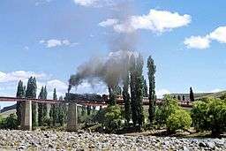 A special tourist train steaming across the Kraai River bridge near Lady Grey in 1979 | |
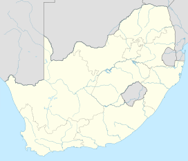
| Country | South Africa |
|---|---|
| Province | Eastern Cape |
| Part of | Orange River |
| Tributaries | |
| - left | Karnmelkspruit |
| - right | Bell River |
| Source | |
| - location | Moshesh's Ford |
| - elevation | 1,845 m (6,053 ft) |
| - coordinates | 30°51′9″S 27°46′40″E / 30.85250°S 27.77778°E |
| Mouth | |
| - location | Aliwal North, Eastern Cape, South Africa |
| - elevation | 1,340 m (4,396 ft) |
| - coordinates | 30°40′2″S 26°45′6″E / 30.66722°S 26.75167°ECoordinates: 30°40′2″S 26°45′6″E / 30.66722°S 26.75167°E |
 | |
The Kraai River ("Crow River") is a tributary of the Orange or Gariep River that flows near Barkly East in the Eastern Cape, South Africa.
The Kraai River originates in the mountains south of Lesotho and flows westward from the confluence of the Bell River and the Sterkspruit at Moshesh's Ford at 30°51′09″S 27°46′40″E / 30.852558°S 27.7777527°E all the way to Aliwal North, where it joins the Orange River at 30°40′02″S 26°45′06″E / 30.66715°S 26.75177°E.[1]
The river flows almost entirely over sandstone rocks of the Clarens Formation.
The Kraai is fishable, containing Rainbow Trout, Brown Trout and Smallmouth Yellowfish.[2]
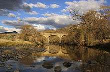
In 1881[3] a sandstone[4] arch bridge called the J W Sauer bridge was completed over the river. The bridge linked communities in the Kraai River basin with Aliwal North. The Sauer bridge and the Loch Bridge on the farm Tyger Krantz, are now Provincial Heritage sites.[5][6]
Major tributaries
- Bell River and a tributary of the Bell, the Kloppershoekspruit
- Sterkspruit, its tributaries are the Bokspruit and Riflespruit
- Joggemspruit
- Langkloofspruit
- Diepspruit and its tributary, the Three Drifts Stream
- Carlisleshoekspruit and the Maartenshoekspruit
- Klein Wildebeestspruit
- Saalboomspruit and its tributary, the Vaalhoekspruit
- Karnmelkspruit
See also
References
- ↑ Physiography of the Kraai River Catchment WalkerBouts.co.za
- ↑ "Fly Fishing" wildmountainadventures.co.za
- ↑ "Stone Arch Bridges Of The Northeast Cape" maclear.co.za
- ↑ "Exploring the Eastern Cape’s bridging legacy" farmersweekly.co.za
- ↑ "J W Sauer Bridge, Kraai River, Aliwal North District" sahra.org.za
- ↑ "Loch Bridge, Kraai River, Barkly East District" sahra.org.za