Lézarde
| Lézarde | |
|---|---|
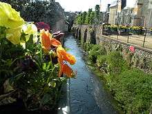 The Lézarde in Montivilliers | |
| Country | France |
| Basin | |
| Main source |
Pays de Caux 106 m (348 ft) |
| River mouth | Seine |
| Progression | Seine→ English Channel |
| Basin size | 116 km2 (45 sq mi) |
| Physical characteristics | |
| Length | 14.2 km (8.8 mi) |
| Discharge |
|
The river Lézarde is one of the rivers that flow from the plateau of the southern Pays de Caux in the Seine-Maritime département of Haute-Normandie into the Seine.
The river rises at Saint-Martin-du-Bec and passes Notre-Dame-du-Bec, Rolleville, Épouville, Montivilliers and joins the Seine at Harfleur.
Economy
In the past, the river was host to many watermills that powered machinery to process both wheat and oil.
See also
External links
- The Lézarde on the Sandre website (French)
- Accès aux villes et villages de France du Quid (French)
- French Geography website (French)
Notes
- This article is based on the equivalent article from the French Wikipedia, consulted on October 8th 2008.
Coordinates: 49°30′N 0°12′E / 49.500°N 0.200°E
This article is issued from Wikipedia - version of the 6/3/2016. The text is available under the Creative Commons Attribution/Share Alike but additional terms may apply for the media files.