Lühe (river)
This article is about the river Lühe in Lower Saxony. For the collective municipality, see Lühe. For the locality of Jork, see Lühe (Jork). For the river Luhe in Bavaria, see Luhe (Naab).
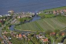 | |
| Lühe with the Lühe Tidal Barrage at its mouth into the Elbe in Lühe village, photo 2012 | |
| Location | Lower Saxony, Germany |
|---|---|
| Reference no. | DE: 596 |
| Length | 12.67 km (7.87 mi) [1] |
| Source | Confluence of the Aue and Landwettern in Horneburg 53°30′43.5″N 9°35′27.25″E / 53.512083°N 9.5909028°E |
| Mouth | Near Grünendeich into the Elbe 53°34′18.5″N 9°38′3″E / 53.571806°N 9.63417°ECoordinates: 53°34′18.5″N 9°38′3″E / 53.571806°N 9.63417°E |
| Basin | Elbe |
| Progression | Elbe → North Sea |
| Navigable | 12.7 km (7.9 mi) |
The Lühe (Low Saxon: Lü(h)) is a river in northern Germany in the district of Stade in Lower Saxony, Germany. Formed at Horneburg by the confluence of the rivers Aue and Landwettern, it flows through the Altes Land, then reaching the lower reaches of the Elbe near Grünendeich. It has a length of about 12.6 kilometres (7.8 mi).
Course
The Lühe is formed by the confluence of the rivers Aue and Landwettern in Horneburg. Its course forms the border between the Second Mile and the Third Mile (territorial subdivisions) of the Altes Land. The Lühe flows through the towns and villages of:

Lühe ferryhouse, 1900
...emptying near Lühe, a locality of Jork, into the Elbe.
References
- ↑ Längen (in km) der Hauptschifffahrtswege (Hauptstrecken und bestimmte Nebenstrecken) der Binnenwasserstraßen des Bundes, Wasser- und Schifffahrtsverwaltung des Bundes
External links
 Media related to Lühe (river) at Wikimedia Commons
This article is issued from Wikipedia - version of the 11/15/2016. The text is available under the Creative Commons Attribution/Share Alike but additional terms may apply for the media files.