La Chapelle-Cécelin
| La Chapelle-Cécelin | |
|---|---|
|
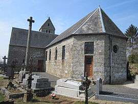
The church of Saint-Cyr-et-Sainte-Julitte | |
 La Chapelle-Cécelin | |
|
Location within Normandy region  La Chapelle-Cécelin | |
| Coordinates: 48°48′42″N 1°09′33″W / 48.8117°N 1.1592°WCoordinates: 48°48′42″N 1°09′33″W / 48.8117°N 1.1592°W | |
| Country | France |
| Region | Normandy |
| Department | Manche |
| Arrondissement | Avranches |
| Canton | Saint-Pois |
| Intercommunality | Communauté de communes du canton de Saint-Pois |
| Government | |
| • Mayor (2008–2014) | Françoise Mauduit |
| Area1 | 5.22 km2 (2.02 sq mi) |
| Population (2006)2 | 203 |
| • Density | 39/km2 (100/sq mi) |
| Time zone | CET (UTC+1) |
| • Summer (DST) | CEST (UTC+2) |
| INSEE/Postal code | 50121 / 50800 |
| Elevation |
160–242 m (525–794 ft) (avg. 236 m or 774 ft) |
|
1 French Land Register data, which excludes lakes, ponds, glaciers > 1 km² (0.386 sq mi or 247 acres) and river estuaries. 2 Population without double counting: residents of multiple communes (e.g., students and military personnel) only counted once. | |
La Chapelle-Cécelin is a commune in the Manche department in Normandy in north-western France.
See also
| Wikimedia Commons has media related to La Chapelle-Cécelin. |
This article is issued from Wikipedia - version of the 7/5/2016. The text is available under the Creative Commons Attribution/Share Alike but additional terms may apply for the media files.