La Flocellière
| La Flocellière | ||
|---|---|---|
|
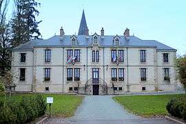
The town hall in La Flocellière | ||
| ||
 La Flocellière | ||
|
Location within Pays de la Loire region  La Flocellière | ||
| Coordinates: 46°49′59″N 0°51′34″W / 46.8331°N 0.8594°WCoordinates: 46°49′59″N 0°51′34″W / 46.8331°N 0.8594°W | ||
| Country | France | |
| Region | Pays de la Loire | |
| Department | Vendée | |
| Arrondissement | Fontenay-le-Comte | |
| Canton | Les Herbiers | |
| Intercommunality | Pays de Pouzauges | |
| Government | ||
| • Mayor (2008–2014) | Antoine Hériteau | |
| Area1 | 29.19 km2 (11.27 sq mi) | |
| Population (2006)2 | 2,305 | |
| • Density | 79/km2 (200/sq mi) | |
| Time zone | CET (UTC+1) | |
| • Summer (DST) | CEST (UTC+2) | |
| INSEE/Postal code | 85090 / 85700 | |
| Elevation | 99–272 m (325–892 ft) | |
|
1 French Land Register data, which excludes lakes, ponds, glaciers > 1 km² (0.386 sq mi or 247 acres) and river estuaries. 2 Population without double counting: residents of multiple communes (e.g., students and military personnel) only counted once. | ||
La Flocellière is a former commune in the Vendée department in the Pays de la Loire region in western France. On 1 January 2016, it was merged into the new commune of Sèvremont.[1]
See also
References
- ↑ Arrêté préfectoral 18 December 2015
| Wikimedia Commons has media related to La Flocellière. |
This article is issued from Wikipedia - version of the 3/10/2016. The text is available under the Creative Commons Attribution/Share Alike but additional terms may apply for the media files.