La Mouche, Manche
| La Mouche | |
|---|---|
|
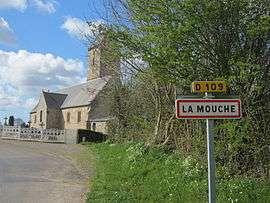
Entrance to the village | |
 La Mouche | |
|
Location within Normandy region  La Mouche | |
| Coordinates: 48°47′39″N 1°20′55″W / 48.7942°N 1.3486°WCoordinates: 48°47′39″N 1°20′55″W / 48.7942°N 1.3486°W | |
| Country | France |
| Region | Normandy |
| Department | Manche |
| Arrondissement | Avranches |
| Canton | La Haye-Pesnel |
| Intercommunality | Communauté de communes du Pays hayland |
| Government | |
| • Mayor (2008–2014) | Marie-Claude Corbin |
| Area1 | 4.43 km2 (1.71 sq mi) |
| Population (2006)2 | 176 |
| • Density | 40/km2 (100/sq mi) |
| Time zone | CET (UTC+1) |
| • Summer (DST) | CEST (UTC+2) |
| INSEE/Postal code | 50361 / 50320 |
| Elevation |
97–153 m (318–502 ft) (avg. 130 m or 430 ft) |
| Website | www.sitego.fr/la-mouche |
|
1 French Land Register data, which excludes lakes, ponds, glaciers > 1 km² (0.386 sq mi or 247 acres) and river estuaries. 2 Population without double counting: residents of multiple communes (e.g., students and military personnel) only counted once. | |
La Mouche is a commune in the Manche department in Normandy in north-western France.
Heraldry
.svg.png) |
The arms of La Mouche are blazoned : Azure, 3 hands appaumy argent, on a chief gules, 2 episcopal croziers in saltire Or. |
See also
| Wikimedia Commons has media related to La Mouche (Manche). |
This article is issued from Wikipedia - version of the 2/28/2015. The text is available under the Creative Commons Attribution/Share Alike but additional terms may apply for the media files.