Labrador Hollow Unique Area
| Labrador Hollow Unique Area | |
|---|---|
|
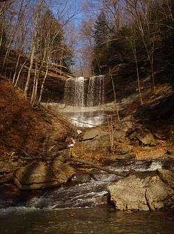
View of Tinker Falls within Labrador Hollow Unique Area | |
 Location of Labrador Hollow Unique Area within New York State | |
| Location | Cortland and Onondaga counties, New York |
| Nearest city | Tully, New York |
| Coordinates | 42°47′10″N 76°02′46″W / 42.786°N 76.046°WCoordinates: 42°47′10″N 76°02′46″W / 42.786°N 76.046°W |
| Area | 1,474 acres (5.97 km2)[1]:8 |
| Established | 1978[1]:12 |
| Governing body | New York State Department of Environmental Conservation |
The Labrador Hollow Unique Area is a 1,474-acre (5.97 km2) conservation area located in Cortland and Onondaga counties, New York, and is the State's first Unique Area. The area is located adjacent to and between Kettlebail State Forest and Morgan Hill State Forest, and is managed by the New York State Department of Environmental Conservation. The area is open to the public and includes Labrador Pond and Tinker Falls.
Physical features
Labrador Hollow sits within a one-half-mile-wide (0.80 km) glacially carved valley with steep walls. The valley's orientation and topography cause it to be shaded for most of the day, leading to cooler conditions and plant life more typical of mountain bogs such as those found in the Adirondacks.[1]:12
Tinker Falls
Tinker Falls[2] (also known as Tinkers Falls) is a waterfall approximately 50 feet (15 m) in height.[3] The falls are formed by a small stream which cut a gorge through shale above a 20-to-30-foot-thick (6.1 to 9.1 m) layer of limestone, which rests atop more shale. As the limestone shelf eroded much slower than the more easily eroded shale below, a waterfall with a recessed amphitheater was formed.[4]
Labrador Pond
Labrador Pond[5] is 102 acres (41 ha) in size,[6] and is shallow throughout, with a maximum depth of four to five feet (1.2 to 1.5 m).[7] The pond supports a variety of warm-water fish species, and contains significant aquatic vegetation.[6] The pond's outflow is Labrador Creek, which flows into the east branch of the Tioughnioga River.[8]
Recreation and facilities

Labrador Hollow Unique Area is open to the public for recreation including hiking, snowshoeing, cross-country skiing, nature viewing, fishing, hunting, and non-motorized boating. A hang glider launch is located on a hillside in the eastern portion of the area.[7][9]
In addition to 4.8 miles (7.7 km) of trails that are maintained within the area, a 2,000-foot (0.38 mi; 0.61 km) handicapped-accessible boardwalk is available within the wetlands at the northern end of Labrador Pond. Additional accessible features include a fishing pier along the pond's western shore, and a trail to view Tinkers Falls from near its base.[9] Trails to reach the recessed amphitheater behind the falls, as well as to reach the top of the falls, were improved in 2014.[3]
Sportfish species in Labrador Pond include chain pickerel, largemouth bass, pumpkinseed, bluegill, yellow perch, common carp, and brown bullhead.[6] Fishing is permitted from a pier constructed on the western shore, or from non-motorized boats that may be hand-launched from the same location. To protect the sensitive shoreline habitat, shore fishing is not permitted.[7]
Prohibited activities within the unique area include camping and the building of fires, although primitive camping is permitted in the adjacent state forest properties.[7][9]
See also
References
- 1 2 3 Hill and Hollow Unit Management Plan (PDF) (Report). NYS Department of Environmental Conservation. January 2013. Retrieved June 4, 2016.
- ↑ "Tinker Falls". Geographic Names Information System. United States Geological Survey. Retrieved June 5, 2016.
- 1 2 Figura, David (July 28, 2014). "Trail access project at Tinker Falls now includes stone stair cases, spectacular view". The Post-Standard. Syracuse, NY. Retrieved June 5, 2016.
- ↑ Brown, Thomas C. (April 13, 1906). "Columbia Field Work in 1905 Intercollegiate Field Courses in Geology". Science. 23 (589): 589. Retrieved June 5, 2016.
- ↑ "Labrador Pond". Geographic Names Information System. United States Geological Survey. Retrieved June 5, 2016.
- 1 2 3 "Labrador Pond". NYS Department of Environmental Conservation. Retrieved June 5, 2016.
- 1 2 3 4 Rybaak, Spider (2003). Fishing Eastern New York. Globe Pequot. p. 307. ISBN 9780762711000. Retrieved June 5, 2016.
- ↑ Conheady, Matt. "Tinkers Falls, Truxton". NYFalls. Retrieved June 5, 2016.
- 1 2 3 "Labrador Hollow Unique Area". NYS Department of Environmental Conservation. Retrieved June 5, 2016.
Offringa, Jane A. (Rowan) 1982. A Natural Resources Inventory of the Labrador Hollow Unique Area", Graduate Thesis in partial fulfillment of Master of Science degree from State University of New York, College of Environmental Science and Forestry at Syracuse University.