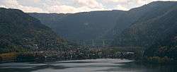
Lac de Nantua
| Lac de Nantua | |
|---|---|
 | |
| Location | Nantua, Ain |
| Coordinates | 46°9′43.62″N 5°35′17.75″E / 46.1621167°N 5.5882639°ECoordinates: 46°9′43.62″N 5°35′17.75″E / 46.1621167°N 5.5882639°E |
| Type | Ice |
| Basin countries | France |
| Max. length | 2.7 km |
| Max. width | 650 m |
| Surface area | 1.41 km² |
| Average depth | 42.9 m |
| Surface elevation | 475 m |
Lac de Nantua (Nantua Lake) is a lake located between Nantua, Montreal-la-Cluse and Port in Ain glacial an expanse of 141 hectares. The lake was made a protected natural site in 1935.
Formation
Nantua Lake is a glacial lake. Its formation is the result of an overflow towards the west a huge orientation North South. The original extent of the glacier lake, once the glaciers disappeared, (the study of terminal glacial moraines) was about two to three times area of 2000 with extensions in the plain in three directions (Nurieux, Saint Martin du Fresne, Montreal). This explains the significant depth (42.9 m) and its configuration in the form of ice gorge east-west areas at risk of flooding towards the plain and Port areas moraines. Its scope was much larger and was marked by two arms of lakes and large marshes to unhealthy important work done in 1856. This work lowered the lake level by more than one meter. The cleared zones were cleaned and sold largely to individuals in 1869 by the mayor of Nantua previously owned these recently discovered areas.