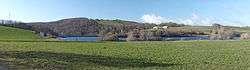
Lac de Saint-Amans
| Lac de Saint-Amans | |
|---|---|
 Lac de Saint-Amans | |
| Location | Aveyron |
| Coordinates | 44°4′16″N 2°45′15″E / 44.07111°N 2.75417°ECoordinates: 44°4′16″N 2°45′15″E / 44.07111°N 2.75417°E |
| Type | reservoir |
| Primary outflows | ruisseau de St-Amans |
| Basin countries | France |
| Surface area | 0.11 km2 (0.042 sq mi) |
| Max. depth | 26 m (85 ft) |
| Surface elevation | 727 m (2,385 ft) |
Lac de Saint-Amans is an artificial lake in Le Truel, Aveyron, France close to Villefranche-de-Panat, and 500m above the Tarn river. At an elevation of 727 m, it has surface area of 0.11 km². It is captured by the Barrage de Saint-Amans. It is a holding reservoir, taking water between the Lac de Villefranche-de-Panat and the hydro-electric power station at Le Pouget power station. [1]
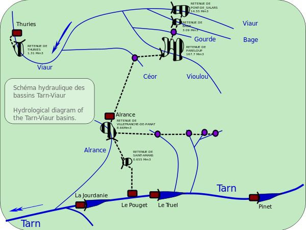
Diagram of the linked rivers, reservoirs, dams, pipelines, pumping stations and power stations.
References
- Notes
- ↑ Pouget (Le) Hydroelectric Power Station France is located at Le Truel, Aveyron, France. Location coordinates are: Latitude= 44.06, Longitude= 2.769. This infrastructure is of TYPE Hydro Power Plant with a design capacity of 572.5 MWe. . It is operated by Electricité de France (EDF). Data obtained from: Licence CC-BY.
This article is issued from Wikipedia - version of the 8/9/2016. The text is available under the Creative Commons Attribution/Share Alike but additional terms may apply for the media files.