Lake Charles Trail
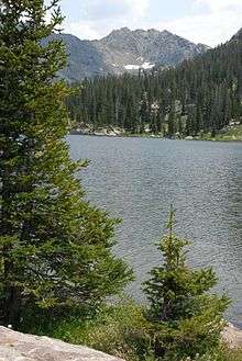
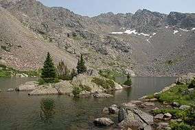
Lake Charles Trail is in the northwestern Sawatch Range, part of the Rocky Mountains in the U.S. state of Colorado. It is located in the Holy Cross Wilderness west of New York Mountain in Eagle County. Lake Charles Trail is south of Interstate 70, near Eagle and Fulford, Colorado. Lake Charles Trailhead can be found by driving eleven miles south from Eagle on Brush Creek Road. At the fork in the road, turn left onto East Brush Creek Road and travel six miles to Yeoman Park Forest Service Campground. Lake Charles is 3.0 miles up the trail at 11,120 feet. The trail continues through forest, past meadows filled with wildflowers in summer, and alongside wetlands filled with short willows. Mystic Island Lake, 11,350 feet, is tucked against steep slopes an hour hike above Lake Charles. Gold Dust Peak, 13,365 feet, overlooks Lake Charles Trail to the north. Fools Peak, 12,947 feet, lies south of Lake Charles, with the cirque of Eagle Peak, 13,043 feet, at the south end of Mystic Island Lake. Hiking Colorado: Holy Cross Wilderness, a hiking guide by Kim Fenske, provides a description of Lake Charles Trail.
References
- ASIN B00DE51D36, Hiking Colorado: Holy Cross Wilderness
- Hiking takes its toll on the backcountry, Vail Daily
Coordinates: 39°27′43″N 106°38′06″W / 39.46194°N 106.63500°W