Lake Disappear
| Lake Disappear | |
|---|---|
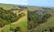
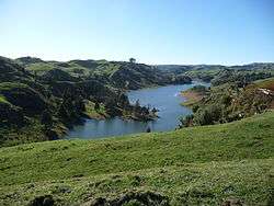 Lake Disappear when full viewed from Kawhia Rd (July 2008) | |
| Location | Waikato District, Waikato Region, North Island |
| Coordinates | 37°55′S 174°55′E / 37.917°S 174.917°ECoordinates: 37°55′S 174°55′E / 37.917°S 174.917°E |
| Lake type | intermittent lake |
| Primary inflows | Pakihi Stream |
| Primary outflows | sinkhole |
| Catchment area | 7 km2 (2.7 sq mi) |
| Basin countries | New Zealand |
| Max. length | 2 km (1.2 mi) |
| Average depth | up to 15 metres |
| Surface elevation | 170 m (560 ft) |

Lake Disappear is an intermittent lake (see also Turlough (lake) and Polje) situated in the North Island of New Zealand, just over 20 km from Raglan, 4 km beyond Bridal Veil waterfall. It has also been described as a solution lake.[1] The south end can be seen from Kawhia Rd and, when the north end is full, it can be seen from the point which is at the end of Plateau Rd on the Pipiwharauroa Way.[2]
Lake formation, volcanism and limestone
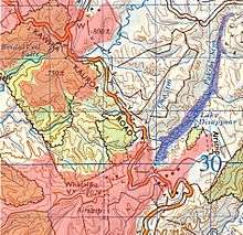
Lake Disappear lies in a valley dammed by a lava flow (similar to the one which also formed Bridal Veil waterfall - see map below) and drained through a limestone sinkhole. The lava flow, which covered the limestone, was part of the Okete Volcanics about 2 million years ago, coming from a vent on Whataipu (see map), just over a kilometre away. Page 43 of the 'Geology of the Raglan-Kawhia Area' says, “Only a few specific areas within the larger catchments are prone to flooding where river flow is restricted, most notably at Lake Disappear (R15/795635 [now on Topo maps BD32 & BE32[3]]) Here, the Pakoka River [should be Pakihi – Pakoka is the next valley with Bridal Veil fall] drains underground through limestone (Elgood Limestone). During times of prolonged heavy rain, water backs up behind the outlet to form a sizable lake over what are normally dry alluvial flats.”[4]
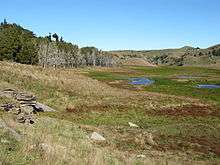
Elgood Limestone (an outcrop is in the photo - see Gallery - to the left) is part of the Glen Massey Formation. The geology guide[4] describes it as, “forming prominent bluffs or surface outcrops displaying solution channels, lapiez, and sinkholes, and is everywhere a light grey, flaggy limestone containing up to 95% CaCO3. Glauconite is common throughout, together with Mesozoic pebbles and greensand near the base”. About its late Whaingaroan (about 27 million years ago) creation, it says, “The change from estuarine, shallow brackish water conditions (Mangakotuku Formation), to fully marine, open sea, aerobic conditions (Glen Massey Formation) is evidenced by near shore accumulation of the bioclastic Elgood Limestone, onlap of the succeeding Dunphail Siltstone, and subsequent deposition of Ahirau Sandstone in an inner to mid shelf environment.”
Biota
Pakihi is a Māori term now commonly used to describe poorly drained, infertile land.[5] Much of the watershed of Lake Disappear was podocarp forest but is now mostly sheep and beef farms, with Te Uku Wind Farm around the source. A survey for the windfarm described the Pakihi, 2 km up from the Lake (site PR2), as having poor to moderate ecological health, indicated by significant growths of long-green filamentous algae. Landcare Research says, “Enrichment of the water with nutrients causes algal blooms, and changes the algal community from a slowgrowing, diverse mixture into one dominated by problem algae like thick filamentous mats”.[6] Inanga, longfin eel, koura (freshwater crayfish), freshwater snails, shrimps and banded kokopu have been found in the stream and Kaoro Climbing galaxias (Galaxias brevipinnis) may be present. A January 2008 survey identified these indicators of stream quality as being present (the numbers on the left are the MCI Score[7] - the higher the score, the more sensitive these macroinvertebrates are to pollution. The words on the right show how common or rare they were in the Pakihi) -
(9) Caddisfly Olinga feredayi[7]
(9) spiny-gilled mayfly[7] Coloburiscus humeralis occasional
(8) mayfly[7] Deleatidium occasional
(7) double-gilled mayfly[7] Zephlebia occasional
(7) caddisfly Rhyacophilidae abundant
(7) dobsonfly Archichauliodes diversus[7] common
(6) riffle beetle Elmidae[8] 6 occasional
(5) stony-cased caddisfly Pycnocentrodes[9] common
(5) Crustacea Paratya curvirostris occasional
(4) mud snail Potamopyrgus antipodarum common
(3) sand fly Austrosimulium occasional
(3) New Zealand freshwater mussel Hyridella rare [10]
See also
Gallery

References
- ↑ J D Green, D J Lowe (1992). Landforms of New Zealand (PDF). Longrnan Paul, Auckland. p. 135.
- ↑ "Pipiwharauroa Walking and Biking Trail | The Raglan Website". Raglan.gen.nz. 2011-08-27. Retrieved 2012-12-26.
- ↑ "Map Chooser | Land Information New Zealand (LINZ) - Toitū te whenua". LINZ. 2010-10-03. Retrieved 2012-12-18.
- 1 2 Geology of the Raglan-Kawhia Area: Institute of Geological & Nuclear Sciences (N.Z.), Barry Clayton Waterhouse, P. J. White 1994 ISBN 0-478-08837-X
- ↑ "Pakihi - Rural language - Te Ara Encyclopedia of New Zealand". Teara.govt.nz. 2009-03-01. Retrieved 2012-12-26.
- ↑ http://www.landcareresearch.co.nz/__data/assets/pdf_file/0018/41418/chp_8_nutrients.pdf
- 1 2 3 4 5 6 "Underwater Life - Macroinvertibrates". Waitakere.govt.nz. Retrieved 2012-12-26.
- ↑ "Riffle beetles". Landcare Research. 2012-09-25. Retrieved 2012-12-26.
- ↑
- ↑ http://www.wel.co.nz/files/Wind%20Generation/Kessels%20Feb%2008.PDF