Lake Lila
| Lake Lila | |
|---|---|
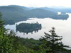 Canada Island, Lake Lila, from Mount Frederica | |
| Location | Adirondacks, Hamilton County, New York, United States |
| Coordinates | 44°00′08″N 074°45′20″W / 44.00222°N 74.75556°WCoordinates: 44°00′08″N 074°45′20″W / 44.00222°N 74.75556°W |
| Primary inflows | Shingle Shanty Brook |
| Primary outflows | Beaver River |
| Basin countries | United States |
| Max. length | 2.6 mi (4.2 km) |
| Max. width | 2 mi (3.2 km) |
| Surface area | 1,400-acre (5.7 km2) |
| Surface elevation | 1,720 ft (520 m) |
| Islands | 6 |
| Settlements | none |
Lake Lila is a 1,400 acre (5.6 km²) Lake in the William C. Whitney Wilderness Area, in the town of Long Lake, in the west-central portion of the Adirondack Park.
Lake Lila is the largest lake in the Adirondack Park whose shoreline is entirely state-owned; it is the twenty-second largest body of water in the park. The southeastern portion of Lake Lila is an extensive wetland drained by the Shingle Shanty Brook, which feeds the lake; the lake is drained by the Beaver River. The lake is bordered by 2,220-foot (680 m) Mount Frederica.
There are 24 primitive campsites, 18 of which are accessible only by boat. Boats must be hand-launched, and motors are not permitted; there is a 0.3-mile (0.48 km) carry from the parking lot to the lake.
History
Lake Lila was originally called Smith Lake. William Seward Webb assembled a 115,000-acre (470 km2) preserve, called Nehasane Park, in the process of creating the Mohawk and Malone Railway. Webb built a Great Camp, Forest Lodge, on the western shore of Smith Lake, which he renamed for his wife, Lila Osgood Vanderbilt Webb, the daughter of William H. Vanderbilt.
In 1979, New York State acquired the 7,200 acres (29 km2) of Nehasane Park surrounding Lake Lila; Forest Lodge was razed by the state at the request of the Webb family as part of the acquisition process. The railway station that formerly served the lodge still stands. The area was originally known as Lake Lila Primitive Area, before it was made a part of the William C. Whitney Wilderness Area in 1997. The railroad right-of-way is now the Remsen-Lake Placid Travel Corridor.