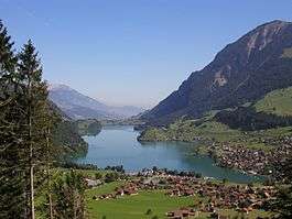
Lake Lungern
| Lake Lungern Lungerersee Lungernsee | |
|---|---|
 | |
 Map | |
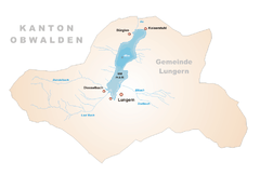
| Location | Obwalden |
| Coordinates | 46°48′9″N 8°9′48″E / 46.80250°N 8.16333°ECoordinates: 46°48′9″N 8°9′48″E / 46.80250°N 8.16333°E |
| Primary inflows | Lauibach, Eibach |
| Primary outflows | Sarner Aa |
| Basin countries | Switzerland |
| Max. length | 2 km |
| Max. width | 200 -800 m |
| Surface area | 2.01 km² |
| Max. depth | 68 m |
| Surface elevation | 688 m |
| Settlements | Lungern |
Lake Lungern (German: Lungerersee, also spelled Lungernsee or Lungerensee) is a natural lake in Obwalden, Switzerland which is named after the town Lungern on its shore. The lake is drained by the Sarner Aa river, which flows through the Sarnersee and into Lake Lucerne.[1]
The lake was originally much larger, and covered a large part of the valley it is situated in. Starting in 1836, its level was lowered by 36 metres through an artificial drainage tunnel of 380 m length.[2] It is used as a reservoir.
External links
- Edy von Wyl: Lungernsee in German, French and Italian in the online Historical Dictionary of Switzerland.
 Media related to Lungerersee at Wikimedia Commons
References
- ↑ map.geo.admin.ch (Map). Swiss Confederation. Retrieved 2013-01-05.
- ↑ Brockhaus' Konversations-Lexikon. 14th ed., Leipzig, Berlin and Vienna 1894; Vol. 11, p. 385
This article is issued from Wikipedia - version of the 11/11/2016. The text is available under the Creative Commons Attribution/Share Alike but additional terms may apply for the media files.