Lake Maxinkuckee
| Lake Maxinkuckee | |
|---|---|
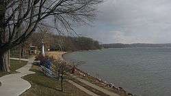 Beach at Culver | |
| Location | Marshall County, Indiana, near Culver |
| Coordinates | 41°12′21″N 086°25′08″W / 41.20583°N 86.41889°WCoordinates: 41°12′21″N 086°25′08″W / 41.20583°N 86.41889°W |
| Basin countries | United States |
| Surface area | 1,864 acres (8 km2) |
| Average depth | 24 ft (7.3 m) |
| Max. depth | 88 ft (27 m) |
| Surface elevation | 732 feet (223 m)[1] |
Lake Maxinkuckee is the second largest natural lake in the U.S. state of Indiana, covering 1,864 acres (8 km2). It is located near the town of Culver, Indiana, in southwestern Marshall County. Lake Maxinkuckee has a maximum depth of 88 feet (27 m) and an average depth of 24 feet (7 m). Local residents and visitors practice ice fishing on the lake.
The first inhabitants of the lake area were Mound Builders, most likely the Potawatomi or Miami. Several mounds were built on the banks of the lake, the largest being "Pare Mound," thought to be used as a point of reference for the natives. The first white settlers arrived in 1836. Henry Harrison Culver, for whom the town is now named, founded the Culver Military Academy in 1894.
The word Maxinkuckee is derived from the Potawatomi word Mog-sin-ke-ki, which means "big stone country".[2]
References
- ↑ U.S. Geological Survey Geographic Names Information System: Lake Maxinkuckee
- ↑ Baker, Ronald L. (October 1995). From Needmore to Prosperity: Hoosier Place Names in Folklore and History. Indiana University Press. p. 213. ISBN 978-0-253-32866-3.
...Mog-sin-kee-ki, "Big Stone Country."
External links
- Historical Lake Maxinkuckee information and genealogical records
- - Information on Lake Maxinkuckee
- "Fates Worse Than Death" by Kurt Vonnegut - he writes about Lake Maxinkuckee