Lake Rotoma
| Lake Rotoma | |
|---|---|
 | |
| Location | Rotorua District, Bay of Plenty Region, North Island |
| Coordinates | 38°02′51″S 176°35′16″E / 38.0476°S 176.5878°ECoordinates: 38°02′51″S 176°35′16″E / 38.0476°S 176.5878°E |
| Lake type | Crater lake |
| Basin countries | New Zealand |
| Max. length | 5.2 km (3.2 mi)[1] |
| Max. width | 4.7 km (2.9 mi)[1] |
| Surface area | 11.2 km2 (4.3 sq mi)[1] |
| Average depth | 38.6 m (127 ft)[1] |
| Max. depth | 83 m (272 ft)[1] |
| Surface elevation | 316 m (1,037 ft)[1] |
| Islands | 1 sunken island |
| References | [1] |
Lake Rotoma is the fourth largest lake of the 11 lakes in the Rotorua Lakes district, or the Hot Lakes district as it was known in the early decades of the 20th century. The Rotorua lakes are located in New Zealand's North Island in the Bay of Plenty Region. Lake Rotoma is the easternmost in the chain of three lakes to the northeast of Lake Rotorua The other two are Lake Rotoiti and Lake Rotoehu. Rotoma is located halfway between the city of Rotorua and town of Whakatane.
Lake Rotoma has a high water quality with visibility up to around 13 metres deep. The lake has a maximum depth of 83 metres in the northern part and 73.5 metres in the southern part.
Geography
Lake Rotoma was formed within the Rotoma caldera when lava flows from a large crater explosion blocked its outlet 9,500 years ago. The hills fringing the south and east of the lake are made up of Rhyolite from Haroharo and Tarawera, and this has meant that Lake Rotoma has no surface outlets. However, the presence of springs has suggested an underground discharge of lake waters. The water level of Rotoma reaches an excessive high or low level every 10–15 years. In times of extreme low levels, the sunken island "Motutara" in the lake may be exposed.
History
Road
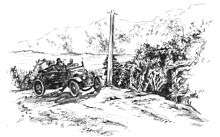
Before the road around Lake Rotoma was constructed, there were several Māori trails over the Rotoma hill which could be used to get between Rotorua and the Eastern Bay of Plenty by foot, but these trails were too narrow and uneven to be used by horses. Travellers from Rotorua could only get as far as Tikitere on the rough track. In May 1895 work commenced on the Tikitere to Rotoma road. By July, there were three road gangs working on different sections of the road, and work began over the difficult section over the Rotoma hill in the summer of 1895–1896. A proper road was also constructed from Te Ngae in Rotorua through to Tikitere.
Once the road was completed, horse-drawn traffic commenced and public coaching services began. The first such service was started in 1907 by the R.M. Company, who ran a service twice a week from Rotorua to Opotiki carrying mail and up to three passengers. In 1910 the R.M. Company upgraded to a large coach drawn by five horses which could hold 10 passengers. In 1916 Colletts of Rotorua started the first regular motor car service, using Cadillac service cars. The average travel time from Rotorua to Whakatane was 5 hours, but like the horse-drawn coaches, the service cars could take up to 9 hours to travel this distance depending on the driving conditions. The road surface gradually improved, decreasing the travel time to 3 hours by the late 1920s.[2] Today, this journey takes just one hour and 20 minutes.
In 1947, 60 men were employed on the construction of the Rotorua to Whakatane highway, as increases in traffic had caused problems on the road which was barely 12 feet wide. In the winter of 1956 the lake level of Rotoma rose very high, causing the road to be shifted to higher ground. More serious flooding occurred in 1962, and the famous "cheese cutting" landmark was destroyed and used to build up the road. The cheese cutting was a large wedge shaped rock formed during road construction in 1895–1896 when the road gangs cut the road through a hill with picks and shovels and left a portion of the hill standing.[3]
Establishments

Various establishments have come and gone at Rotoma, and most were set up to service the passing traveller's desire for rest stops, refreshments and accommodation.
Past establishments
- "Rotoma Tearooms and Post Office", later renamed "The Kettle Store and Tearooms", then "The Kettle Store and Garage".
- "T & K Service Station"
- "Stillwater Lodge & Motel"
- "Rotoma Accommodation House"
- "El Toreador Dine and Dance"
- "Atkinson's Fishing Lodge", later renamed "Merge Lodge"
- "Rotoma Traders"
In 1912 it could take up to 9 hours to cover the distance between Rotorua and Whakatane, and changing stations for the horses had been set up every 14 miles from Rotorua. The changing station at the west end of Rotoma became a popular rest stop. John Baker ran a post office and tearooms here, and built up a reputation for his corned beef. Mr. Baker offered the traveller a choice of corned beef with potatoes and cabbage or corned beef sandwiches.[4]
The Pilbrow family arrived in Rotoma in 1948 after purchasing the Rotoma Tearooms and Post Office. They expanded the business to include a general store, and renamed it The Kettle Store and Tearooms. They then built a garage for motor repairs, and the business became The Kettle Store and Garage. Petrol pumps were later installed by the Pilbrow family to create T & K Filling Station. There was an extremely high level of rainfall in 1961 which caused serious flooding problems, and the business was badly affected. The floodwater raised the petrol tanks out of the ground and the road had to be built up to act as a stop-bank. A pump was in action 24 hours a day for weeks to prevent the water from completely flooding the premises.[5] The Pilbrow family also created Oxford Road.
The original homestead which became known as Atkinson's Fishing Lodge was built early in the 1900s by Mr and Mrs C. Atkinson who farmed near the lake and had an orchard on the opposite side of the road. The homestead was turned into a lodge which became very popular with fishermen. The lodge was renamed Merge Lodge by Geoff and Roy Warwick, formerly of Kawerau, who took over ownership in 1960. The lodge had six bedrooms, a billiard room, two kitchens, two lounges, and a store out the front.[6] There is now a caravan park at the site of Merge Lodge.
Current establishments
- "Rotoma Auto Repair" at the former site of the Kettle Tearooms
- "Art Gecko", art gallery and picture framing business at the former site of the Kettle Tearooms
- Lakeside caravan sites at the location of Merge Lodge
- "Rotoma Trading Post", petrol station and general store located in front of the former site of Merge Lodge
- "Rotoma Roadhouse Cafe and Takeaways" in front of the former site of Merge Lodge
- "Rotoma and Rotoehu Community Hall"
- "Rotoma Holiday Park"
- Lake Rotoma School
- Rotoma Christian Fellowship
"Suicide Beach"
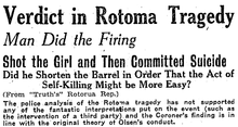
The bay at the foot of the Rotoma hill where Manawahe Road commences had the nickname "Suicide Beach" in the past due to the occurrence of a murder-suicide there in May 1925.[7] The real story was lost over time, with the majority of Rotoma local residents holding the belief that it had been a young honeymoon couple who committed suicide there together. However, in actuality it was a 38-year-old man and a 14-year-old girl; understood to have been romantically attached. The man, Carl Olsen, had told the girl's father of his love for her. In an attempt to separate the pair, the disapproving parents sent the girl, Molly Moors, to live with an aunt in Hastings. Without her aunts knowledge, Olsen picked Molly up in his car and it was assumed they were on their way to Hamilton when they met death at the shores of Rotoma. The event was well covered by newspapers of the time and was referred to as the "Rotoma Tragedy". Olsen and Moors are buried next to each other in the Rotorua Cemetery, and their graves were probably originally marked with wooden crosses.[8] The original crosses disintegrated over time leaving the two graves unmarked for many years before being remarked with new matching wooden crosses in May 2011.
Sunken island
Four buoys in the southern portion of Lake Rotoma mark the location of Motutara, the sunken island, which sits just under the lakes surface. Occasionally the lake level drops low enough to expose the top of the island. There was once a Māori village on the island, and according to the legend, an old Tohunga resided there amongst the other inhabitants. His name was Te Rarau-mai-Waho, and he was very powerful and dangerous. The cloud the old Tohunga cast over the island was lifted only on the occasions where he went to visit some of his relations in Kawerau and around Putauaki, Mount Edgecumbe. One night he returned from such a visit and called out to the people of the island from the lake's edge by Matahi lagoon, ordering them to send him a canoe. Nobody responded to his demands, and in his anger the Tohunga put a curse on the island and its inhabitants. The people of the island heard the angry Tohunga's terrible screams, but did not realise the horrible retribution he would take. The curse caused the island to slowly sink, and by morning it was completely underwater; the only signs of the village being bodies and pieces of wreckage floating on the surface of the lake. Some people had escaped by swimming to the shore of the lake, and these people eventually settled in the South Island.[9] The Waikato Underwater Club has examined Motutara. Two platforms or terraces were found, and some hāngi stones were found at the peak. It has been suggested that if the Pā had been palisaded it may have still been there today.[10]
Settlement
The 2006 census revealed that 1,863 people usually live in the wider Rotoma area; 0.7 percent of Bay of Plenty Region's population. However, the lakeside portion of the Rotoma area has a much smaller permanent population, as many of the dwellings are used only as holiday homes. The most common ethnic group in the wider Rotoma area is Māori, at 49.9% of the population. This compares to a 27.5% Maori population for the Bay of Plenty Region as a whole.[11]
Early settlement
The early road construction crews commented on the lack of Maori settlement in Rotoma and in the neighbouring Lake Rotoehu. However, fortified pā sites, food pits, cultivation areas and burial sites have been discovered around Rotomas shorelines and the surrounding hills . The tribe Ngāti Tūwharetoa may not have lived permanently at Rotoma but at least took out a temporary camping existence there to take advantage of the hunting and fishing opportunities on offer. Later, Ngati Tuahuriri, a sub-tribe of Ngati Pikiao took up residence at Rotoma. The Rotoiti natives credit the native and European wars as the cause of the dispersion of this Maori population, and they had left Lake Rotoma by the time the road construction began in 1895.
A census for the years 1874 to 1891 shows nil for Rotoma. In 1896 a census shows a population of 33, understood to be the occupants of the camp set up for the road workers and their families at the east end of Oneroa beach by the lagoon.
Oxford Road
In 1948, Mr and Mrs T.H. Pilbrow and their children arrived at Lake Rotoma from Oxford in Canterbury. They had purchased the Rotoma Tearooms and Post Office, which was situated on 25 acres of land. In a district of predominantly leasehold land, the Pilbrows realised the value of their 25 acres of freehold land and decided to subdivide it in 1950. Sixty-three sections were surveyed, the majority each a quarter acre, and four of these were taken by the Rotorua County Council for a reserve. Seventeen sections were along the main road, but a new road was required to access the sections to the rear. The Pilbrows named the new road "Oxford Road" as a reminder of their hometown.[12]
Lake Rotoma School
The first school was opened on 2 February 1928 in the old tearooms building with Mr. E.G. Sutherland teaching the 8 students. Mr Sutherland stated that it was "probably the worst building in New Zealand. However, when the weather was too bad we just declared a holiday – and nobody seemed to worry" A new school was built and opened in its present location on Soda Springs Road on 25 May 1936 with 29 students.[13] The roll fluctuated due to numerous residents living at Rotoma on a temporary basis, but was The mills in the area, Tunnicliffe's Mill and Rendall's Mill, helped establish a more stable population at Rotoma and caused further overcrowding at the school. In 1973 the roll reached 55 and there were appalling working conditions for staff and children. On 14 August 1973 the majority of parents kept their children at home as a protest against the lack of action to improve standards. There was widespread media coverage and in October the Minister of Education ordered that a new school be built, and it was opened on 16 November 1974. From 1948, Mr Tam Pilbrow operated the first bus service to the school, using a Hillman car.[14] In 1952 the service was taken over by George Graham, and Mr. Pilbrow's son Ken, who operated a Bradford van from the Kettle Store.[15] Mr Gavin Wyllie bought the Kettle Store and Garage, and in 1958 he commenced transporting children to the school in his V.W combie van, but when Rendall's Mill closed at the end of that same year, there were not enough children for him to continue the service.
References
| Wikimedia Commons has media related to Lake Rotoma. |
- 1 2 3 4 5 6 7 Lowe, D.J., Green, J.D. (1987). Viner, A.B., ed. Inland waters of New Zealand. Wellington: DSIR Science Information Publishing Centre. pp. 471–474. ISBN 0-477-06799-9.
- ↑ Moore, K.W. (1998). "Lake Rotoma". Historical Review: Bay of Plenty Journal of History. Volume 46, Number 2, p.70
- ↑ Moore, K.W. (1998). "Lake Rotoma". Historical Review: Bay of Plenty Journal of History. Volume 46, Number 2, p.73
- ↑ Moore, K.W. (1998). "Lake Rotoma". Historical Review: Bay of Plenty Journal of History. Volume 46, Number 2, p. 70
- ↑ Chapman, V.J. (1978). Lake Rotoma School 50th Jubilee 1928–1978 Ian Bryce Ltd, pg. 3
- ↑ Moore, K.W. (1998). "Lake Rotoma". Historical Review: Bay of Plenty Journal of History. Volume 46, Number 2, p. 72
- ↑ Papers Past "Tragedy by Lonely Lake" NZ Truth, 9 May 1925, accessed 20 March 2011.
- ↑ Rotorua District Council Cemetery Search Accessed 25 March 2011.
- ↑ Chapman, V.J. (1978). Lake Rotoma School 50th Jubilee 1928–1978 Ian Bryce Ltd, pg. 8
- ↑ Moore, K.W. (1998). "Lake Rotoma". Historical Review: Bay of Plenty Journal of History. Volume 46, Number 2, p. 62
- ↑ Statistics New Zealand New Zealand Census 2006 data, Accessed 20 June 2011
- ↑ Moore, K.W. (1998). "Lake Rotoma". Historical Review: Bay of Plenty Journal of History. Volume 46, Number 2, p. 76-77
- ↑ Moore, K.W. (1998). "Lake Rotoma". Historical Review: Bay of Plenty Journal of History. Volume 46, Number 2, p. 74
- ↑ Moore, K.W. (1998). "Lake Rotoma". Historical Review: Bay of Plenty Journal of History. Volume 46, Number 2, p. 75
- ↑ Chapman, V.J. (1978). Lake Rotoma School 50th Jubilee 1928–1978 Ian Bryce Ltd, pg. 11