Landmannalaugar
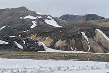
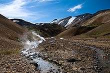
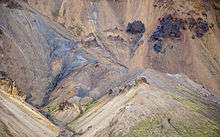
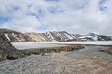
Landmannalaugar (Icelandic pronunciation: [ˈlan̥tmanːaˌløiɣar̥]) is a place in the Fjallabak Nature Reserve [1] in the Highlands of Iceland. It is at the edge of Laugahraun lava field, which was formed in an eruption around the year 1477.[2] It is known for its natural geothermal hot springs and surrounding landscape.
Landmannalaugar is the northern end of the Laugavegur hiking trail and a popular destination for tourists traveling in Iceland. The Iceland Touring Association operates a mountain hut with sleeping bag accommodation for 75 people and a public toilet with showers.[3] During the tourist high season there is also a small shop there that sells coffee and basic groceries, a horse tour agency. ICE-SAR highland patrol in Fjallabak operates from here. Several bus companies have regular trips to and from Landmannalaugar during the tourist season.
Routes
Four routes lead to Landmannalaugar and one of them is accessible by regular car, though the road is rough (stones the size of fists are not uncommon as well as washing-board style sections of the road). Rented cars are not allowed on either road as F roads are usually only intended for 4WD vehicles. The easiest route to Landmannalaugar is to take either Road 30 from the main road and change into Road 32, cross the Sultartangi hydro-electric dam, going onto F26, then F208 and just before arriving in Landmannalaugar, making a right turn to F224. Road 26 can also be accessed directly from Rd. 1 just before arriving in the small village of Hella, crossing through typical Icelandic farmland landscape. There are also roads leading to Landmannalaugar from the east via Eldgjá or the north via Sprengisandur, both 4WD roads only.
Activities
Hiking
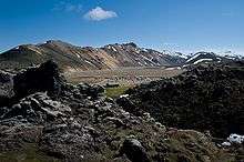
Landmannalaugar is famous for its hiking trails. The most popular routes include the 2 hour hike through the Laugahraun lava field to Mt. Brennisteinsalda ("Sulphur Wave"), the 1 hour hike up Mt. Bláhnjúkur ("Blue Peak") and the 4 hour hike to Ljótipollur crater lake ("Ugly Puddle"). Landmannalaugar can also be the starting point of several longer hiking trails, such as the 3-4 day Hellismannaleið route at the base of the Hekla volcano and Sprengisandur route for hikers prepared to travel through the volcanic desert.
Landmannalaugar is the usual starting point for a four-day-long hiking trail aptly called Laugavegur, as the main shopping street in Reykjavík city center is called the same and is referred to the herds of people that walk the trail every day. The name actually means "The Landmannalaugar Trail", "Laugar" being a shortened version for "Landmannalaugar". The usual four day trail ends in Þórsmörk, but one or two days can be added, trekking then all the way to Skógar nearly at the coast via Fimmvörðuháls between the two glaciers Eyjafjallajökull and Mýrdalsjökull.
The huts on the Laugavegur and Fimmvörðuháls trails are (from north to south):
- Landmannalaugar
- Hrafntinnusker
- Álftavatn
- Hvanngil
- Botnar
- Þórsmörk
- Fimmvörðuháls
Other activities
Icelandic horse riding has been available in the area each summer, although not summer of 2013. The horse riding trips visit places which can often be difficult to access on foot and not accessible by car as there are no official roads, as an example into Jökulgil (Glacier Valley). Arctic char fishing takes place in Landmannalaugar and nearby lakes. From late June and through the summer, a shop called the Mountain Mall is operated inside a green American school bus from the 70s which stocks groceries and other things useful for camping. The buses are still operating and are driven there in June and taken back at the end of September when the season finishes. In the winter the hut is used as a base for cross-country skiing [4]
References
- ↑ "Auglýsing um friðland að Fjallabaki". Stjórnartíðindi B, nr. 354/1979. August 13. 1979. Retrieved on August 21. 2014. (In Icelandic)
- ↑ Sigurður Steinþórsson. "Í hvaða gosi myndaðist hraunið hjá Landmannalaugum og hvaða ár?". The Icelandic Web of Science July 4. 2008. Retrieved on 21 August 2014. (In Icelandic)
- ↑ "LANDMANNALAUGAR HUT" Retrieved on 21 August 2014.
- ↑ "Landmannalaugar Cross Country Skiing Tour | Icelandic Mountain Guides". Mountainguides.is. Retrieved 2016-08-21.
External links
| Wikivoyage has a travel guide for Landmannalaugar. |
| Wikimedia Commons has media related to Landmannalaugar. |
Information:
- The official Landmannalaugar site for tours & activities
- The official Landmannalaugar information site
- Ferðafélag Íslands; for booking huts on the Laugavegur hiking trail
- Description, map view, and track download of the Laugavegur and Fimmvörðuháls trails (south to north)
Photos:
- Mountains near Landmannalaugar
- Coming down laugarvegur from Hrafntinnusker
- Laugarvegur, in the foreground Brennisteinsalda, right-hand side in the middle ground, Bláhnjúkur
- The campground of Landmannalaugar
- Panoramic virtual tour of Landmannalaugar
Coordinates: 63°58′59″N 19°04′01″W / 63.983°N 19.067°W