Larsen Harbour
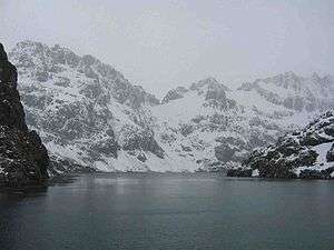
Larsen Harbour is a narrow 2.6 miles (4.2 km) long inlet of indenting volcanic rocks and sheeted dykes known as the Larsen Harbour Formation.[1] It is a branch of Drygalski Fjord, entered 2.5 miles (4 km) west-northwest of Nattriss Head, at the southeast end of South Georgia. It was charted by the German Antarctic Expedition, 1911–12, under Filchner, who named it for Captain Carl Anton Larsen a Norwegian Antarctic Explorer, who made significant contributions to the exploration of Antarctica. The most significant being the first discovery of fossils, for which he received the Back Grant from the Royal Geographical Society.[2] Larsen is also considered the founder of the Antarctic whaling industry and the settlement at Grytviken, South Georgia.[3][4][5]
The peaks and mountain crests surrounding the almost land-locked harbour was described by Sir Ernest Shackleton's photographer Frank Hurley as "most beautiful and exceeding all in grandeur even that of Milford Sound ".[6]
The Niall Rankin expedition aboard the Albatross, spent some time here as they studied the Weddell seal colony before going on to Esbensen Bay.[7]
The area is rat-free, allowing species such as the South Georgia pipit, and burrowing petrels and prions to thrive. Mountains descend steeply into the sea here, and various glaciers calve into the sea.[8][9]
References
Books
- Headland, Robert (1984). The Island of South Georgia. New York: Cambridge University Press. ISBN 0-521-25274-1.
- Mills, William James (2003). Exploring Polar Frontiers A Historical Encyclopedia. ABC-CLIO. pp. 373–374. ISBN 1-57607-422-6.
- Murphy, Shane (2001). Shackleton's photographer [CD Rom] : Photographs of scenes and diary of incidents in connection with happenings to the Weddell Sea Party, 12th October, 1914 - 16th October, 1917. Scottsdale, AZ: Shane Murphy. ISBN 0-9703148-2-5.
- Rabassa, Jorge; Borla, Maria Laura (2006-11-21). Antarctic Peninsula & Tierra del Fuego. Taylor and Francis. p. 40. ISBN 978-0-415-41379-4.
- Stonehouse, Dr Bernard, ed. (2002). Encyclopedia of Antarctica and the Southern Oceans. Toronto: Wiley. ISBN 0-471-98665-8.
- Wheeler, Tony (2004). The Falklands & South Georgia Island. Footscray, Vic.: Lonely Planet Publications. p. 160. ISBN 1-74059-643-9.
Journals
- Bell, C.M.; Mair, B.F.; Storey, B.C. "The pre-Cretaceous Larsen Harbour Formation of southern Soulh Georgia". British Antarctic Survey.
- MAIR, B. F. "The Larsen Harbour Formation and associated intrusive rocks of southern South Georgia". Bulletin - British Antarctic Survey. British Antarctic Survey, Natural Environment Research Council, Cambridge. 52 (983): 87–107. ISSN 0007-0262.
Further reading
- Carr, Tim; Carr, Pauline (1998). Antarctic oasis : Under the spell of South Georgia. New York: W.W. Norton. ISBN 0-393-04605-2. Retrieved 25 October 2009.
Footnotes
- ↑ Bell, C.M.; Mair, B.F.; Storey, B.C. "The pre-Cretaceous Larsen Harbour Formation of southern South Georgia" (PDF). British Antarctic Survey. Retrieved 25 October 2009.
- ↑ Rabassa, Jorge; Borla, Maria Laura (2006-11-21). Antarctic Peninsula & Tierra del Fuego. Taylor and Francis. p. 40. ISBN 978-0-415-41379-4.
- ↑ Mills, William James (2003). Exploring Polar Frontiers A Historical Encyclopedia. ABC-CLIO. pp. 373–374. ISBN 1-57607-422-6.
- ↑ Dr Bernard Stonehouse, ed. (2002). Encyclopedia of Antarctica and the Southern Oceans. Toronto: Wiley. ISBN 0-471-98665-8. Retrieved 25 October 2009.
- ↑ "Larsen Harbor". Geographic Names Information System. United States Geological Survey. Retrieved 3 June 2013.
- ↑ Murphy, Shane (2001). Shackleton's photographer [CD Rom] : Photographs of scenes and diary of incidents in connection with happenings to the Weddell Sea Party, 12th October, 1914 - 16th October, 1917. Scottsdale, AZ: Shane Murphy. ISBN 0-9703148-2-5. Retrieved 25 October 2009.
- ↑ Headland, Robert (1984). The Island of South Georgia. New York: Cambridge University Press. ISBN 0-521-25274-1. Retrieved 25 October 2009.
- ↑ Wheeler, Tony (2004). The Falklands & South Georgia Island. Footscray, Vic.: Lonely Planet Publications. p. 160. ISBN 1-74059-643-9. Retrieved 25 October 2009.
- ↑ MAIR, B. F. "The Larsen Harbour Formation and associated intrusive rocks of southern South Georgia". Bulletin - British Antarctic Survey. British Antarctic Survey, Natural Environment Research Council, Cambridge. 52 (983): 87–107. ISSN 0007-0262.
Coordinates: 54°50′S 36°1′W / 54.833°S 36.017°W
![]() This article incorporates public domain material from the United States Geological Survey document "Larsen Harbor" (content from the Geographic Names Information System).
This article incorporates public domain material from the United States Geological Survey document "Larsen Harbor" (content from the Geographic Names Information System).
Capital: King Edward Point (Grytviken) | |
| General | |
| Settlements / Whaling stations | |
| South Georgia islands | |
| South Sandwich islands | |
| Landmarks |
|