Las Palmas Cove
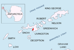
Las Palmas Cove is an 1.97 km wide embayment indenting for 500 m the northwest coast of Hurd Peninsula on Livingston Island in the South Shetland Islands, Antarctica. It is part of South Bay, Livingston Island entered between Henry Bluff and Salisbury Bluff. The area was visited by early 19th century sealers operating from nearby Johnsons Dock. It also where the Las Palmas Glacier terminates.
The feature was mapped and named in 1991 by the Spanish Antarctic Expedition after the Antarctic supply ship Las Palmas, Spanish Navy.
Location
The cove's midpoint is located at 62°40′57.2″S 60°25′02.1″W / 62.682556°S 60.417250°W which is 4.84 km south-southwest of Hespérides Point and 4.32 km north by east of Miers Bluff (British mapping in and 1968, detailed Spanish mapping in 1991, and Bulgarian mapping in 2005 and 2009).
Maps
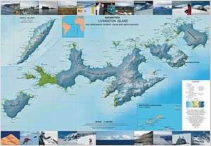
- Isla Livingston: Península Hurd. Mapa topográfico de escala 1:25 000. Madrid: Servicio Geográfico del Ejército, 1991.
- L.L. Ivanov et al. Antarctica: Livingston Island and Greenwich Island, South Shetland Islands. Scale 1:100000 topographic map. Sofia: Antarctic Place-names Commission of Bulgaria, 2005.
- L.L. Ivanov. Antarctica: Livingston Island and Greenwich, Robert, Snow and Smith Islands. Scale 1:120000 topographic map. Troyan: Manfred Wörner Foundation, 2009. ISBN 978-954-92032-6-4