Latifpur
| Latifpur | |
|---|---|
|
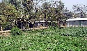
Latifpur village along with Chhadu Ullah Munsi Road at the center | |
 Latifpur Location in Bangladesh | |
| Coordinates: 22°22′39.8″N 91°45′50″E / 22.377722°N 91.76389°ECoordinates: 22°22′39.8″N 91°45′50″E / 22.377722°N 91.76389°E | |
| Country |
|
| Division | Chittagong Division |
| District | Chittagong District |
| Population (2011) | |
| • Total | 9,901[1] |
| Time zone | Bangladesh Time (UTC+6) |
Latifpur (Bengali: লতিফপুর Lotifpur) is a village in Chittagong District in the Chittagong Division of southern Bangladesh. It is situated in Salimpur Union, which until 2013 was in Sitakunda Upazila.[1] In January 2013, four new thanas were created in Chittagong District.[2] Latifpur is now in Akbarshah Thana. Salimpur is situated at the north, Colonelhat at the south and Bay of Bengal situated at the west. Two port connecting road highway and railway passes through Latifpur. High school, primary school sets of kindergarten are situated in this area.
References
- 1 2 "Population Census 2011: Chittagong Table C-01" (PDF). Bangladesh Bureau of Statistics. Retrieved 11 July 2014.
- ↑ "Gazipur to be city corporation". The Daily Star. Bangladesh. UNB. 7 January 2013. Archived from the original on 8 January 2013. Retrieved 7 January 2016.
This article is issued from Wikipedia - version of the 12/3/2016. The text is available under the Creative Commons Attribution/Share Alike but additional terms may apply for the media files.