Laupen Castle
_p419_LAUPEN.jpg)

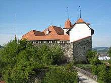

Laupen Castle (German: Schloss Laupen) is a castle in the municipality of Laupen of the Canton of Bern in Switzerland. It is a Swiss heritage site of national significance.[1]
History
Laupen Castle was built in the 10th-13th centuries as part of a line of imperial castles along the Sense and Saane rivers, which meet at Laupen. The castle was built with a keep, main tower, and ring wall on a sandstone spur above the Sense river.
Under the Second Kingdom of Burgundy, the castle was a residence of the kings. It then passed to the Dukes of Zähringen under whom it became the residence of a count. After the extinction of the Zähringen family it eventually was acquired by the Counts of Kyburg in 1253. The Kyburg main line died out in 1263 and the castle and surrounding lands became the center of a power struggle between the Habsburgs (the inheritors of the Kyburg lands) and the Counts of Savoy. The victorious Habsburgs appointed a castellan for Laupen Castle in 1269. The castellan was replaced by an imperial governor after 1300. In 1310 Emperor Henry VII pledged the castle and lands as collateral for a loan. In 1324, Bern acquired the pledged castle and lands. When the Emperor was unable to repay the loan, Laupen became the first bailiwick of Bern.[2]
After Laupen became part of the Canton of Bern, the castle was the Bernese administrative headquarters. The castle stairway was expanded in 1580-99. The administrative offices in the castle were expanded in 1648-50 and it was totally renovated in 1983-88. During the 15th and 16th centuries, the bailiwick of Laupen expanded several times.[2] Until 1798 the castle was the official residence of bailiff of Laupen.
See also
References
- ↑ "Kantonsliste A-Objekte". KGS Inventar (in German). Federal Office of Civil Protection. 2009. Retrieved 25 April 2011.
- 1 2 Laupen in German, French and Italian in the online Historical Dictionary of Switzerland.
External links
 Media related to Schloss Laupen at Wikimedia Commons
Coordinates: 46°54′08″N 7°14′30″E / 46.902194°N 7.241723°E