Laurel Hollow, New York
| Laurel Hollow, New York | |
|---|---|
| Village | |
| Village of Laurel Hollow | |
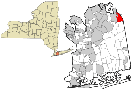 Location in Nassau County and the state of New York. | |
 Location within the state of New York | |
| Coordinates: 40°51′25″N 73°28′37″W / 40.85694°N 73.47694°WCoordinates: 40°51′25″N 73°28′37″W / 40.85694°N 73.47694°W | |
| Country |
|
| State |
|
| County | Nassau |
| Government | |
| • Mayor | Harvinder "Harry" Anand[1] |
| Area | |
| • Total | 3.1 sq mi (8.0 km2) |
| • Land | 2.9 sq mi (7.6 km2) |
| • Water | 0.2 sq mi (0.4 km2) |
| Elevation | 92 ft (28 m) |
| Population (2010) | |
| • Total | 1,952 |
| Time zone | Eastern (EST) (UTC-5) |
| • Summer (DST) | EDT (UTC-4) |
| ZIP codes | 11771, 11791 |
| Area code(s) | 516 |
| FIPS code | 36-41487 |
| GNIS feature ID | 0955090 |
| Website |
www |
Laurel Hollow is a village in the Town of Oyster Bay in Nassau County, New York in the United States. The population was 1,952 at the 2010 census.[2] According to Bloomberg BusinessWeek, Laurel Hollow is the 8th wealthiest town in America. [3]
Laurel Hollow is served by the Cold Spring Harbor Central School District in Cold Spring Harbor, with a small portion in Oyster Bay-East Norwich School District.
History
The settlement began around 1653 with purchase of land from the local natives. The village was incorporated in 1926 as "Lauralton," but the name was changed to "Laurel Hollow" in 1935 to avoid confusion with a location in Queens County, New York.
The famous Cold Spring Harbor Laboratory, is located in the village.
Points of interest
- Cold Spring Harbor Laboratory, which specializes in genetics research.
- Fish Hatchery and Learning Center.
- Laurel Hollow Beach, on the west coast of Cold Spring Harbor's inner harbor.
Geography
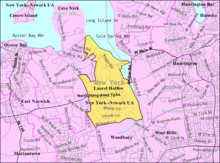
Laurel Hollow is located at 40°51′25″N 73°28′37″W / 40.85694°N 73.47694°W (40.856991, -73.477008).[4] The village is situated in Nassau County and creates a portion of Nassau's eastern border with Suffolk County. Hilly terrain predominates in the area, and the forests are mostly deciduous trees with a low canopy of laurel bushes that provide a low evergreen canopy. Route 25A passes through Laurel Hollow east-west.
According to the United States Census Bureau, the village has a total area of 3.1 square miles (8.0 km2), of which 2.9 square miles (7.5 km2) is land and 0.2 square miles (0.52 km2), or 5.18%, is water.
Demographics
| Historical population | |||
|---|---|---|---|
| Census | Pop. | %± | |
| 1930 | 161 | — | |
| 1940 | 110 | −31.7% | |
| 1950 | 169 | 53.6% | |
| 1960 | 834 | 393.5% | |
| 1970 | 1,401 | 68.0% | |
| 1980 | 1,527 | 9.0% | |
| 1990 | 1,748 | 14.5% | |
| 2000 | 1,930 | 10.4% | |
| 2010 | 1,952 | 1.1% | |
| Est. 2015 | 2,036 | [5] | 4.3% |
As of the census[7] of 2000, there were 1,930 people, 598 households, and 528 families residing in the village. The population density was 660.0 people per square mile (255.2/km²). There were 621 housing units at an average density of 212.4 per square mile (82.1/km²). The racial makeup of the village was 91.30% White, 0.88% African American, 6.84% Asian, 0.21% from other races, and 0.78% from two or more races. Hispanic or Latino of any race were 1.97% of the population.
There were 598 households out of which 44.8% had children under the age of 18 living with them, 81.8% were married couples living together, 5.4% had a female householder with no husband present, and 11.7% were non-families. 10.4% of all households were made up of individuals and 4.5% had someone living alone who was 65 years of age or older. The average household size was 3.20 and the average family size was 3.37.
In the village the population was spread out with 30.4% under the age of 18, 4.4% from 18 to 24, 21.7% from 25 to 44, 30.0% from 45 to 64, and 13.5% who were 65 years of age or older. The median age was 41 years. For every 100 females there were 88.8 males. For every 100 females age 18 and over, there were 87.0 males.
The median income for a household in the village was in excess of $200,000, as is the median income for a family. Males had a median income of over $100,000 versus $60,000 for females. The per capita income for the village was $83,366. About 0.7% of families and 1.9% of the population were below the poverty line, including 1.0% of those under age 18 and 7.3% of those age 65 or over.
Notable people
- John Lennon, member of The Beatles, owned a home with wife Yoko Ono in Laurel Hollow at the time of his death.[8]
- Louis Comfort Tiffany, the artist and decorative designer whose glass vases, lamps and windows depict scenes inspired by the view from Laurelton Hall, his estate in Laurel Hollow, and three of whose stained glass windows are housed in St. John's Episcopal Church in Cold Spring Harbor
- James D. Watson, co-discoverer of the double-helix structure of DNA and former chancellor of Cold Spring Harbor Laboratory
- Doug Morris, Chairman and CEO of Sony Music Entertainment. He previously served as Chairman and CEO of the Universal Music Group from 1995 to 2011. Founder (and former Chairman) of VEVO.[9]
- Jay Gould, leading American railroad developer and speculator. His success at business made him the ninth richest U.S. citizen in history. Built Cedar Knolls for his grandson Frank Gould. [10]
References
- ↑ Incorporated Village of Laurel Hollow, The Incorporated Village of Laurel Hollow. Accessed March 11, 2008.
- ↑ "Race, Hispanic or Latino, Age, and Housing Occupancy: 2010 Census Redistricting Data (Public Law 94-171) Summary File (QT-PL), Laurel Hollow village, New York". U.S. Census Bureau, American FactFinder 2. Retrieved October 4, 2011.
- ↑ http://images.businessweek.com/ss/09/03/0317_richest_zips/9.htm
- ↑ "US Gazetteer files: 2010, 2000, and 1990". United States Census Bureau. 2011-02-12. Retrieved 2011-04-23.
- ↑ "Annual Estimates of the Resident Population for Incorporated Places: April 1, 2010 to July 1, 2015". Retrieved July 2, 2016.
- ↑ "Census of Population and Housing". Census.gov. Retrieved June 4, 2015.
- ↑ "American FactFinder". United States Census Bureau. Retrieved 2008-01-31.
- ↑ http://coldspringharbor.com/notable-people/
- ↑ http://www.whitepages.com/name/Douglas-P-Morris/Syosset-NY/26knpks
- ↑ http://www.oldlongisland.com/2010/07/cedar-knolls.html