Lavedan
| Lavedan | |
|---|---|
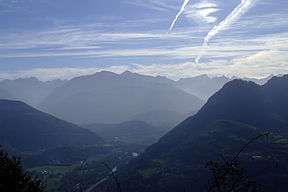 |
The Lavedan (in gascon eth/lo Lavedan, /et/lu laβedã/), or occasionally vallées des Gaves, denotes a mountainous natural region of France, located at the heart of the Pyrénées, and forms a group of valleys upstream of Lourdes.
The Lavedan is historically part of the Gascony province and of the county of Bigorre. Today, it is situated in the Hautes-Pyrénées department in the Midi-Pyrénées region.
Etymology
The name "Lavedan" is documented under ancient forms:[1] in pago Lavetanense (v. 860),[2] Levitanensis vicecomes (v. 980),[2] vicecomites Levitanicæ vallis (v. 1060),[3] Ramundus de Levitania (1095),[4] homines Baredgie et Levitani (v. 1110),[5] A. de Laueda (1114),[6] Aramon Garsie de Lavedan (1283),[7] terram de Lavedaa (1285).[8]
Il is made up of the Latin -etan, -itan suffix, typically present in names of iberian peoples. Le radical est Lau- / Leu-.
Geography
Topography
The Lavedan is made up of 7 valleys, which in the past formed relatively self-sufficient and autonomous entities (they were named under vath, arribèra « valley » ou d'estrem « excentred valley ») :
- La Vath Surguèra (prononcé 'Bat surguère')
- A small valley on the left bank at the entrance of the Lavedan which groups the towns of Ségus, Aspin-en-Lavedan, Ossen, Omex, Viger.
- L'estrem de Castèth-lobon (pronounced 'Casteth Loubou') or Castelloubon
- which corresponds to the Néez basin, located on Cheust and Ourdis-Cotdoussan (the name comes from Castellum Lupi "Wolf castle", founded by the first count of the Lavedan, Mansion Loup of the Loup dynasty[9] from which dukes of Gascony and counts of Bigorre were born, at the beginning of the 10th century, the viscounts' residence until the beginning of the 11th century, it comprises the towns of Juncalas, Geu, Ger, Lugagnan, Saint-Créac (which today includes Antalos and Justous), Ousté, Berbérust-Lias, Ourdis-Cotdoussan, Germs-sur-l'Oussouet, Cheust, Gazost, Ourdon.
- L'estrem de Sala ou Estrèm de Salles
- Argelès (formerly Ourout and Vieuzac, which became Argelès-Gazost in 1897), Ayzac-Ost, Agos-Vidalos, Ouzous, Salles, Sère-en-Lavedan, Gez.
- The val d'Azun
- constituted of the Arren and Estaing valleys as well as the Bergons and the right bank of the high valley of l'Ouzoum, comprises the villages of Arrens, Marsous, Aucun, Gaillagos, Arcizans-Dessus, Arras-en-Lavedan, Sireix, Bun, Estaing, Arbéost, Ferrières (including Hougarou).
- Le Davant-Aiga (pronounces Dabant-Aygues = East of the waters)
- It correspond to the eastern bank of the gave du Lavedan and includes the towns of Préchac, Boô-Silhen (including Asmets), Saint-Pastous (including Senta-Maria), Ayros-Arbouix, Vier-Bordes, Artalens-Souin, Beaucens, Villelongue (including Ortiac).
- L'arribèra de Sent Savin ou Rivière de Saint-Savin
- Saint-Savin, Lau-Balagnas, Adast, Pierrefitte-Nestalas, Soulom, Uz, Cauterets, Arcizans-Avant.
- The Barèja valley (French 'Barège') named « Pays Toy »
- Luz-Saint-Sauveur, Sassis, Sazos, Grust, Saligos, Chèze, Viscos, Vizos, Esquièze-Sère, Esterre, Viella, Betpouey, Barèges, Sers, Viey, Gèdre, Gavarnie.
Hydrography
The Lavedan corresponds to the Gave de Pau bassin, upstream from Lourdes namely with the valleys of the Gave de Gavarnie, the Gave de Cauterets and the Gave d'Azun.
Delimitation
The Lavedan communicates with the vallée de Campan (vallée de l'Adour) by the col du Tourmalet and with the vallée d'Ossau by the cirque du Litor (east of col d'Aubisque ; the left bank of the vallée de l'Ouzom is part of Ossau while the right bank is part of the val d'Azun). It is separated from the Aragon by the franco-spanish border, traversable by numerous ports.
Main sites
The main towns are Argelès-Gazost, Pierrefitte-Nestalas, Cauterets, Luz-Saint-Sauveur, Gèdre and Gavarnie.
The major mountain sites are :
Notes and references
- ↑ Michel Grosclaude, Jean-François Le Nail, Dictionnaire toponymique des communes des Hautes-Pyrénées
- 1 2 Livre vert de Bénac.
- ↑ Cartulaire de Saint-Savin.
- ↑ Cartulaire de Saint-Pé.
- ↑ Fors de Bigorre.
- ↑ Cartulaire de Bigorre ; pour Arnaldo de Laueda (n. de p.).
- ↑ Procès Bigorre ; Raymond Garcie de Lavedan (n. de p.).
- ↑ Montre Bigorre.
- ↑ Dukes of Gascony
Coordinates: 43°00′00″N 0°06′00″W / 43.0000°N 0.1000°W